| BKP Bingham’s Kennebec Purchase |
| BPP Bingham’s Penobscot Purchase |
| ED Eastern Division |
| EKR East of the Kennebec River |
| EPR East of the Penobscot River |
| EUR East of the Union River |
| IP Indian Purchase |
| LS Livermore Survey |
| MD Middle Division |
| NBKP North of Bingham’s Kennebec Purchase |
| NBPP North of Bingham’s Penobscot Purchase |
| ND Northern Division |
| NWP North of Waldo Patent |
| OIP Old Indian Purchase |
| SD Southern Division |
| TS Titcomb Survey |
| WELS West of the Easterly Line of the State |
| WBKP West of Bingham’s Kennebec Purchase |
| WKR West of the Kennebec River |
is the designation of minor civil divisions that have no organized local government, such as a plantation, town or city.
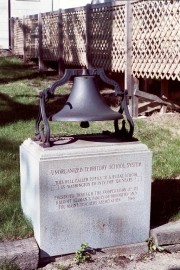
Townships are administered directly by the State government. Taxes are due directly to the State Bureau of Taxation, with funds disbursed to support township services such as schools. The bell at right, on the grounds of the State House in Augusta, commemorates the State’s education efforts in the unorganized townships: “This bell called pupils to a rural school in Washington County for 124 years.”
Townships may have names or may simply be designated by a township and range identification, such as T3 R4 WELS or T5 ND BPP. T stands for township, and R indicates a range.
WELS is an abbreviation for “West of the Easterly Line of the State,” referring to the north-south line extending from Hamlin in the north to Amity in the south in Aroostook County. It provides a reference for the townships west of this line.
Townships are designated occasionally by letters, but primarily by the numbers 1 through 19 from south to north, the southernmost being TB R11 WELS just north of Katahdin Iron Works Township in Piscataquis County. Ranges are counted from the easterly line toward the west, although no townships exist in the first range. Three unnamed townships in the second range are designated TA R2 WELS, TC R2 WELS and TD R2 WELS. The western most township is designated T5 R20 WELS on the Quebec border in Somerset County.
A town that has become a township is said to have “deorganized” to become an unorganized township.
The Unorganized Territory includes 9,284,166 acres of land, of which:
7,550,783 acres are in the Tree Growth current use program and, therefore, have reduced
valuation for tax purposes. 1,167,795 acres are exempt from property tax, such as State and Federal land. Cost of these services was about $30 million in 2013.
The 421 townships have a full-time resident population of 7,900 people. The 2010 census estimated there are 11,068 seasonal structures that house approximately 26,895 non-residents. Among 101 offshore islands, only one has a full-time resident population, consisting of four people.
The Unorganized Territory has approximately 379 miles of summer roads and 570 miles of winter roads. The territory is located within thirteen of the sixteen counties. Municipal type services are required in only nine of these counties. Maine law provides for a tax to be levied in the territory for educational and other municipal-like services for residents. Various State departments provide for timber management, forest fire prevention and suppression, conservation and land management, land use planning, emergency assistance, roads and bridges, and related services.
Additional resources
“Unorganized Territory, Fiscal Year 2013 Annual Report.” Office of the State Auditor. January 26, 3015. https://www.maine.gov/audit/documents/2013utreport.pdf (accessed December 25, 2019)


