
Location Map for Topsham
| Year | Population |
|---|---|
| 1970 | 5,022 |
| 1980 | 6,431 |
| 1990 | 8,746 |
| 2000 | 9,100 |
| 2010 | 8,784 |
| Geographic Data | |
|---|---|
| N. Latitude | 43:57:48 |
| W. Longitude | 69:57:34 |
| Maine House | District 54 |
| Maine Senate | District 23 |
| Congress | District 1 |
| Area sq. mi. | (total) 35.4 |
| Area sq. mi. | (land) 32.0 |
| Population/s.mi | (land) 275.0 |
County: Sagadahoc
Total=land+water; Land=land only |
|

Population Trend 1800-2010
")
Topsham Mill (2001)
Head of Tide Park on Cathance River (2009)
[TOPS-suhm] in Sagadahoc County, was incorporated on January 31, 1764 as the nineteenth town in Maine. In 1788 it annexed Patten’s Point from Bowdoinham, but ceded other land to that town in 1830. A twenty-foot waterfall from the Cathance River flows into a tidal offshoot of Merrymeeting Bay. Bald eagles, heron, and osprey can frequently be seen in the area hunting for the numerous fish that patrol the tidal zone. The site was an important for the Native Americans that once lived in the region. It was also the site of the town’s first sawmill.
Settling the Topsham-Brunswick area was dangerous business in the 17th century. After repeated defeats at the hands of the Indians, the Pejepscot Proprietors bought the region in 1699 and in 1714-1715 developed the two towns along the lower Androscoggin River. Yet again the towns were destroyed in 1722 – for the last time. After Brunswick regained its composure and incorporated in 1739, Topsham was on the path to its own separate existence in 1764.
")
Mill at Pejepscot Village (2002)
")
Pejepscot Schoolhouse (2002)
Falls in the Androscoggin River between the two towns encouraged the development of power sources for paper and textile mills which dominated the local economy into the 20th century. The Topsham Mill, in the photo above, was built in 1868 and was one of the first two wood pulp mills in the United States and the first in Maine. The building is now adapted to commercial and professional uses.
Topsham has been a very rapidly growing community both in population (up 41% in the 20 years before the close of Brunswick Naval Air Station) and in commercial development in the area of the Topsham Fair Mall, strategically located adjacent to Interstate 95.
")
Town of Topsham Municipal Offices (2010)
")
Municipal Complex Sign with Public Safety Building (2010)
In 1893, F. C. Whitehouse of Topsham, who owned paper mills in Lisbon Falls and Topsham, began construction of a third mill, the Pejepscot, and a dam on the eastern banks of the Androscoggin River several miles north of the main village.
")
Former Store and Post Office in Pejepscot Village (2002)
Pejepscot Village, near the mill site, was once an active community when the Pejepscot Paper Mill was in full production. Now the 1899 Pejepscot School has been restored and is used for community purposes, but activity at the mill site no longer requires the workers it once did. See the 1929 School Report from Topsham Annual Town Report for references to the Pejepscot Company and the school.
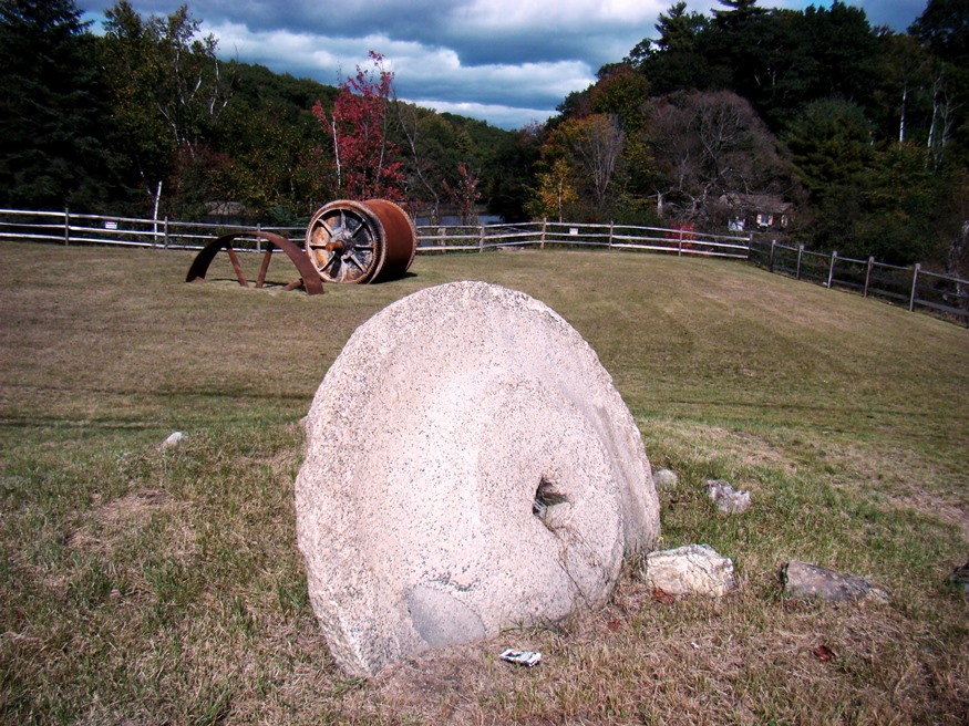
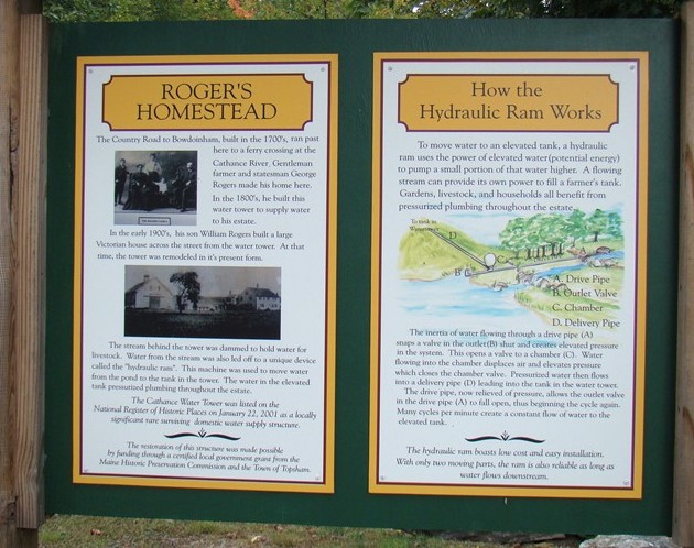
Remains of earlier structures hint at the town’s history. The water tower (restored) below was part of a “hydraulic ram system” documented at the site. It was built in the 19th century to serve a nearby farm. A small park accompanies the remnants of the mill dam below. It includes mill machinery and a grinding stone. The windmill sits in a pasture near farm buildings, probably to pump water for the stock.
")
Water Tower (2009)
")
Remains of a Mill Dam (2009)
")
Windmill, Foreside Rd. (2010)
During much of the 20th century, paper mills and other industries used Maine rivers as virtual sewers for their waste material. In the 1960’s and 1970’s strong efforts to reduce water pollution, led by Maine’s U.S. Senator Edmund Muskie, began to have an effect. The Androscoggin River, which flows between Topsham and Brunswick and empties into Merrymeeting Bay, was the most polluted river in the state. Thanks to documentation of the problem by the U.S. Environmental Protection Agency (EPA), and federal laws, the river and the bay have both recovered substantially.
")
")
")
")
")
")
Recently the downtown (pictured above at N43° 55′ 24.6″ W69° 57′ 51.4″) has witnessed a renewal with modern buildings. Topsham has been a very rapidly growing community both in population (up 41% in the 20 years before the close of Brunswick Naval Air Station) and in commercial development in the area of the Topsham Fair Mall, strategically located adjacent to Interstate 95.
Several bridges span the Androscoggin River between Topsham and Brunswick, including a historic pedestrian suspension bridge and the double-decker Black Bridge.
Benjamin Randall, a 19th century State Senator and later U.S. Representative, was born here. Rev. Frank Sanford gave up his position as Baptist minister here to found his religious movement and building Shiloh Temple in Durham.
The Cathance River flows through the town and into Merrymeeting Bay via Bowdoinham, with the 230-acre Cathance River Preserve and Watershed along the river in Topsham.
The Bradley Pond Farm Preserve features 2½ miles of trails for hiking and cross-country skiing on a private working farm are maintained by the Brunswick-Topsham Land Trust. It is located at the end of the Bradley Pond Road, which intersects Route 201 less than four miles north of the intersection of Routes 201 and 196.
Form of Government: Town Meeting-Select Board-Manager.
Additional resources
Brunswick and Topsham. Compiled by Joyce K. Bibber. Dover, N.H. Distributed by Berwick Pub., c1994.
“Head of Tide Park.” Town of Topsham. https://www.topshammaine.com/?SEC=EED27DC1-13EF-47BB-ABDF-C3D9F5142E53
Souvenir of Topsham, Me., 1911. Brunswick, Me. Maine Map & Register. 1911. [Maine State Library]
*Maine. Historic Preservation Commission. Augusta, Me. Text from National Register of Historic Places: http://pdfhost.focus.nps.gov/docs/nrhp/text/xxxxxxxx.PDF
Cathance Water Tower: 00001637.PDF
Pejepscot Paper Company: 74000192.PDF
Randall-Hildreth House: 04001048.PDF
Topsham Fairgrounds Grandstand: 92000277.PDF
Topsham Historic District: 78000198.PDF
Main Street Group. The Main Street Vision: a plan for reclaiming Topsham Village. Topsham, Me. The Group. [1996?] [Curtis Memorial Library]
Topsham Academy (Topsham, Me.) Catalogue of the officers and students of Topsham Academy: spring term, 1853. Brunswick, Maine. From J. Griffin’s Press. 1853? [University of Maine, Raymond H. Fogler Library, Special Collections]
Town of Topsham. Topsham Comprehensive Plan Update Committee. Topsham Comprehensive Plan 2005: Adopted May 19, 2005: Proposed 2006 Revisions. Town of Topsham, Me. 2006. [Maine State Library]
Wheeler, George A. and Henry W. Wheeler. History of Brunswick, Topsham and Harpswell, Maine.
National Register of Historic Places – Listings
Cathance Water Tower
[Cathance Road junction with Beechwood Drive; N43° 57′ 5.64″ W69° 55′ 49.20″] The Cathance Water Tower (photo above) is a two-stage wooden frame structure built by the Rogers family to supply the domestic water needs of their nearby residence. It was probably built in the last quarter of the 19th century. The water tower was part of a complex of buildings that formed the Rogers Homestead. The water tower stands to the northeast of this site and on the opposite side of the road. Little verifiable information exists pertaining to the history of the Water Tower. At one time it was on the Topsham Fairgrounds, but later returned to its present site. The implication is that the tower was originally built on or near the existing site, but it has not been determined when it was built or relocated. However, circumstantial evidence suggests that it has been located here for at least sixty years. The tower and its immediate site are owned by the Town of Topsham.
Information at the Water Tower (2009)
Water towers that served domestic needs may have been common in Maine historically, but they are very rare today. The only other comparable structure in Maine is the Bailey Farm Windmill, an octagonal wood shingled frame tower which was built to pump, but not store, water for the farm on which it stands. The construction of structures like the Cathance Water Tower made it possible to benefit from the availability of fresh water by way of a pressurized delivery system, and to create protected storage for a large volume of water.*
Hunter Site, Address Restricted
Pejepscot Paper Company
") [off U.S. 201 at the Androscoggin River; N43° 55′ 17.64″ W69° 57′ 54.24″] The first wood pulp mills operated in Maine were in Norway and Topsham. The Topsham Mill was built in the latter part of 1868. The Topsham Paper Company used grinders from the machine shop of the Bath Iron Works and grew rapidly from its humble beginnings in the basement of a sawmill run by Charles D. Brown and E. B. Denison. The success of this early venture caused Brown and Denison to branch out with other mills. Over expansion, trouble with the other patent holders and a relatively poor location caused the firm to go out of business in the mid 70’s.
[off U.S. 201 at the Androscoggin River; N43° 55′ 17.64″ W69° 57′ 54.24″] The first wood pulp mills operated in Maine were in Norway and Topsham. The Topsham Mill was built in the latter part of 1868. The Topsham Paper Company used grinders from the machine shop of the Bath Iron Works and grew rapidly from its humble beginnings in the basement of a sawmill run by Charles D. Brown and E. B. Denison. The success of this early venture caused Brown and Denison to branch out with other mills. Over expansion, trouble with the other patent holders and a relatively poor location caused the firm to go out of business in the mid 70’s.
") The Company failed in 1874. Four months later the Bowdoin Paper Manufacturing Company was organized with Adna T. Denison as its treasurer. Denison saw the future in wood pulp paper and was one of the pioneers of that industry. The complex of Maine Mills under Denison’s control were the first companies in Maine to grow beyond humble beginnings. Before his empire collapsed under the auctioneer’s hammer in 1887, he owned and opened mills in Portland, Mechanic Falls, Canton, Norway, and the mill at Topsham.
The Company failed in 1874. Four months later the Bowdoin Paper Manufacturing Company was organized with Adna T. Denison as its treasurer. Denison saw the future in wood pulp paper and was one of the pioneers of that industry. The complex of Maine Mills under Denison’s control were the first companies in Maine to grow beyond humble beginnings. Before his empire collapsed under the auctioneer’s hammer in 1887, he owned and opened mills in Portland, Mechanic Falls, Canton, Norway, and the mill at Topsham.
") The paper industry at Topsham did survive, The mill continued to produce paper into the late 20th century under the name of the Pejepscot Paper Company. It used the ground wood process beginning the real birth of an industry which in the 20th century would become “King” in Maine. Unlike most other paper mills of its period, the Pejepscot Company was an outstanding example of mid-19th century industrial architecture and site location. Built at Brunswick Falls on a site used as a water power source since the 18th century, the main mill building and its surroundings present a classic picture of 19th century industrial New England.*
The paper industry at Topsham did survive, The mill continued to produce paper into the late 20th century under the name of the Pejepscot Paper Company. It used the ground wood process beginning the real birth of an industry which in the 20th century would become “King” in Maine. Unlike most other paper mills of its period, the Pejepscot Company was an outstanding example of mid-19th century industrial architecture and site location. Built at Brunswick Falls on a site used as a water power source since the 18th century, the main mill building and its surroundings present a classic picture of 19th century industrial New England.*
The mill building, in 2016, housed a restaurant and several professional offices.
Pejepscot Site, Address Restricted Pejepscot
Purinton Family Farm, 65 Elm Street [apparently demolished]
Randall-Hildreth House
") [806 Foreside Road; N43° 57′ 0.00″ W69° 53′ 42.00″] The 1800 Randall-Hildreth house is a notable example of an early 19th century rural mansion house with elements of Georgian and Federal architecture built for local gentry and occupied by William Randall’s family for the next 196 years. The twin-chimney, center hall house contains good examples of Federal woodworking on the interior and features an extremely rare cellar kitchen. The house was stylistically updated slightly over the next five generations as new architectural styles were adopted on the best houses in the region. Thus it also reflects some of the most prevalent 19th century stylistic trends including the Greek Revival and Queen Anne.
[806 Foreside Road; N43° 57′ 0.00″ W69° 53′ 42.00″] The 1800 Randall-Hildreth house is a notable example of an early 19th century rural mansion house with elements of Georgian and Federal architecture built for local gentry and occupied by William Randall’s family for the next 196 years. The twin-chimney, center hall house contains good examples of Federal woodworking on the interior and features an extremely rare cellar kitchen. The house was stylistically updated slightly over the next five generations as new architectural styles were adopted on the best houses in the region. Thus it also reflects some of the most prevalent 19th century stylistic trends including the Greek Revival and Queen Anne.
")
")
Functionally, the House is an example of a floor plan that was easily and practically divided into two distinct sets of living quarters with separate entrances and mirror interior layouts. Although the configuration changed periodically, the structure housed more than one family group in separate apartments for at least half of the 19th century and several decades into the next, eventually adding two ells to further accommodate the occupants.
Between 1800, when Randall built the house, and 1933 when his great-great grandson Alvah H. [Harold] Hildreth inherited it, the structure was apparently shared by more than one family in seven out of 13 census counts. In general this occurred when offspring matured and married.*
Topsham Fairgrounds Grandstand
") [off North side of Elm Street, East of junction with Fair Circle; N43° 55′ 39.00″ W69° 57′ 12.36″] Built between 1863 and 1877 and apparently enlarged twice thereafter, the Topsham Fairgrounds Grandstand is a distinctive structure represented by few examples in the State. It is one of only three known existing grandstands built by a 19th century county agricultural society.
[off North side of Elm Street, East of junction with Fair Circle; N43° 55′ 39.00″ W69° 57′ 12.36″] Built between 1863 and 1877 and apparently enlarged twice thereafter, the Topsham Fairgrounds Grandstand is a distinctive structure represented by few examples in the State. It is one of only three known existing grandstands built by a 19th century county agricultural society.
Two other similar structures are in Fryeburg and in Farmington. Both share similar characteristics to the one in Topsham including their great length, narrow width, and the sheltering gable roofs with semi-exposed gable ends. They date, respectively, to about 1885 and 1887, making the structure in Topsham perhaps the oldest of the three.
The Sagadahoc Agricultural and Horticultural Society held its first meeting at Bath in July 1854. The Society’s first fair was held in October 1855 near the current fairgrounds. Like similar fairs held throughout Maine, a wide range of exhibits and livestock were on display with premiums awarded to the best. These events were designed to promote the use of improved methods of agriculture.*
Topsham Historic District
 N43° 55' 35.94\" W69° 57' 44.46\"")
District Street Signs (2016)
[Elm, Main, and Green Streets; N43° 55′ 35.94″ W69° 57′ 44.46″ (Elm and Pleasant Street)] The first saw mills in Topsham on the Androscoggin were built prior to 1772. Soon at least five more mills were built. Manufacturing lumber during the first part of the 19th century made Topsham the most active commercial center for the area west of Bath. Other industries such as paper and box manufacturing and feldspar mining were established and a whole range of professions emerged.
 N43° 55' 37.34\" W69° 57' 44.40\"")
Historic District (2016) @
With subsistence farming no longer the dominant occupation, residential communities emerged where men could be close to their work in the village. Such was the beginning of the Topsham Historic District near the town center. The elegant Federal style home of a wealthy village merchant could be found beside the modest Capestylehouse of a village laborer because both owners and their families wanted close proximity to the village.
 N43° 55' 35.46\" W69° 57' 44.48\"")
Historic District (2016) @
 N43° 55' 39.94\" W69° 57' 48.30\"")
Historic District (2016) @
The slope of the land afforded a magnificent river view, adding to the area’s attraction. The nearby village provided access to Brunswick across the river, first by boat, and in 1796, by toll bridge. The Topsham Historic District preserves an area of development that emerged from two American lifestyles: the pioneer settler and the working class land owner. It appears today much as it was during its heyday in the 19th century. That is largely due to local builders, such as the prominent Samuel Melcher, who were able to develop architectural styles with a consistent manner of construction and appearance.
")
")