| Year | Population |
|---|---|
| 1970 | 377 |
| 1980 | 322 |
| 1990 | 272 |
| 2000 | 282 |
| 2010 | 267 |
| Geographic Data | |
|---|---|
| N. Latitude | 47:09:03 |
| W. Longitude | 68:45:59 |
| Maine House | District 151 |
| Maine Senate | District 1 |
| Congress | District 2 |
| Area sq. mi. | (total) 51.8 |
| Area sq. mi. | (land) 50.3 |
| Population/sq.mi. | (land) 5.3 |
County: Aroostook
Total=land+water; Land=land only |
|
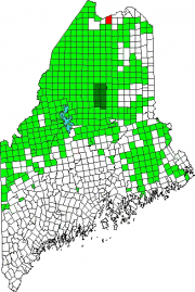
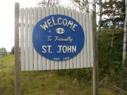
ST.JON] is a plantation in Aroostook County, organized for election purposes in 1859, 1860, and 1868, for assessment of taxes in 1871, and for general purposes on June 17, 1874, according to records at the State Archives. However, the Welcome sign at right says it was “Established” in 1870.
Prior to the 1859 “organization,” Hancock Plantation included the current areas of St. John and surrounding towns.
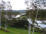
With the St. John River as its northern boundary, the town is located nearly at the end of Maine Route 161, a dead end road that travels west from Fort Kent to serve the small communities along the River. In the 19th century, a stage line traveled this route from Fort Kent to St. Francis, just west of St. John.
The Plantation has several modest sized lakes, including Wallagrass Lakes (Lakes 1 and 2) in the southeast, Wheelock Lake in the northeast, and Hunnewell Lake in the west.
St. John hosts two lots of Maine Public Reserved Lands totaling 1,167 acres.
According to the Maine Department of Conservation, Bureau of Parks and Lands Northern Aroostook Region Management Plan,
A deeded right-of-way leads to the North lot from the Franklin School Road. Access to the South lot is across private land. There are two cabins on the South lot leased for snowmobile club use. A spruce budworm salvage project took place on the North lot in 1982. The Bureau harvested 4,000 cords on the South lot from 1999-2000. The interior road system on the South lot was constructed for summer timber harvesting purposes.
Form of Government: Assessors-Annual Meeting.
Additional resources
Carlson, Shirlee Connors. Landings, Logging & Lumbermen: Part II, Logging on Maine Rivers. Fort Kent, Me. The Author. c2001.
Hafford, Faye O’Leary. Where the Heck is Wheelock, Maine?: Tales of St. John Plantation. F.O. Hafford?. 2002? [Maine State Library]
Maine. Department of Conservation. Bureau of Parks and Lands. Northern Aroostook Region Management Plan. Augusta, Me. June 2007. http://www.maine.gov/doc/parks/programs/planning/northern/plan.pdf (accessed April 2, 2012)
*Maine. Historic Preservation Commission. Augusta, Me. Text and photos from National Register of Historic Places: http://pdfhost.focus.nps.gov/docs/nrhp/text/xxxxxxxx.PDF and http://pdfhost.focus.nps.gov/docs/nrhp/photos/xxxxxxxx.PDF
Roosevelt School: 92001706.PDF
St. John Catholic Church: 03000017.PDF
National Register of Historic Places – Listings
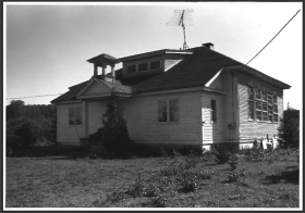
Roosevelt School
[Maine Route 161 south side, .1 mile east of private road 861] Probably built in the early 1920s and used until 1969, the Roosevelt School was designed for grades 1-5. It is the only historic school building in St. John Plantation and, although now used as a part-time summer residence, retains a high degree of architectural integrity.
Although little documentary evidence exists about the nature of the schools in this community, the 1913 edition of the Maine State School Report notes the existence of three school buildings at that time. It is likely that the present building was put up in the 1920s, a time when very similar schools were being built across the State. The Roosevelt School is significant from an architectural standpoint as a representation of a model school building for primary grades. The design probably came from the State since others of similar design were built in Aroostook County at the time. One such model was briefly described and illustrated in the 1920 School Report.* [Kirk Mohney photo]
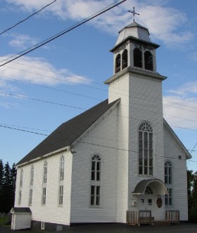
St. John Catholic Church
[St. John Road] The Saint John the Evangelist Catholic Church is a beautiful religious structure built between 1909 and 1911. Located on the north side of the only road in town, the church is sandwiched between the road and the St. John River. As a modern cathedral, this building combines a traditional floor plan with interior decorative elements that draw from Colonial Revival. It is a building that reflects both the ancestry of the French Canadian Catholics in St. John, the economic status of the residents, and a growing use of modern materials to mimic the more expensive hand-crafted decorative features of the past.
The religious architecture of the St. John Valley is prominent on the landscape. Since most settlements, villages and towns line the banks of the river, and the primary roads parallel the waterway, views through the valley continually include one or more large churches perched on a ridge, and usually facing the river. Tall belfries, and steeples either in pairs or alone are topped with statues or gold domes. Stained glass and large windows admit light into the interiors. Some of the buildings are moderate in size, while others are large, but without exception there is a grandeur and piousness built into each one.*


