

Location Map for Searsmont
| Year | Population |
|---|---|
| 1970 | 624 |
| 1980 | 782 |
| 1990 | 938 |
| 2000 | 1,174 |
| 2010 | 1,392 |
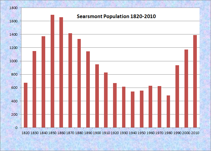
Population Trend 1820-2010
| Geographic Data | |
|---|---|
| N. Latitude | 44:21:39 |
| W. Longitude | 69:11:39 |
| Maine House | District 96 |
| Maine Senate | District 11 |
| Congress | District 2 |
| Area sq. mi. | (total) 39.2 |
| Area sq. mi. | (land) 37.8 |
| Population/sq.mi. | (land) 36.8 |
County: Waldo
Total=land+water; Land=land only |
|
")
[SEERZ-mont] is a town in Waldo County, settled in 1804 and incorporated on February 5, 1814 from Searsmont Plantation. David Sears of Boston, after whom the town is named, was one of ten who bought land in the area held by the heirs of General Samuel Waldo.
Located at the junction of several well-marked Indian trails, Native Americans called it Quantabacook. Author Ben Ames Williams called it Fraternity Village in his novel about the early white settlement of nearby Union.
Settled around 1780, Searsmont was named after David Sears of Boston, a proprietor of many lands in the area. Searsmont was known for its white pine timber and water resources. The first lumber mills were built before 1800 in North Searsmont.
")
Approaching Searsmont Village (2004)
The main village is located on the St. George River and is adjacent to Quantabacook Lake.
The lake’s name implies “abundant something lake or pond,” but that “something” is not clear to historians.
What is quite clear is that in 1764 some English hunters by the name of Richardson, apparently searching for that “something,” were trespassing on Indian hunting grounds in the area and were warned off by Captain Thomas Goldthwait, the commandant at Fort Point.
In the mid-19th century, Searsmont was briefly home to young Joseph B. Stearns, inventor of an improvement to telegraph technology that made him a wealthy man.
 N44° 21' 41.16\" W69° 11' 42.18\"")
Fire Department (2014) @
 N44° 21' 41.41\" W69° 11' 40.81\"")
Searsmont Village (’14) @
At about 8:15 AM on Sunday May 21, 1871 the third meteorite to land in Maine fell in the town.
 N44° 21' 41.52\" W69° 11' 39.72\"")
Fraternity Village General Store (2004) @
 N44° 21' 40.38\" W69° 11' 44.04\"")
St. George River in the Village (2014) @
Searsmont is served by Maine Routes 3, 131 and 173 and lies about ten miles southwest of Belfast.
On March 14, 1925 the first international radio broadcast was relayed from Belfast through Searsmont and on to New York City. That segment was called “the 10 mile long ‘Dog Island’ wave” which ended at Moody Mountain in south Searsport.
The Searsmont Community Building below houses the town office, the library, and the historical society’s museum.
 N44° 21' 39.90\" W69° 11' 25.56\"")
Post Office (2014) @
 N44° 21' 33.22\" W69° 11' 54.76\"")
Community Building (’14) @
 N44° 21' 33.52\" W69° 11' 55.25\"")
Historical Society (2014) @
The Georges River Land Trust has two nature preserves, Gibson and Porter, on the Woodmans Mills Road (Route 173) in the west of the township. James Dorso Ruffingham Meadow Wildlife Management Area is in its northwest corner, off Route 3 in North Searsmont. (two photos below)
 N44° 22' 11.69\" W69° 15' 35.51\"")
Sign at Porter Preserve, Georges River Land Trust @
 N44° 22' 11.94\" W69° 15' 35.46\"")
Osprey in Nest near Porter Preserve (2014) @
 N44° 21' 48.71\" W69° 15' 5.57\"")
Kiosk at Gibson Preserve (2014) @
 N44° 24' 22.37\" W69° 13' 17.30\"")
")
Form of Government: Town Meeting-Select Board-Administrative Assistant.
Additional resources
Albin, Dorothy. Searsmont: The Old Township of Quantabacook 1764-1976. Camden, Me. Camden Herald Publishing Co. Inc. 1977.
“America to Hear British Waves Relayed Nightly Next Winter.” New York Times. March 22, 1925. http://query.nytimes.com/mem/archive/pdf?res=F70711F838581A738DDDAB0A94DB405B858EF1D3 (accessed March 14, 2012)
Papers Relating to the Baptist Meeting House in Searsmont, Maine. 1845-1856. [Maine State Library]
Searsmont Historical Society. Historical Society News 2005. Vol. 3. Issue 1. 2005.
National Register of Historic Places – Listings
Georges River Canal
[Upper Falls, St. George River in Warren to Union town line, extending to Quantabacook Pond in Searsmont] Canals on Georges River, used for access to the forest in its watershed, were important for the development river valley. Mills were built at its lower falls. Charles Barrett of Hope secured a charter from the Massachusetts General Court in 1793 to build locks and bridges creating a canal. More information at Warren.
Hardscrabble Farm, east side Maine Route 131, 0.5 miles south of the junction with Maine Route 173
Moody Farm, junction of Lawry Road and Maine Route 173
Archeological Site No. 39.1, Address Restricted
In reading, I saw a reference to Hazeltine and Lothrop’s Mill in Searsmont on the George’s River. This is of great interest to me since Ansel Lothrop was my great-great-grandfather.
Ansel was born in Massachusetts and came, as a young man to Belfast prior to 1805. He was a blacksmith and moved to Searsmont around 1808. He became an important person in the organization of that town in 1814 and, for many years. Ansel had a son: Sumner Pattee Lothrop, (my great grandfather) who became a U.S. Navy ship’s Captain and died from exposure during the Civil War while on blockade duty on the Chesapeake Bay.
This is the first I have heard of a Lothrop’s Mill in Searsmont. Can you tell me about it, where exactly it was on the George’s River? Much of my family is buried in Belfast.
Thank you for your attention to my request.
Phil