")
Jordan Bay across Wetlands in Raymond (2003)

Location Map for Raymond
| Year | Population |
|---|---|
| 1970 | 1,328 |
| 1980 | 2,251 |
| 1990 | 3,311 |
| 2000 | 4,299 |
| 2010 | 4,436 |
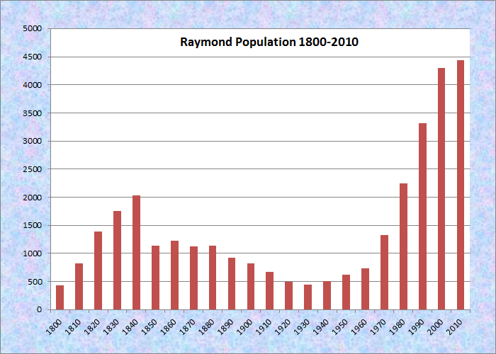
Population Trend 1800-2010
| Geographic Data | |
|---|---|
| N. Latitude | 43:55:10 |
| W. Longitude | 70:28:02 |
| Maine House | Dist 66,67 |
| Maine Senate | District 26 |
| Congress | District 1 |
| Area sq. mi. | (total) 46.2 |
| Area sq. mi. | (land) 33.3 |
| Population/sq.mi. | (land) 133.2 |
County: Cumberland
Total=land+water; Land=land only |
|
") [RAY-mund] is a town in Cumberland County, incorporated on June 21, 1803 from Raymond Plantation, once known as Raymondtown.
[RAY-mund] is a town in Cumberland County, incorporated on June 21, 1803 from Raymond Plantation, once known as Raymondtown.
In 1841 it gave up some land that formed the new town of Casco.
The main village is located at the head of the large, well protected, Jordan Bay on the shore of Sebago Lake.
Adjacent Raymond Neck extends over four miles into the Lake to form the Bay. Raymond’s “welcome” sign entices fishing enthusiasts to the “Home of the Landlocked Salmon,” which inhabit the lake.
Raymond is both a summer recreational community and a rapidly growing suburb of Portland.
Nathaniel Hawthorne spent summers at his mother’s home, built in 1812 by his uncle Richard Manning who lived in an equally impressive home nearby.
The home was in Raymond’s village of South Casco, but that village is now in the Town of Casco as a result of that town’s separation from Raymond.
Photos below note vacation properties on Raymond Neck on the shore of Sebago Lake and the Frye Island Ferry terminal at the end of Cape Road.
 N43° 50' 57.95\" W70° 30' 34.51\"")
Frye Island Ferry Dock (’13) @
 N43° 51' 1.60\" W70° 30' 36.11\"")
Ferry Terminal Ferry (2013) @
 N43° 50' 53.78\" W70° 30' 54.08\"")
House, Raymond Neck (’13)@
 N43° 51' 27.67\" W70° 31' 13.20\"")
House at Sebago Lake (’13) @
 N43° 51' 25.89\" W70° 31' 10.85\"")
Camp Wawenock (2013) @
 N43° 51' 39.42\" W70° 31' 16.33\"")
House off Cape Road (’13) @
East Raymond village, centered on Route 85, Webbs Mills Road, is the hub of most community buildings, as indicated below.
 N43° 56' 4.58\" W70° 26' 29.15\"")
Town Office (2013) @
 N43° 56' 5.28\" W70° 26' 29.20\"")
Clough General Store (2013) @
 N43° 54' 6.77\" W70° 28' 7.15\"")
Village Library (2013) @
 N43° 54' 9.15\" W70° 28' 39.16\"")
Bay View Farm (2013) @
 N43° 53' 53.71\" W70° 28' 1.48\"")
Community Church (2013) @
")
Community Church (c. 1914)
The Panther Pond outlet dam, on Mill Street, is owned and operated by the State of Maine’s Department of Inland Fisheries and Wildlife. Above the dam it appears that the ruins of an old mill dam jut into the stream.
 N43° 54' 7.28\" W70° 28' 7.03\"")
Community Garden (2013) @
 N43° 54' 4.39\" W70° 27' 54.50\"")
Panther Pond Dam (2013) @
 N43° 54' 4.59\" W70° 27' 55.56\"")
Upstream of the Dam (’13) @
Form of Government: Town Meeting-Select Board-Manager.
Additional resources Click on images to enlarge and clarify
Glassford, Martha Watkins. Raymond and Casco. Charleston, S.C. Arcadia Pub. c2011′
Knight, Ernest Harmon. Historical Gems of Raymond and Casco. Raymond, Me. Raymond – Casco Historical Society. 1996. [University of Maine, Raymond H. Fogler Library, Special Collections]
*Maine. Historic Preservation Commission. Augusta, Me. Text and photos from National Register of Historic Places: http://pdfhost.focus.nps.gov/docs/nrhp/text/xxxxxxxx.PDF and http://pdfhost.focus.nps.gov/docs/nrhp/photos/xxxxxxxx.PDF
East Raymond Union Chapel: 04000370.PDF
The Sebago Lake Area: Windham, Standish, Raymond, Casco, Sebago, and Naples. Dover, N.H. Arcadia Publishing. c1996.
National Register of Historic Places – Listings
East Raymond Union Chapel
")
[394 Webbs Mills Road, Maine Route 85] In 1884 at East Raymond, nine ladies and five gentlemen of the town met to form a Benevolent Society which was variously referred to as the ‘Ladies Benevolent Society’ or ‘Ladies Sewing Circle.'” So begins a history of the East Raymond Chapel that was prepared to celebrate the building’s 100th year in 1990.
 N43° 56' 3.06\" W70° 26' 27.18\"")
The Chapel is a relatively small building, proportionate to the scale of the village at whose center it resides. Its architectural form reflects both its community and religious significance. As a small building, it accommodates the size of the community. As a non-denominational Chapel it was open and inclusive. As a Queen Anne style building it nurtured individuals with a sense of warmth and the intimacy of home. Queen Anne and Gothic Revival style elements create a religious structure that reflected the values, mores and aesthetics of its community.*
Nathaniel Hawthorne House, See Casco.