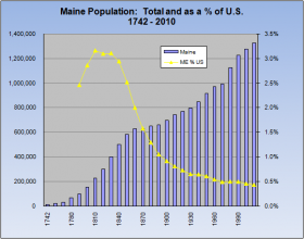
 The population of Maine is measured every ten years by the U.S. Census Bureau, and is estimated annually by the Department of Human Services. The graph at right illustrates the increases since 1742 and the declining portion of the U.S. population beginning early in the 19th century. (The U.S. Census began in 1790.)
The decline has had a political impact, reducing the size of Maine’s delegation in the U.S. House of Representatives from a high of eight down to two. The 1870 Census showed the first decline in the state’s population since records were kept. The westward migration after the Civil War contributed to what political leaders saw as a crisis. As a result special efforts were made to encourage immigration, best characterized by the Swedish Colony project.
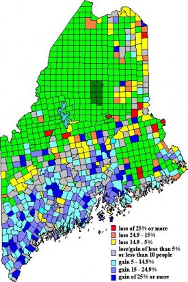
Gains and Losses – 1990-2000
Southern and western Maine cities, towns and plantations clearly identify the state’s growth area, with northern and eastern communities the frequent losers. Exceptions include the cities of Lewiston, Augusta, and Waterville, each of which lost more than 5% while most surrounding communities gained population. (The green areas on the map above represent unorganized townships.)
 Southern coastal counties, other than Washington, were consistent gainers. The largest communities, those over 15,000 in population, remain generally the same, but rank orders have changed somewhat from 1990.
Population Characteristics
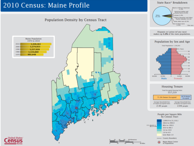
The population of Native American has centered primarily in those counties with reservations. African Americans have their greatest numbers in southern Maine. Veterans are relatively evenly dispersed, with a slightly higher proportion in the mid-coast counties of Lincoln and Sagadahoc.
Distribution by age indicate a greater portion of the under 18 population in western and southern counties. Older people (65 and over) are more frequently a larger share of county populations in the north and east of the state.
Maine Population 1742-2010
| Year | Maine | U.S. | ME % US |
| 1742 | 12,000 | ||
| 1760 | 20,000 | ||
| 1770 | 31,257 | ||
| 1780 | 65,000 | ||
| 1790 | 96,540 | 3,929,214 | 2.5% |
| 1800 | 151,719 | 5,308,483 | 2.9% |
| 1810 | 228,705 | 7,239,881 | 3.2% |
| 1820 | 298,335 | 9,638,453 | 3.1% |
| 1830 | 399,455 | 12,866,020 | 3.1% |
| 1840 | 501,793 | 17,069,453 | 2.9% |
| 1850 | 583,169 | 23,191,876 | 2.5% |
| 1860 | 628,279 | 31,443,321 | 2.0% |
| 1870 | 626,915 | 39,818,449 | 1.6% |
| 1880 | 648,936 | 50,155,783 | 1.3% |
| 1890 | 661,086 | 62,947,714 | 1.1% |
| 1900 | 694,466 | 75,994,575 | 0.9% |
| 1910 | 742,371 | 91,972,266 | 0.8% |
| 1920 | 768,014 | 105,710,620 | 0.7% |
| 1930 | 797,423 | 122,775,046 | 0.6% |
| 1940 | 847,226 | 131,669,275 | 0.6% |
| 1950 | 913,774 | 150,697,361 | 0.6% |
| 1960 | 969,000 | 179,323,175 | 0.5% |
| 1970 | 994,000 | 203,302,031 | 0.5% |
| 1980 | 1,124,660 | 226,545,805 | 0.5% |
| 1990 | 1,227,928 | 248,709,873 | 0.5% |
| 2000 | 1,274,923 | 281,421,906 | 0.5% |
| 2010 | 1,328,361 | 308,745,538 | 0.4% |
Maine and U.S. Population Trends
Maine’s population began to increase rapidly after the American Revolution, peaking at 3.2 percent of the national total, and accelerated up to the Civil War.
The post-war movement of Americans to explore the western reaches of the country had its effect. Worries about the loss of population between 1860 and 1870, provoked civic and political leaders to promote immigration. Governor Joshua Chamberlain was one who supported the recruitment of Swedes to northern Aroostook to what became known as the Swedish Colony.
During most of the twentieth century, population growth was moderate and lagged the general U.S. increase, reducing Maine’s portion of the country’s total from one percent to one-half percent. Substantial increases were recorded in 1970 and 1980, but again leveled off in 1990.
For more details on the composition of the current population see the Census Bureau’s Quick Facts summary.
Additional resources
Maine Department of Human Services. Population Estimates. Various years
U.S. Census Bureau, Census 2000 Redistricting Data (Public Law 94-171) Summary File, Matrices PL1, PL2, PL3, and PL4.
Decennial U.S. Census Reports.
Maine State Planning Office. Year 2000 Census Population Data. Spreadsheet. March 30, 2001.
U.S. Census. “2010 Census: Maine Profile.”
https://www2.census.gov/geo/maps/dc10_thematic/2010_Profile/2010_Profile_Map_Maine.pdf (accessed March 13, 2018)
U.S. Census Bureau. Annual Population Estimates. http://factfinder.census.gov/servlet/DatasetMainPageServlet?_program=PEP (accessed June 8, 2010)


