| Year | Population |
|---|---|
| 1970 | 887 |
| 1980 | 1,108 |
| 1990 | 1,166 |
| 2000 | 1,160 |
| 2010 | 1,119 |
| Geographic Data | |
|---|---|
| N. Latitude | 44:37:15 |
| W. Longitude | 67:23:05 |
| Maine House | District 139 |
| Maine Senate | District 6 |
| Congress | District 2 |
| Area sq. mi. | (total) 62.3 |
| Area sq. mi. | (land) 21.3 |
| Population/sq.mi. | (land) 52.5 |
County: Washington
Total=land+water; Land=land only |
|
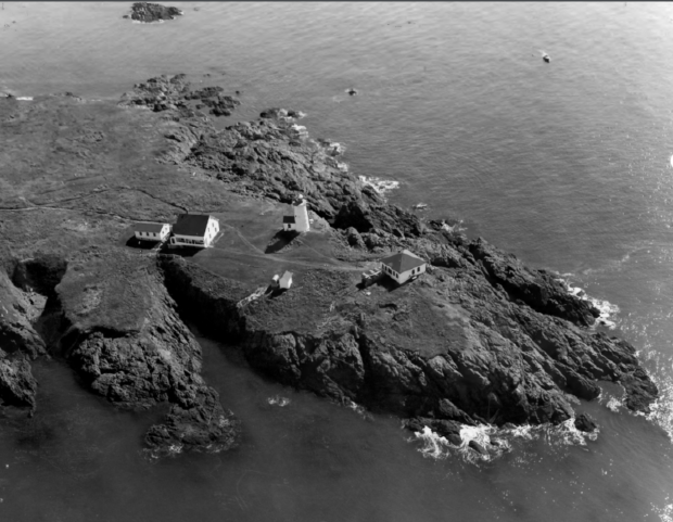
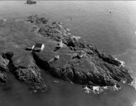
LIBBY ISLAND LIGHT STATION (1966)
CLICK TO ENLARGE
[mah-CHI-uhs-port]is a town in Washington County, incorporated on January 24, 1826 from part of old Machias.
Indian petroglyphs have been observed at Picture Rocks on Clark’s Point. Fort O’Brien guards the entrance to the Machias River at the south end of the main village.
The Larrabee Heath is a coastal raised peatland with appropriate plants such as black crowberry and baked-apple berry. There are a number of game trails which run through this sensitive habitat area managed by the Nature Conservancy.
The town lies primarily on the west side of Machias Bay as the Machias River enters the Bay. It offers many sheltered harbors including the well known Bucks Harbor. Machiasport was at the center of controversy in the late 1960’s when an oil terminal was proposed, unsuccessfully, for the quiet coastal community.
Machiasport is just east of Machias, and south of East Machias, on Maine Route 92.
Form of Government: Town Meeting-Select Board.
Additional resources
Frederic R. Harris, Inc. Engineering Feasibility of Marine Oil Terminal, Machiasport, Maine. New York. Frederick R. Harris, Inc. 1969.
Hammer, Armand. Let’s Keep the Record Straight on Machiasport: A Statement by Armand Hammer. New York. Occidental Petroleum Corporation. Supreme Printing Co. 1969.
*Maine. Historic Preservation Commission. Augusta, Me. Text and photos from National Register of Historic Places
New England Regional Commission. How the Atlantic World Port at Machiasport, Maine will Serve the National Interest. Boston, Mass. The Commission. Augusta, Me. Distributed by Maine Department of Economic Development. 1968.
State of Maine Bridge Division. Machiasport and East Machias Bridge Study; Machias River Bridge. Augusta, Me. 1967.
Tobey, Paul Layman. The Machiasport Tobeys Remembered. Rehoboth, Mass. P.L. Tobey. 1982.
National Register of Historic Places – Listings
Photos, and edited text are from nominations to the National Register of Historic Places researched by Maine. Historic Preservation Commission.
Full text and photos are at https://npgallery.nps.gov/nrhp
Fort O’Brien
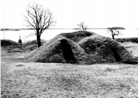
[South of Machiasport on a secondary road] Fort O’Brien’s history dates to the first naval battle of the Revolutionary War, which took place near the mouth of the Machias River on June 12, 1775. A few weeks after the Battle of Lexington and Concord a Machiasport shipowner, Ichabod Jones was escorted to Machiasport by the British ship Margaretta. The British captain was to make sure that Jones returned to Boston with lumber with which barracks were to be built. The Machiasport townspeople reacted to such an unsavory prospect and captured the Margaretta. The townspeople were led in these revolutionary activity by one Jeremiah O’Brien as well as by other members of the O’Brien family. The following month the Machias area men repulsed a retaliatory raid by a Nova Scotia based British schooner. The British then sent Sir George Collier with the Ranger and three other boats to punish the rebels.
The Colonists led by the O’Briens had erected a breastworks hoping to repulse the British. The fortifications did not prove strong enough however, and Collier routed the local force and burned several buildings before his fleet moved on. After the Collier raid, Washington ordered a regiment of militia recruited and sent to protect the settlement. In 1781 Fort O’Brien was made part of the National defense. The British, however, did not return until 1814 when they took the fort and burned the barracks. The fort was rebuilt again in 1863, during the Civil War in fear of Confederate privateer raids, but was not attacked.
Gates House
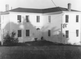
[Maine Route 92] Gates House is built into a slope close by the Machias River and commands a view of the site of the first naval engagement of the Revolution. Although rather plain in appearance, it is Federal style in character. It was the first such house in the area and, considering its construction date of 1807, is unique for the then remote site. The house was probably built by Nathaniel Phinney, Sr. on land originally owned by lsaac Larrabee, one of the area’s first settlers. It was purchased in 1813 by Nathan Gates, a trader, along with its adjoining wharves, barn and store. In the latter part of the 19th century, its wharves served as the terminus of the small Machiasport-Whitneyville Railroad, used to transport lumber to the piers for loading on coastal schooners. Lumbering was the principal industry of the area in the 19th century and was the reason for the existence of many Eastern Maine communities such as Machiasport. The house remained in the Gates Family until 1929.
Later its basement was used to house a clam business, and the its upper floor was partitioned. On June 12, 1775 the coastal sloop Unity engaged the British armed schooner Margaretta in what has been termed “The Lexington of the Seas.” This battle, which ended in a victory for the American side, was fought off Round Island in Machiasport Harbor close by the site of the Gates House. Since its purchase in 1966, the house has been used as headquarters and museum by the Machiasport Historical Society. Among its collections are numerous artifacts relating to the battle. [Pennel L. Worcester photo]
Libby Island Light Station
[south of Machiasport on Libby Island] Libby Island Light Station was ordered built by President James Monroe in 1822 and has never been rebuilt. According to old journals at the station there were thirty-five wrecks from 1856 to 1902, and out of this number only fifteen lives were lost owing to the efficient work and valor of the light keepers at the station. Among the ships lost to the sea near the Station were the Schooner Caledonia of Windsor, Nova Scotia. The captain and crew were swept overboard by the breakers but two passengers were rescued by the volunteer lifesaving crew from Starboard in 1878. The Bark Fame drifted shore on the point in a heavy gale; twelve of a crew of fifteen were rescued by the heroic keepers, who waded into the surf and threw a rope to the crew, then rigged a boatswain chair and got all but three ashore safely.
In 1892 the ship Princeport was wrecked on the bar between the two islands. After a perilous trip from the light, the keepers reached the small piece of the bow, all that remained of the ship, and rescued the crew. The Schooner F.C. Lockhart with all sails set, making a beautiful picture, struck the point where she lodged between a natural cradle of rocks. She had to be left there until the sea claimed her. The Barkentine John N. Myers met disaster on the southwest end of East Libby Island in 1925. The crew managed to make it to a small lonely island from which they were taken off by the Coast Guard the next morning. The last square rigger to go ashore at Libby Island was the Barkentine Africa in 1902. In a vain effort to save the ship, both anchors, weighing over 5000 pounds, were thrown overboard by the crew. They escaped to the Island by small boat. These anchors, the only remnants of a once proud ship exist today in an excellent state of preservation. [First Coast Guard District, Boston, Massachusetts photo]
(For the many shipwrecks along the coast enter shipwrecks in the search box above.
Liberty Hall
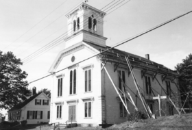 [Maine Route 92, Macomber Corner] During the latter half of the 19th century, the neighboring towns of Machias and East Machias had large public buildings that served as centers for governmental, educational and social functions. The town of Machiasport lacked such a building. At that time, it was a prosperous village and carried on an extensive trade in shipping lumber. It was the terminus for the Whitneyville and Machiasport Railroad and for the Portland, Bangor and Machias Steamboat Company. A large hotel had been built to cater to the steamer traffic. At the annual town meeting of March 3, 1873, the town voted to build a new town hall. By July, 1873, the contract had been awarded to Andrew R. Gilson of Machias. Liberty Hall was his most important project up to that time. He did contracting in Jonesport as well as around Machias. He is believed to have been the contractor in building the Porter Memorial Library in Machias.
Gilson was a selectman in Machias for many years and served several years in the Maine House of Representatives. Unlike the town halls at Machias and East Machias, the Machiasport Town Hall did not serve as a school. It was the primary social center for the town for concerts, public suppers, dances, plays, and performances by travelling lecturers and entertainers. It was the meeting place for the Grange, and for the Pocahontas and Redmen organizations. Older residents of Machiasport recall that almost every night there was some activity in the building. This important local landmark carried out in an impressive Italianate style has long been a source of pride to the community. [Earle G. Shettleworth, Jr. photo]
Marsh Stream Farm
Marsh Stream Farm is a particularly picturesque property located in in rural Washington County. Seven domestic and agricultural buildings are clustered at the junction of Marsh Stream and the East Branch of the Little Kennebec River. Over 200 acres of pasture, meadow and woodlot surround the buildings and create the country setting that has been the backdrop of this farm’s industry and agriculture since 1817. The farm consists of a house, English barn, woodshed, carriage shed, tool shed, chicken house and outhouse as well as the remains of a bridge/dam and the site of a wharf, mill and store. This small district exhibits the characteristics of a 19th century salt-water farm and contains a set of historic buildings dating between 1817 and the early 20th century. The farm is also agriculturally significant. The farm operated continuously for approximately 186 years, for much of this time concentrated on raising sheep. Although sheep farming was common in eastern Maine in the later 19th century the practice was widely abandoned in the 20th century and few sheep farms with historic buildings exist. Further illustrating the diversity of farm based economies, the property was also the site of a pre-Civil War lumber mill, store, dam, millpond and wharf.
Addresses restricted:
Birch Point, address restricted Native American Petroglyphs and Pictographs of Maine
Maine Archeological Survey site 62.46, address restricted
Hog Island, address restricted, Native American Petroglyphs and Pictographs of Maine
Holmes Point, address restricted, Native American Petroglyphs and Pictographs of Maine



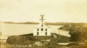
Does anyone have photos of the 1812 Baptist Meeting House on the East Side
of the Port? It was sold and razed 25 years ago, but perhaps photos retain
its history. If any pictures can be e-mailed, it would be greatly appreciated.