One observer, Richard Wood, has noted three phases in the organizational, development of the lumbering industry in Maine. Prior to statehood in 1820, it was characterized by the efforts of individuals, families, and partnerships. From then to 1880 an “era of cooperation,” led by lumbermen’s associations, reigned. After 1880, at a time when paper making was emerging, the industry came to be dominated by large organizations and corporations.

Logging Equipment at a Sawmill in Belgrade (2003)
From the earliest European presence, the woods of Maine have been a source of masts, boat building materials, and boards for housing and other structures. Later, the pulp and paper industry, and the recreational uses of hunting, hiking, and camping broadened its importance. Still later, people began to understand the role of forests in absorbing greenhouse gasses, providing habitat for wildlife, and protecting water resources.
As Governor Enoch Lincoln noted about the future of the “towering pines,”
Some of them will rise like spires amidst the naval armaments of his country & instead of the sighing of breezes in their tops, the flag of freedom shall gaily & proudly wave over them . . . Others will be compacted into magnificent palaces & be the instruments of comfort & the aide of health. (Wood, p. 20)
Initially the woods were seen to be an endless mass to clear, both for homes and farms, and for the value of its logs. The many indentations on the coast, and the major rivers plunging deep into the interior with its many lakes and ponds, offered cheap transportation to those who would exploit the resource.
Wesley McNair provides this brief review of the impact the British King’s thirst for masts had on Maine colonists:
Near the close of the 16th century, England had no trees suitable for masts in the largest warships. By this time, masts were brought to England from Denmark and Sweden. Even the smaller Baltic firs were being pieced together to make masts. When the Danes closed the mast trade in 1652, the Royal Navy turned to the rich forests of New England, even though the cost of transportation across the Atlantic was large.
Numerous trees were sometimes cut to get one good mast – on one occasion, in what is now the town of Durham, in 1762, there were cut 106 trees, of which 102 were found useless for masts. Other trees were damaged at falls or rapids as they were floated to a port. In the middle of the 18th century, a good Maine pine mast brought as much as $1,000 in 1976 purchasing power.
At first there was no royal claim on particular trees. The masts were supplied under a contract system, and their shipping points are preserved to this day in such names as Mast Landing at Freeport. Although, in the latter half of the 17th century, the mouth of the Piscataqua at Portsmouth and Kittery was the chief shipping point for masts. By the middle of the 18th century, Georgetown, Jonesport, and Portland saw many tall pines brought to their landings. It did not take long, for lands near the coast to lose all their big pines, and lumbermen had to go farther and farther inland for the best masts.
Ships, of 600 to 1,000 tons, many built in New England, were so large they became the ocean liners of their day, carrying passengers, wood, general cargoes, and mail.
The first official act to protect the mast trees came in 1685, when the British government ordered Massachusetts to support a Surveyor of Pines and Timber in Maine. Six years later, the new Massachusetts royal charter reserved to the Crown all pines measuring 24 or more inches in diameter 12 inches above the ground. But that act applied only to trees on land not previously granted to any private person. The difficulty· with this seemingly innocent act was that, as late as 1725, there was little private land in Maine. Most of it was in the public domain.
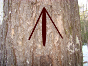
So what was known as the Act of 1729 was the cause of future trouble. That act said that in any township now laid out or to be laid out in Maine, the Surveyor of Pines and Timber should mark as property of the Crown such pines of more than 24 inch diameter as he should deem fit for Naval masts.
To the Maine colonists for whom lumbering was a major, and in many instances, the only cash occupation, the great pines had many other uses. Every time a Maine settler went into the woods and saw every big pine marked with the King’s Broad Arrow, his resentment increased. That resentment, added to British treatment of Boston and the imposition of various taxes, brought on the Revolution.
Originally Maine was covered in forests, with the modest exception of wild grasses that provided hay for the lumbermen’s horses. In reality, there were two forests. In the south, below a line from Gorham, New Hampshire to Bangor (the “Queen City” during the lumber boom), were the pines that thrived in the low, flat, sandy soils. Further north, red spruce, other conifers, and hardwoods shared the land with the pines.
In Richard Wood’s words, “Pine was the prince of the forest,” especially before the Civil War. The four species found in the state are the White, the Red or Norway, Pitch, and the Jack or Gray Pine (not common here). By mid-century, spruce was beginning to compete with pine for the lumber trade, though it would not be until later in the century that spruce began to dominate.
As William Cronin notes:
The first sawmills in Maine had been established in the early 1630s, but it was not until after mid-century that the northern lumbering industry came into its own. By 1682 there were twenty-four sawmills operating at the sites of present day Kittery, Wells, and Portland, shipping principally softwood lumber which, unlike hardwood, would float on the navigable streams flowing down to the coast.
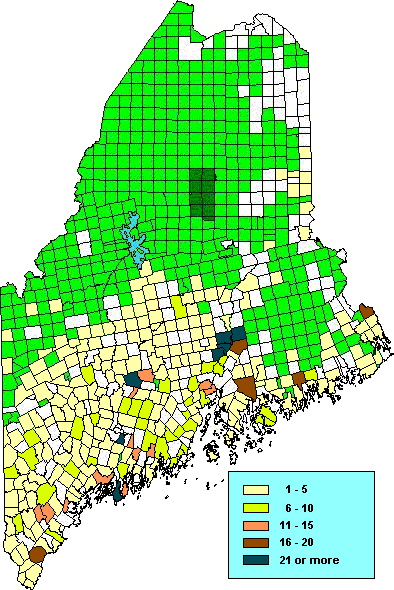
Sawmills in 1840 were most densely packed in the adjacent communities of Bangor, Orono, Old Town, Milford, and Bradley. Another cluster was in Fairfield, Clinton, and Waterville. A third dominated the area of Topsham, Brunswick and Bath. While scattered from the New Hampshire border to Washington County, over 90 percent were located south of the northern boundaries of Old Town and Bradley.
Hemlock ranked third in importance, since its bark was used in the tanning industry. In 1860 tanneries were located primarily in these counties (using the boundaries of 2003): Franklin, Androscoggin, Kennebec, and the southern portions of Somerset, Piscataquis and Penobscot counties.
In addition to its trees and good transportation, in the early 19th century Maine’s lumbering industry had another key advantage: a market – Boston – that was just then becoming industrialized.
The lumbering “frontier” in the State moved eastward and northward from river to river. Though a sawmill was established in York in the 1630’s, Indian resistance slowed expansion. By 1800 the Saco River hosted seventeen sawmills. After jumping to the Presumpscot, lumbermen established a major presence along the Androscoggin River valley by 1822. Not long afterwards, the Kennebec then the Penobscot rivers became the dominant centers of the industry.
The “peavey” was invented in 1858 by Maine native Joseph Peavey, a blacksmith at Stillwater near Old Town. It was intended to improve the work of the river drivers as they attempted to move and separate logs heading to a sawmill.
By 1860 he was manufacturing the pole with a sharp “pick” at the end and a hook (or dog) to grab a log to turn or control it. The items below are pick poles, the topmost has a simple “pick,” the other is a “pick and hook” design.
Maine was never the top producing state, as measured by board-feet. Though early records are not clear, the state was in the top three at mid-century. From 1899 through 1920 it’s rank ranged from 13 to 21, mostly between 16th and 19th.
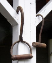
These “pulp hooks” were, and still are, used to maneuver the relatively short pulp logs into position on stacked piles or trucks. The one at right is a common design; the other is a lighter version.
Additional resources
Barry, William David ans Frances W. Peabody. Tate House: Crown of the Maine Mast Trade. Portland, Me. National Society of Colonial Dames of America in the State of Maine. 1982.
Chaney, Michael P. White Pine on the Saco River: An Oral History of River Driving in Southern Maine. Orono, Me. Maine Folklife Center. c1993.
Cronin, William. Changes in the Land: Indians, Colonists, and the Ecology of New England. New York. Hill and Wang. 1983. p. 110.
Hafford, Faye O’Leary. Beans and Biscuits: Tales of the Lumber Camps. Madawaska, Me. Valley Publishing Co., 1995.
McNair, Wesley. “”Little Talks #1097, October 24, 1976.” Waterville, Me. Colby College Special Collections. February 14, 2011. http://web.colby.edu/specialcollections/2011/02/14/lt1097-readonly/ (accessed January 4, 2013) [Text is condensed from the broadcast transcription.]
Sabine, Lorenzo. The Forest Lands of Maine: Report of the Land Agent of the Commonwealth of Massachusetts, laid before the Legislature, January 10th, 1844. 1844. [University of Maine, Raymond H. Fogler Library, Special Collections; Maine State Library]
Shawmut Manufacturing Company. Records, 1913 Dec. 1-1924 July 1. (Cataloger Note: A ledger of a lumber company in Maine listing trial balances beginning Dec. 1, 1913. The Shawmut Manufacturing Company in Fairfield, Maine was chartered December 24, 1904. It owned mill buildings and water rights and manufactured dimension lumber but specialized in such items as pine clapboards. The area where the Shawmut Manufacturing Company was located changed its name to Shawmut in honor of the new company.) [University of Maine, Raymond H. Fogler Library, Special Collections]
Smith, David C. A History of Lumbering in Maine, 1861-1960. Orono, Me. University of Maine Press. 1972.
Spencer, David M. A Legal History of the Maine Lumber Industry’s use of Rivers and Streams in the Nineteenth Century. 1981. (INDEPENDENT WRITING PROJECT (J.D.)–University of Maine School of Law, 1982.) [University of Maine School of Law. Garbrecht Law Library]
Stanley, Robert Dana. The Rise of the Penobscot Lumber Industry to 1860. 1963. [Thesis (M.A.) in History–University of Maine at Orono.]
Wood, Richard G. A History of Lumbering in Maine 1820-1861. Orono: University of Maine. 1935. pp. 20, 29.
*Map based on Wood’s version, with dots indicating each sawmill. This color-coded version is transposed on civil division boundaries as of 2003.


