
Location Map for Litchfield
| Year | Population |
|---|---|
| 1970 | 1,222 |
| 1980 | 1,954 |
| 1990 | 2,650 |
| 2000 | 3,110 |
| 2010 | 3,624 |
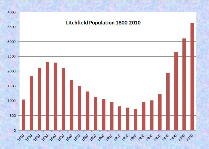
Population Trend 1800-2010
| Geographic Data | |
|---|---|
| N. Latitude | 44:09:28 |
| W. Longitude | 69:56:24 |
| Maine House | District 82 |
| Maine Senate | District 22 |
| Congress | District 2 |
| Area sq. mi. | (total) 39.7 |
| Area sq. mi. | (land) 37.4 |
| Population/sq.mi. | (land) 96.9 |
| County: Kennebec
Total=land+water; Land=land only |
|
")
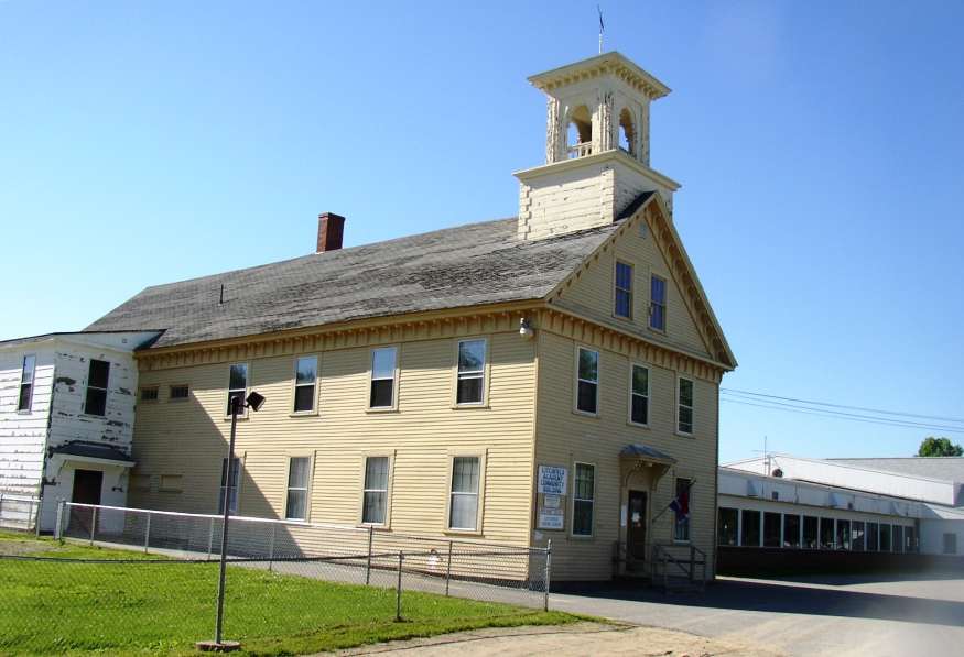
Academy Building Bell Tower
")
Academy Community Building
")
Congregational Church (2005)
[LICH-field] is a town in Kennebec County incorporated on February 18, 1798 from Smithfield Plantation. Its original large area was diminished between 1817 and 1867 as it ceded land to Bowdoinham, Kennebec (now Manchester), Wales, Webster and West Gardiner. [click images to enlarge]
In 1776 or 1777 Eliphalet Smith brought his family to make the first settlement. The trip, made in January overland from Topsham, took two days with four two-ox teams. The first Congregational Church, organized in 1811 and erected a larger building in 1824. In 1845 it was moved across the road and enlarged. That one was replaced in 1863 by a larger, more elaborate church across the street from the old Litchfield Academy.
Hiram Shorey (1862-1944) was born in the Plains section of Litchfield on the farm of his mother’s father, Stephen Purinton, who was a minister at the Plains Baptist Church. He was a merchant tailor in Chicago and New York, and one of the four founding members of Rotary International.
 N44° 8' 57.12\" W69° 55' 33.53\"")
Shorey Homestead Sign (2005) @
 N44° 8' 57.10\" W69° 55' 33.63\"")
Home of Hiram Elmer Shorey (2005) @
The historical society’s home was once Litchfield’s town house, built in 1840. After the new town office was occupied in 1973, the historical society was created and a museum in the historic building was initiated.
 N44° 9' 9.93\" W69° 56' 23.86\"")
Litchfield Plains Baptist Church (2014) @
")
Litchfield Historical Society (2005)
Litchfield Academy began classes in 1840 as a private tuition-based school on the Congregational Meetinghouse. Using an 1849 grant from the State of Maine, the Academy built its own school, which survives today. When free high schools came into existence, the town agreed to pay the Academy for four years of schooling. With dwindling enrollments, the school closed in 1960. It now serves as a community center.
 N44° 11' 54.41\" W69° 56' 38.53\"")
Dock on Woodbury Pond (’12)@

Red Admiral Butterfly (2007)
The town contains the Tacoma Lakes, Cobbosseecontee Stream, a portion of Cobbosseecontee lake, Pleasant Pond, Woodbury Pond (site of the butterfly) and several other ponds.
Route 197 in the south travels west from Litchfield Corners to another crossroads with West Road and Ferrin Road.
Libby Tozier School and Carrie Ricker Middle School are on Route 197 between the two “corners.”
")
Litchfield Tavern (2005)
")
Town Office (2005)
Located between Lewiston and Augusta on Maine combined Route 9 and 126, it offers summer cottage locations for many area residents. Without a traditional downtown, Litchfield Corners, in the southern tip of the community, located on the east-west Maine Route 197, is the closest it comes to having a village. Both the tavern and the new town office, along with a country store, are located at the Corners.
 N44° 8' 6.88\" W69° 58' 51.80\"")
Percy’s Hardware Co. on Route 197 (2014) @
 N44° 7' 52.73\" W70° 3' 55.11\"")
Convenience Store and Gas Pumps on Route 197 (’14) @
 N44° 8' 7.13\" W69° 58' 51.58\"")
Route 197 Diner in Litchfield (2014) @
 N44° 7' 58.81\" W69° 58' 17.38\"")
Carrie Ricker Middle School in Litchfield (2014) @
 N44° 9' 16.91\" W69° 56' 46.13\"")
Litchfield Fire/Rescue Central Station (2014) @
 N44° 8' 41.72\" W69° 53' 3.13\"")
Pleasant Pond on Litchfield-Richmond Line (2014) @
 N44° 9' 9.86\" W69° 56' 22.94\"")
Litchfield Veterans Memorial at the Plains (2014) @
 N44° 9' 11.05\" W69° 56' 28.76\"")
Buildings at the Litchfield Fair Grounds (2012) @
Form of Government: Town Meeting-Select Board-Manager.
Additional resources
Chadbourne, Ava Harriet. Maine Place Names and The Peopling of its Towns.
Clason, Oliver Barrett. History of Litchfield and an Account of its Centennial Celebrations, 1895. (1897) Bowie, MD. Heritage Books. 1992. With a new preface by David Colby Young.
Dunstan, William A. A History of the Kendall Memorial Chapel, Litchfield, Maine. W. A. Dunstan. 2003.
Historical Society of Ltichfield Maine. http://www.historicalsocietyoflitchfieldmaine.org/
Kingsbury, Henry D. “Town of Litchfield.” New York. H. W. Blake & Co. 1892. Extracted from: Ilustrated History of Kennebec County. Editors Henry D. Kingsbury, Simeon L. Deyo.
Litchfield Heritage Committee. Litchfield Yesterdays: A Short Historical Tour and Glimpse of Bygone Days. Litchfield, Maine. Litchfield Bicentennial Committee. 1976.
Parker, James Hill. Social History and the Dynamics of Belief. Lanham, MD. University Press of America. 1994.
Smith, Asa P. History of the Congregational Church of Litchfield, Maine. 1911.
Smith, John. Letter written by John Smith of Litchfield describing the first settlement of Litchfield. 1846. [Maine State Library Special Collections, original and copies.]
In the summers of 1956 and ’57 I attended Camp Tacoma Pines. Does anyone have much of the history of the camp? I didn’t pay much attention when I was there, but what was the body of water on which the camp was located?