
Location Map for Lagrange
| Year | Population |
|---|---|
| 1970 | 393 |
| 1980 | 509 |
| 1990 | 557 |
| 2000 | 747 |
| 2010 | 708 |
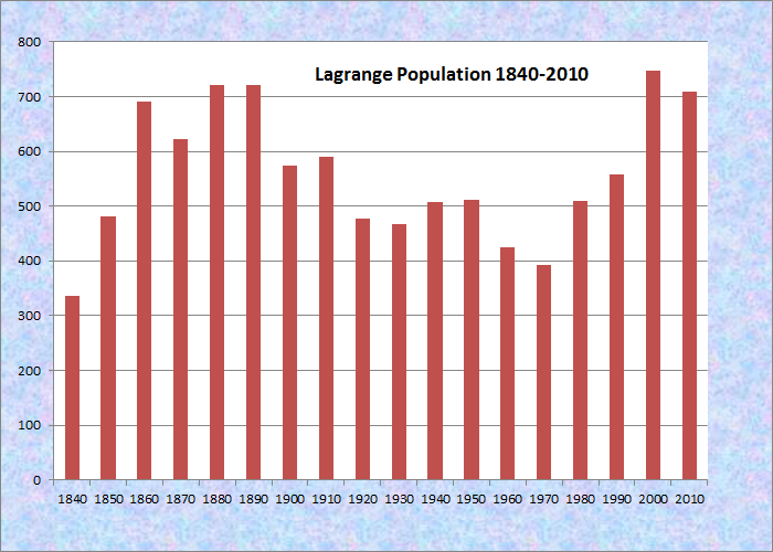
Population Trend 1840-2010
| Geographic Data | |
|---|---|
| N. Latitude | 45:09:59 |
| W. Longitude | 68:48:34 |
| Maine House | District 137 |
| Maine Senate | District 4 |
| Congress | District 2 |
| Area sq. mi. | (total) 49.5 |
| Area sq. mi. | (land) 49.4 |
| Population/sq.mi. | (land) 14.3 |
County: Penobscot
Total=land+water; Land=land only |
|

Medal of Honor
Congressional Medal of Honor recipient: Civil War
ABIATHER J. KNOWLES
") [Lah-GRANJ] is a town in Penobscot County, incorporated on February 11, 1832 from Hammond and Oxford Plantations.
[Lah-GRANJ] is a town in Penobscot County, incorporated on February 11, 1832 from Hammond and Oxford Plantations.
Prior to 1820 John Bennoch of Orono conducted logging in the area.
")
General Store at Crossroads
The first white settlement occurred in 1822 when John Freeze and others moved in.
Bennoch Road, Maine Route 16, runs the length of the town, north-south.
")
Houses Along Route 16 (2005)
Here is sketch by George Varney of the town’s economy in the 1880’s. At the time, Lagrange’s population of 721, in 1880, was close to its recent count of 708.
The soil is fertile, yielding excellent crops of hay, oats, wheat, corn and potatoes. The underlying rock is slate in many places. Dead Birch and Hemlock streams each have water-powers.
There are two saw-mills, manufacturing long and short lumber and fruit boxes and a grist mill. One of the saw-mills is driven by steam. Four trains [on the Bangor and Piscataquis Railroad] pass daily through the village.
")
Active Church (2005)
")
Old Abandoned Church (2005)
While growing slowly, this still small community retains its rural, farming and home town identity.
Lagrange was named for the estate of the Marquis de La Fayette, the French friend of the American Revolution.
")
Lagrange Post Office (2005)
")
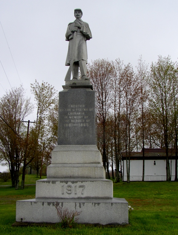
Veterans Memorial (2005)
")
Large Working Farm (2005)
A section of Maine Public Reserved Land is in the southwest corner of the township. Here are some excerpts, slightly edited, from the 2013 “Central Penobscot Region Draft Plan” for the area:
Thanks to the 2012 public acquisition of the south end of Seboeis Lake, unfettered access to nearly the entire shoreline is now possible. . . . Motorized recreationists on snowmobiles and ATVs can benefit from the multi-use trail in Millinocket and points south to the Bradford/LaGrange Parcel by using 12 miles of connector trail in the Seboeis Lake Unit.
The Bradford/LaGrange Public Lot is comprised of approximately 2,010 acres located in Bradford, LaGrange, and Orneville Townships. 1,179 of the acreage is in LaGrange and is accessed via the South LaGrange Road at the south end of the lot.
It was owned by forest industry until 1985 and has been managed by the state since then. Harvesting by the state has been comparatively light and selective, with retention of much structural diversity.
Of particular note is the presence of several healthy, medium sized (16”+) American chestnut trees on the property, as well as a number of seedlings and saplings. Mature chestnuts are rare in Maine, and the Bureau’s forest managers seek to retain them and promote regeneration where possible.
Form of Government: Town Meeting-Select Board.
Additional resources
Chadbourne, Ava Harriet. Maine Place Names and The Peopling of its Towns.
Maine. Department of Agriculture, Conservation and Forestry. “Central Penobscot Region Draft Plan. ” Augusta, Me. November 6, 2013. https://www.maine.gov/dacf/parks/get_involved/planning_and_acquisition/management_plans/docs/central_penobscot_resource_ior.pdf (accessed March 17, 2013)
Sawtell, Bill, Josephine Blake Bail, and others, eds. Old LaGrange. Greenville, Me. Moosehead Communications. 2003.
The Town Crier [newspaper]. 1963 Feb. 28-1976 Feb. 12. Mile, Me. Milo Printing Company. (Cataloger Note: A weekly news magazine serving the Maine towns of Brownville, Brownville Junction, LaGrange, Milo, Sebec.) [University of Maine, Raymond H. Fogler Library, Special Collections]
Varney, George J. A Gazetteer of the State of Maine. 1886. pp. 309-310.