
Location Map for Hammond
| Year | Population |
|---|---|
| 1970 | 73 |
| 1980 | 73 |
| 1990 | 93 |
| 2000 | 98 |
| 2010 | 118 |
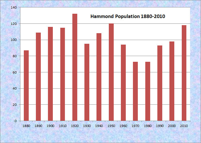
Population Trend 1880-2010
| Geographic Data | |
|---|---|
| N. Latitude | 46:14:11 |
| W. Longitude | 67:57:28 |
| Maine House | District 145 |
| Maine Senate | District 2 |
| Congress | District 2 |
| Area sq. mi. | (total) 39.1 |
| Area sq. mi. | (land) 38.9 |
| Population/sq.mi. | (land) 3.0 |
County: Aroostook
Total=land+water; Land=land only |
|
[HAM-mund] is a town in Aroostook County, organized on November 21, 1885 from the township Letter B R2, had its organization confirmed on March 5, 1895.
It was incorporated as a town in 1977.
Hammond is west of Littleton and northwest of Houlton in southern Aroostook County, clearly “off the beaten path” of U.S. Route 1, which serves those two communities. However, it has sustained, and increased, its small population over four decades.
B stream runs west to east through the southern portion of the township, from B Pond through B Dam in the east.
A section of Maine’s Public Reserved Lands, the “Hammond Lot,” is in the northwestern portion of the town. Access is through the small village in the southeast near Houlton.
The Burnt Brow Road leads through the village to the unimproved Bubar Road, which passes near the lot.
Form of Government: Town Meeting-Select Board-Administrator.