in Maine have been relatively mild since the reported “big one” on November 18, 1755, which was felt widely across New England and did great damage in Massachusetts. On April 20, 2002 people in Maine felt their houses shaking at 6:50 a.m. when a quake measuring 5.1 on the Richter scale struck, the strongest in the Adirondack region since 1983.
Maine has historically had a low but steady rate of earthquakes. According to the Maine Geological Survey, “No significant amount of motion has been shown for any fault since the last Ice Age, about 20,000 years ago, and geologic evidence demonstrates that many faults have been inactive since the formation of the Appalachians, over 300,000,000 years ago.”
The largest earthquake recorded in Maine between 1747 and 1992 was near Eastport in 1904. The largest accurate measurement was on June 15, 1973 from an earthquake just on the Quebec side of the border from northern Oxford County, with a Richter magnitude of 4.8. Most Maine quakes are of small magnitude; many, too small to feel. No Maine earthquake has caused significant damage. One expert, according to the Geological Survey, has estimated the return times for earthquakes of 4.6 magnitude in Maine to be 24 years.
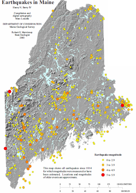
Earthquakes have been reported from all counties, indicating some level of statewide exposure. However both modern and historical records indicate somewhat higher activity in the eastern, central, and southwestern parts of the State (see activity map). The largest reported Maine earthquakes have caused some damage to property near the epicenter, such as damaging chimneys and breaking glass.
Most Maine buildings, such as unreinforced brick and masonry structures, were not built to withstand the effects of a significant (magnitude 6 or higher) earthquake.
The record of 507 historical and modern earthquake events has been compiled by the Maine Geological Survey for the years 1747 to 1992. The areas of relatively higher seismic activity include the Passamaquoddy Bay area of eastern Washington County; the Dover-Foxcroft – Milo area of southern Piscataquis County; and southwestern Maine in general, particularly the Portland-Lewiston region of Androscoggin and Cumberland Counties. The boundaries of these areas of higher activity are not clearly defined, and minor earthquake activity has been scattered across most areas of the State (see location map).
The largest earthquakes recorded in Maine are from the historical record, though for most of them the magnitude was not measured.
Earthquakes from Historical Record (1800-1975) with Significant Intensity
| Year | Place | Comments |
| 1904 | Eastport area | Largest earthquake in Maine |
| 1869 | Passamaquoddy Bay? | Location of epicenter uncertain, may have been in Bay of Fundy or in Eastport area. |
| 1857 | Lewiston | |
| 1905 | Sabattus | |
| 1912 | Eastport | |
| 1918 | Bridgton/Norway | magnitude 4.5 |
| 1928 | Milo | magnitude 4.5 |
| 1957 | Portland | magnitude 4.2 |
| 1973 | Bowmantown Twp. | magnitude 4.8 |
The most significant Maine earthquakes in the modern record have not caused much damage, but have been widely felt throughout the State. The strongest, in 1904, overthrew chimneys in Washington County, in the area of Calais and Eastport, Maine, and at St. Stephen, New Brunswick. Felt throughout most of New England and the Provinces of New Brunswick and Nova Scotia. It was observed west to the Hudson River and Montreal, Canada, and south to southern Connecticut. (U.S. Geological Survey).
Videos!
Significant Maine Earthquakes from the Modern Record (1975-2012)
| Date |
Place | Magnitude |
| Apr. 17, 1979 | Bath | 4.0 |
| May 29,1983 | Dixfield | 3.9 |
| Jan. 19, 1984 | Machias | 3.8 |
| Dec. 28, 1988 | Albion | 4.0 |
| Sept. 15, 1994 | Springfield | 3.9 |
| Feb. 25, 1999 | Winslow-China | 3.7 |
| Oct. 2, 2006 | Gouldsboro area** | 3.8 |
| Oct. 16, 2012 | Waterboro*** | 4.5 |
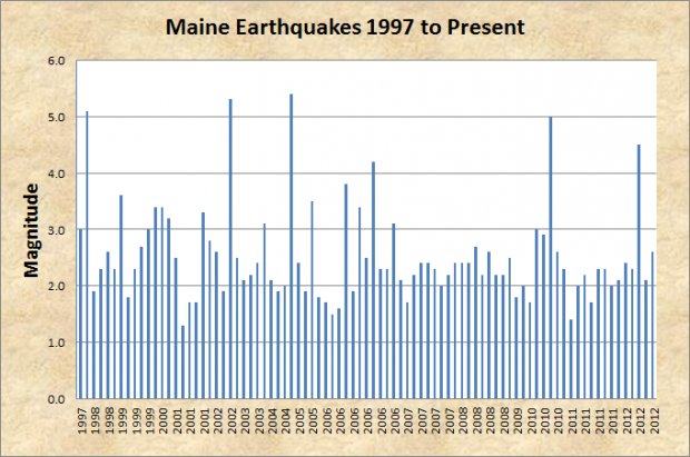
The following is a more comprehensive account of earthquakes beginning in 1997, including some with a magnitude of 2.0 or less, which are considered relatively minor.

| Date | Mag | Notes | Location |
| 29-Apr-97 | 3.0 | MN | near Wilton (central Maine) |
| 5-Nov-97 | 5.1 | MN* | near Quebec City, Canada (felt widely across Maine) |
| 7-Jun-98 | 1.9 | MN | about 12 miles southwest of Fish River Lake (northern Maine) |
| 5-Sep-98 | 2.3 | MN | near Sedgwick (mid-coast Maine) |
| 16-Sep-98 | 2.6 | MN | near West Pembroke (eastern Maine) |
| 1-Jan-99 | 2.3 | MN | Perry-Quoddy area, Passamaquoddy Bay |
| 25-Feb-99 | 3.6 | MN | approx. 7 miles southeast of Waterville |
| 9-Jun-99 | 1.8 | MN | east of Petit Manan (offshore) |
| 4-Jul-99 | 2.3 | MN* | approx. 20 miles southeast of Cutler (offshore) |
| 27-Jul-99 | 2.7 | MN | approx. 30 miles south of Allagash |
| 24-Dec-99 | 3.0 | MN | Newport-Etna area |
| 3-Jan-00 | 3.4 | MN | Turner-Livermore area |
| 17-Jan-00 | 3.4 | MN | approx. 10 miles north of Rumford |
| 7-Sep-00 | 3.2 | MN | approx. 15 miles southeast of Waterville |
| 20-Jan-01 | 2.5 | MN | approx. 8 miles northwest of Machias |
| 1-Jul-01 | 1.3 | MN | approx. 2 miles southwest of Bucksport |
| 13-Jul-01 | 1.7 | MN | approx. 5 miles south of Dover-Foxcroft |
| 14-Jul-01 | 1.7 | MN | approx. 4 miles north of Harmony |
| 24-Oct-01 | 3.3 | MN | approx. 2 miles south of Howland |
| 27-Dec-01 | 2.8 | MN | approx. 35 miles northeast of Bangor |
| 25-Feb-02 | 2.6 | MN | about 4 miles southwest of Bucksport |
| 15-Mar-02 | 1.9 | MN | near Brownville Junction (central Maine) |
| 20-Apr-02 | 5.3 | MN* | near Plattsburgh, New York |
| 11-May-02 | 2.5 | MN | approx. 12 miles northeast of Newport (central Maine) |
| 11-Feb-03 | 2.1 | MN | approx. 13 miles north of Dover-Foxcroft |
| 15-Mar-03 | 2.2 | MN | Limington-Standish area, southern Maine |
| 22-Aug-03 | 2.4 | MN | between Waterville and Augusta |
| 15-Oct-03 | 3.1 | MN* | approx. 11 miles east of Robbinston, Passamaquoddy Bay |
| 16-Mar-04 | 2.1 | MN | Cape Neddick area (offshore) |
| 29-Mar-04 | 1.9 | MN | felt in Hallowell, Farmingdale (<2.0?) |
| 22-Jun-04 | 2.0 | MN | approx. 6 miles northeast of Dover-Foxcroft |
| 6-Mar-05 | 5.4 | MN* | northeast of Quebec City, Canada (felt widely across Maine) |
| 11-May-05 | 2.4 | MN | approx. 6 miles northeast of Dover-Foxcroft |
| 14-Aug-05 | 1.9 | MN | China Lake region, northeast of Augusta (poorly located) |
| 25-Sep-05 | 3.5 | MN | approx. 8 miles northwest of Pembroke, Washington Co. |
| 20-Jan-06 | 1.8 | MN | approx. 6 miles southeast of Dover-Foxcroft |
| 20-Jan-06 | 1.7 | MN | approx. 13 miles southeast of Dover-Foxcroft |
| 29-May-06 | 1.5 | MN | approx. 7 miles southeast of Dover-Foxcroft |
| 31-May-06 | 1.6 | MN* | approx. 23 miles southeast of Machias (offshore) |
| 14-Jul-06 | 3.8 | MN | about 15 miles northwest of Portage, central Aroostook Co. |
| 5-Aug-06 | 1.9 | MN | approx. 6 miles west of Byron, western Maine |
| 22-Sep-06 | 3.4 | MN | east of Cadillac Mountain, Mount Desert Island |
| 28-Sep-06 | 2.5 | MN | east of Cadillac Mountain, Mount Desert Island |
| 2-Oct-06 | 4.2 | MN | east of Cadillac Mountain, Mount Desert Island |
| 22-Oct-06 | 2.3 | MN | east of Cadillac Mountain, Mount Desert Island |
| 18-Dec-06 | 2.3 | MN | east of Cadillac Mountain, Mount Desert Island |
| 29-Dec-06 | 3.1 | MN | east of Cadillac Mountain, Mount Desert Island |
| 1-Feb-07 | 2.1 | MN | approx. 5.5 miles southwest of Augusta |
| 26-Feb-07 | 1.7 | MN | approx. 7 miles north-northwest of Ellsworth |
| 4-Mar-07 | 2.2 | MN* | about 10 miles east-southeast of Isle Au Haut (offshore) |
| 16-Jul-07 | 2.4 | MC | Lewiston |
| 2-Oct-07 | 2.4 | MC | Topsham, about 3 miles northwest of Brunswick |
| 2-Oct-07 | 2.3 | MC | Lexington Township, about 22 miles northwest of Skowhegan |
| 9-Oct-07 | 2.0 | MN | Andover, about 12 miles northwest of Rumford |
| 11-Dec-07 | 2.2 | MN | Topsham, about 5 miles northwest of Brunswick |
| 19-May-08 | 2.4 | MC | Presque Isle |
| 30-May-08 | 2.4 | MC | Flanders Bay, about 7 miles northeast of Bar Harbor |
| 22-Aug-08 | 2.4 | MC | Mount Vernon, about 14 miles northwest of Augusta |
| 30-Aug-08 | 2.7 | MC | Wilton, about 5 miles southwest of Farmington |
| 24-Oct-08 | 2.2 | MC | Exeter, about 6 miles east of Corinna |
| 25-Oct-08 | 2.6 | MC | Livermore, about 21 miles north of Lewiston |
| 13-Nov-08 | 2.2 | MN | Newry, about 10 miles west of Rumford |
| 24-Dec-08 | 2.2 | MN | Clinton, about 10 miles northeast of Waterville |
| 19-Nov-09 | 2.5 | MN | South Andover, about 6 miles northwest of Rumford Center |
| 7-Dec-09 | 1.8 | MN | Gardiner |
| 2-Feb-10 | 2.0 | MN | about 8 miles southeast of Masardis (northwest of Houlton) |
| 17-Feb-10 | 1.7 | MN* | offshore of Trescott Township, about 14 miles south-southwest of Eastport |
| 30-Mar-10 | 3.0 | MN | near Orrington-Bucksport line, about 7 miles north of Bucksport |
| 7-Jun-10 | 2.9 | MN* | offshore, about 11 miles southeast of Boon Island (York County) |
| 23-Jun-10 | 5.0 | MN* | Canada, about 35 miles north-northeast of Ottawa. Felt in southwestern Maine. |
| 29-Jul-10 | 2.6 | MN | Northfield, about 12½ miles northwest of Machias |
| 29-Aug-10 | 2.3 | MN | Hollis, about 9 miles west of Gorham |
| 17-Jan-11 | 1.4 | MN | Waldo, about 3 miles northwest of Belfast |
| 31-Jan-11 | 2.0 | MN | near South Robbinston, about 11 miles north-northwest of Eastport |
| 25-Mar-11 | 2.2 | MN | Burlington, about 9 miles southeast of Lincoln, central Maine |
| 30-Apr-11 | 1.7 | MN | Bucksport – Searsport area, microquake swarm – April 30- May 5, 2011, 1.7 and less |
| 7-Jul-11 | 2.3 | MN | Brooksville, about 4 miles east of Castine, mid-coast Maine |
| 12-Dec-11 | 2.3 | MN | Sedgwick, about 8 miles southeast of Castine, mid-coast Maine |
| 30-Dec-11 | 2.0 | MN | 12 miles south-southeast of Allagash, northern Maine |
| 16-Jan-12 | 2.1 | MN | 7 miles south-southeast of Allagash, northern Maine |
| 17-Feb-12 | 2.4 | MN | T18 ED BPP, 11 miles north of Machias, eastern Maine |
| 17-Feb-12 | 2.3 | MN | 12 miles north-northwest of Machias, eastern Maine |
| 16-Oct-12 | 4.5 | MN | East Waterboro, about 13 miles northwest of Saco |
| 23-Nov-12 | 2.1 | MN | North Searsmont, about 11 miles west of Belfast |
| 12-Dec-12 | 2.6 | MN | Waterboro, about 3.7 miles south of Lake Arrowhead |
The Maine Geological Survey provides advisory and interpretive information on earthquakes for planning and regulatory agencies. The New England Seismic Network maintains a network of seismic stations across New England that monitors, analyzes, and reports earthquake activity in Maine.
Additional resources
Henry N. Berry IV. “Earthquakes in Maine.” Maine Department of Conservation, Maine Geological Survey, Augusta, Maine. http://www.maine.gov/doc/nrimc/mgs/explore/hazards/quake/quake.htm (accessed November 13, 2010)
See http://www.maine.gov/doc/nrimc/mgs/pubs/online/quakes/quake11x17.pdf for more maps and a history of earthquakes in Maine.
**”Magnatude 3.8 – MAINE.” U.S. Geological Survey. http://earthquake.usgs.gov/earthquakes/eqinthenews/2006/ustib1/ (accessed November 13, 2010)
*** http://earthquake.usgs.gov/earthquakes/map/ (accessed October 17, 2012)
Perley, Sidney. Historic Storms of New England. Beverly, Massachusetts: Memoirs Unlimited. 2001. (Originally published in 1891)


