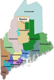
is home to Maine’s second largest population center – the Lewiston-Auburn area, and is fourth in overall population among Maine’s counties. It was established in 1854 by taking several towns from Cumberland, Kennebec, Lincoln, and Oxford counties. See an1858 map of the county in the Map Cabinet.
A commercial and industrial hub, it has been an attraction for Franco-American’s seeking work in its mills during the 19th century, and for Somali refugees from the violence of their war-torn country in the 20th century.

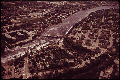
Androscoggin River flowing between Auburn (upper left) and Lewiston June, 1973. U.S. EPA National Archives #NWDNS-412-DA-8247
The Androscoggin River, which rises in New Hampshire, and the historic falls known to the Indians as Amitgonpontook, divide the two cities. Once rife with salmon, the river now has few due to pollution and a lack of fishways on dams in the 19th century.
The City of Auburn is the county seat, site of the superior court, the sheriff’s office, and other county offices. Lewiston, the larger of the two cities, hosts Bates College and its Edmund S. Muskie Archives.
Androscoggin County was formed by an act of the Maine Legislature in 1854, taking several towns from each of Cumberland, Lincoln and Oxford counties.
Over the following thirteen years it gained additional towns from Cumberland and Kennebec counties. It lost one town when Danville was absorbed into Auburn in 1867 and gained one when Mechanic Falls was created out of portions of Minot and Poland in 1893.
In 2011 it contained the following: the cities of Auburn and Lewiston; and the towns of Durham, Greene, Leeds, Lisbon, Livermore, Livermore Falls, Mechanic Falls, Minot, Poland, Sabattus, Turner and Wales.
National Register of Historic Places
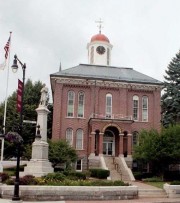
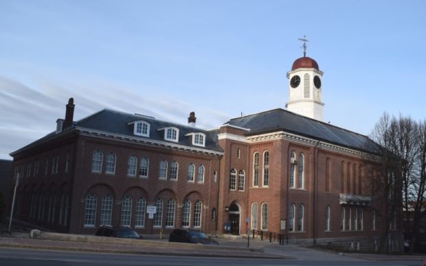
Androscoggin County Courthouse and Jail
[2 Turner Street] This impressive landmark on the main street is a finely detailed Renaissance Revival structure. At completion it also marked the culmination of the long struggle to establish Androscoggin as a new county made up of towns from four adjoining counties.
The controversy was a stormy one and more contentious was the location of its shire town. When Auburn was finally selected in 1854, plans for the court house were hastened so that when it was completed in 1857 it stood as a symbol of the final settlement of the dispute.*
| People QuickFacts | Androscoggin County | Maine | |
|---|---|---|---|
| Population, 2009 estimate | 106,539 | 1,318,301 | |
| Population, percent change, April 1, 2000 to July 1, 2009 | 2.6% | 3.4% | |
| Population estimates April 1, 2000 | 103,793 | 1,274,915 | |
| Persons under 5 years old, %, 2009 | 6.3% | 5.4% | |
| Persons under 18 years old, %, 2009 | 22.0% | 20.6% | |
| Persons 65 years old and over, percent, 2009 | 14.8% | 15.6% | |
| Female persons, percent, 2009 | 51.2% | 51.2% | |
| White persons, percent, 2009 (a) | 95.3% | 96.1% | |
| Black persons, percent, 2009 (a) | 2.2% | 1.2% | |
| American Indian and Alaska Native persons, %, 2009 (a) | 0.4% | 0.6% | |
| Asians %, 2009 (a) | 0.7% | 1.0% | |
| Native Hawaiian and Other Pacific Islander, %, 2009 (a) | Z | Z | |
| Persons reporting two or more races, percent, 2009 | 1.4% | 1.1% | |
| Persons of Hispanic or Latino origin, percent, 2009 (b) | 1.8% | 1.4% | |
| White persons not Hispanic, percent, 2009 | 93.7% | 94.9% | |
| Living in same house in 1995 and 2000, pct 5 yrs old & over | 56.7% | 59.6% | |
| Foreign born persons, percent, 2000 | 2.6% | 2.9% | |
| Language other than English spoken at home, pct age 5+, 2000 | 16.4% | 7.8% | |
| High school graduates, percent of persons age 25+, 2000 | 79.8% | 85.4% | |
| Bachelor’s degree or higher, pct of persons age 25+, 2000 | 14.4% | 22.9% | |
| Persons with a disability, age 5+, 2000 | 21,484 | 237,910 | |
| Mean time to get to work (minutes), workers age 16+, 2000 | 23.3 | 22.7 | |
| Housing units, 2009 | 48,655 | 704,578 | |
| Homeownership rate, 2000 | 63.4% | 71.6% | |
| Housing units in multi-unit structures, percent, 2000 | 35.6% | 20.3% | |
| Median value of owner-occupied housing units, 2000 | $89,900 | $98,700 | |
| Households, 2000 | 42,028 | 518,200 | |
| Persons per household, 2000 | 2.38 | 2.39 | |
| Median household income, 2008 | $44,484 | $46,419 | |
| Per capita money income, 1999 | $18,734 | $19,533 | |
| Persons below poverty level, %, 2008 | 13.1% | 12.6% | |
| Business QuickFacts | Androscoggin County | Maine | |
|---|---|---|---|
| Private nonfarm establishments, 2008 | 2,894 | 41,7551 | |
| Private nonfarm employment, 2008 | 46,539 | 509,0931 | |
| Private nonfarm employment, percent change 2000-2008 | 1.5% | 3.5%1 | |
| Nonemployer establishments, 2008 | 6,473 | 113,522 | |
| Total number of firms, 2002 | 8,162 | 135,410 | |
| Black-owned firms, percent, 2002 | F | 0.2% | |
| American Indian & Alaska Native owned firms, %, 2002 | F | 0.5% | |
| Asian-owned firms, percent, 2002 | F | 0.6% | |
| Native Hawaiian and Other Pacific Islander owned firms, percent, 2002 | F | S | |
| Hispanic-owned firms, percent, 2002 | F | 0.5% | |
| Women-owned firms, percent, 2002 | 24.0% | 24.0% | |
| Manufacturers shipments, 2002 ($1000) | 1,441,405 | 13,851,915 | |
| Wholesale trade sales, 2002 ($1000) | 451,541 | 10,371,084 | |
| Retail sales, 2002 ($1000) | 1,468,010 | 16,053,515 | |
| Retail sales per capita, 2002 | $13,951 | $12,370 | |
| Accommodation and foodservices sales, 2002 ($1000) | 112,811 | 2,045,841 | |
| Building permits, 2009 | 167 | 3,1211 | |
| Federal spending, 2008 | 737,991 | 11,974,3611 | |
| Geography QuickFacts | Androscoggin County | Maine | |
|---|---|---|---|
| Land area, 2000 (square miles) | 470.27 | 30,861.55 | |
| Persons per square mile, 2000 | 220.8 | 41.3 | |
| FIPS Code | 001 | 23 | |
| Metropolitan or Micropolitan Statistical Area | Lewiston-Auburn, ME Metro Area |
U.S. Census Table Notes: F=fewer than 100 firms; S=supressed, data does not meet publication standards; Z=greater than zero, but less than 1/2 percent; (a)=includes persons reporting only one race; (b)=Hispanics may be of any race, so also are included in applicable race categories.
Source: http://quickfacts.census.gov/qfd/states/23/23001.html (accessed February 23, 2011)
Additional resources
Androscoggin County (Me.). Board of County Commissioners. A Statement of the Financial Condition of the County of Androscoggin. Auburn, Me. The County. [various years]
Baker, Gregory. The Primary Wood Using Industries of Androscoggin and Sagadahoc Counties for the Year 1942. Orono, Me. Maine Agricultural Experiment Station. 1944.
D’Eramo, Andrew. Police Effectiveness in Androscoggin County. 2010. Thesis (M.A.)–University of Southern Maine, 2010.
Final Environmental Impact Statement on the Final 208 Waste Treatment Management Plan for the Androscoggin Valley Regionl Planning Commission. Prepared by Androscoggin Valley Regional Planning Commission [and] U. S. Environmental Protection Agency, Region I. Boston, Mass. The Agency. Auburn, Me. The Commission. [1978]
Fisher, Lloyd. W. “Structure and Metamorphism of Lewiston, Maine Region.” Extracted from: Bulletin of the Geological Society of America, v.52, January 1, 1941.
Lecompte, Nancy. Alnôbak: a Story of Indigenous People in Androscoggin County. Auburn, Me. Androscoggin Historical Society. 2003.
“Lewiston/Auburn Historical Walking Touring.” The Androscoggin Chamber of Commerce. http://www2.androscoggincounty.com/public/index.cfm?fuseaction=articles.view&id=4049 (accessed February 15, 2011)
*Maine. Historic Preservation Commission. Augusta, Me. See additional text and photos from National Register of Historic Places: http://pdfhost.focus.nps.gov/docs/nrhp/text/83003633.PDF, http://pdfhost.focus.nps.gov/docs/nrhp/photos/83003633.PDF
Merrill, Georgia Drew [ed.] History of Androscoggin County, Maine. Boston, Mass. W.A. Fergusson. 1891.
Tara, Kaileigh [ed.] Growing up in Androscoggin County: Some Facts You Should Know About the Children in our Community. Auburn, Me. Advocates for Children. [1991?]


