")

Location Map for Woolwich
| Year | Population |
|---|---|
| 1970 | 1,710 |
| 1980 | 2,156 |
| 1990 | 2,570 |
| 2000 | 2,810 |
| 2010 | 3,072 |
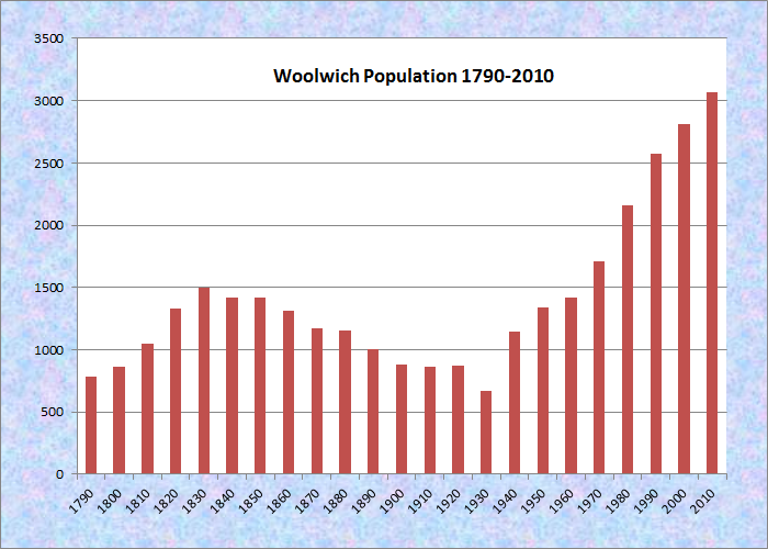
Population Trend 1790-2010
| Geographic Data | |
|---|---|
| N. Latitude | 43:57:58 |
| W. Longitude | 69:45:58 |
| Maine House | District 53 |
| Maine Senate | District 23 |
| Congress | District 1 |
| Area sq. mi. | (total) 41.7 |
| Area sq. mi. | (land) 35.1 |
| Population/sq.mi. | (land) 87.5 |
County: Sagadahoc
Total=land+water; Land=land only |
|
Woolwich Shore on the Kennebec River from Thorne Head in North Bath (2010)
[WOOL-itch or WOOL-wich] is a community in Sagadahoc County, incorporated on October 20, 1759 as a District, then on August 23, 1775 as a town named for Woolwich, England.
Settled in 1638, the area saw its share of tragedy and conflict with Indians. In the 1650’s a Mr. and Mrs. Preble and their small child were killed; two other children were taken captive in was became known as the “Preble Massacre.”
")
Woolwich Town Office and Fire Department (2003)
")
Woolwich Historical Society and Museum (2003)
In the early 1600’s a dam was built in Nequasset, now a portion of Woolwich. It was the early primary power source for the town, the site of grist, saw, and fulling mills. The original wooden fishway provided a rich harvest of alewives, which was apportioned among the residents according to their needs, with widows and older people given preference.

Site of the Alewife Fishway in Nequasset, Woolwich . . .
")
at Low and High Tides (2003)
Sir William Phipps, the first Royal Governor of Massachusetts, was born in 1651 in what is now Woolwich. Wilmot W. Brookings, active in the Dakota Territory in the 19th century, was born here in 1830.
")
Nequasset Congregational Church (2003)
")
Nequasset Congregational Church Interior (2003)
After their 1754 petition to separate from Georgetown was denied – “No house of Worship and no resident pastor” – the local population incorporated the Nequasset Congregational Church in 1759. It was the first Protestant church east of the Kennebec River. By 1761 town meetings were held in the church building. In 1773 the property was conveyed to the Town; then returned to the parishioners in 1877; and finally acquired by the Town again in 1987.
Earlier, the upkeep of the church building was paid by the town, though the pastor was paid from a separate church tax, which all families were require to pay.
 N43° 56' 36.25\" W69° 47' 56.34\"")
Leaving Days Ferry (2003) @
The Days Ferry area was the eastern terminal of the vessel Hockamock, which ferried passengers across the Kennebec River to Bath until the construction of the Carleton Bridge. That bridge, bringing U.S. Route 1 to points “Downeast,” was superseded by a wider higher structure in 2000.
")
Hathorne House (postcard)
The 1760 Robert White Tavern served travelers to Days Ferry until it was converted to a family home by J.W. Hathorne in the early 19th century.
Nequasset Brook, off the Stage Road, offers a pleasant short canoe trip into the woods and along meadows.
Woolwich is home to two nature preserves. The Montsweag Preserve is 45 acres of woods and ledge shoreline bordering tidal creek that empties into Montsweag Bay and is frequented by migrating waterfowl. A loop trail passes through woods, past tidal marsh and overlooking high shore. Approachable by land or by canoe along the estuary, it is managed by the Nature Conservancy.
 N44° 0' 20.15\"")
R. P. T. Coffin Wild Flower Sanctuary (’14) @
 N44° 0' 0.78\" W69° 48' 12.25\"")
North Woolwich Methodist Church (2005) @
The Robert P. Tristram Coffin Wildflower Sanctuary is a 180-acre preserve owned by the New England Wildflower Society and named for author R.P.T. Coffin, containing more than 200 species of flowers, grasses, trees and shrubs. The sanctuary, located on Route 128, just north of Chop Point Road, includes trails along Merrymeeting Bay.
")
West from Rt. 128 at Merrymeeting Bay (’03)
")
Tidal Wetland off U.S. Route 1 (2003)
Partridge Farm on the Joseph Mains Road maintains horses, alpacas and sheep in addition to a maple sugaring operation in the spring.
 N43° 58' 31.73\" W69° 48' 46.95\"")
Barn at Partridge Hill Farm (2014) @
 N43° 58' 31.22\" W69° 48' 47.13\"")
Alpacas at Partridge Hill Farm (2014) @
 N43° 58' 37.88\" W69° 49' 14.32\"")
Maple Sunday, Partridge Hill Farm (2014) @
Woolwich Historical Society on U.S. Route 1 features many items and images of the town’s history. The old Carleton Bridge maintains the railroad trestle below the road surface, now closed to automobiles.
")
Museum Exhibit (2003)
")
Bath-Woolwich Railroad Bridge (2002)
Form of Government: Town Meeting-Select Board-Administrator.
Additional resources
History of Woolwich, Maine: A Town Remembered. Woolwich, Me. Woolwich Historical Society. 1994. [University of Maine, Raymond H. Fogler Library, Special Collections; Maine State Library]
Leeman, Martha. A History of Woolwich, Maine from Discovery to 1860. 1948. (Thesis (Honors) in History–University of Maine, 1948) [University of Maine, Raymond H. Fogler Library, Special Collections]
*Maine. Historic Preservation Commission. Augusta, Me. Text and photos from National Register of Historic Places: http://pdfhost.focus.nps.gov/docs/nrhp/text/xxxxxxxx.PDF and http://pdfhost.focus.nps.gov/docs/nrhp/photos/xxxxxxxx.PDF
Days Ferry Historic District: 75000109.PDF
Hathorn, Lt. Richard, House: 80000251.PDF
Reed, Coffin House: 82000777.PDF
Woolwich Town House: 78000199.PDF
McCauley, Brian. The Names of Maine.
Thayer, Henry Otis. Loyalists of the Kennebec: and One of Them–John Carleton. Dover, Maine. Sprague’s Journal of Maine History. 1918. [Bangor Public Library; Maine State Library]
Thayer, Henry Otis. Town of Woolwich, Maine. New York. H.O. Thayer. 1924. [Maine State Library]
Wallace, Burnette Bailey. World of the Old Nequasset Meeting House. Woolwich, Me. Woolwich Historical Society. 1989. [Maine State Library]
Woolwich Historical Society. Hathorne House postcard printers.
National Register of Historic Places – Listings
 Days Ferry Historic District

[Routes 127 and 128] The pleasant village of Days Ferry lies on the eastern shore of the Kennebec River across from and about a mile above the City of Bath. It is intersected by State Highways 128 and 127 and a dead end road leads easterly from 128 in the center of the village. [see map]*
")
")
The village is basically unspoiled by modern intrusions. The district includes an area 200 yards either side of these roads and along the bank of the river where less than 200 yards from the road. The district includes all buildings or sites of historic or architectural merit.*
Reed, Robert, House (Robert P. Tristram Coffin Home)
")
[Maine Route 128 and Chop Point Road, Woolwich] The Robert Reed House in North Woolwich, built about 1765, is a beautifully restored example of a rural colonial homestead. The house is also important as the home, beginning in the 1930s, of Robert P. Tristram Coffin, Pulitzer Prize winning poet and author, while a professor at Bowdoin College. Coffin, sometimes referred to as Maine’s poet laureate, wrote fondly of the house in his book, Kennebec, Cradle of Americans: “My house on Merrymeeting Bay, where I write these lines, is only one among many places waiting to flower again by the river that runs through the heart of Maine. . . .”*
Hathorn, Lt. Richard, House
[Maine Route 127] This 1784 House is probably the best preserved early Federalstyle farmhouse in Maine’s central coastal region. It is virtually unchanged inside and out, except for modern plumbing. The large central chimney with its five fireplaces is intact; windows and doors are unchanged. The seven foot kitchen fireplace retains its “beehive oven” and original hearth. Panelling of unusual detail remains in all the principal rooms.
")
")
Built by Revolutionary War veteran Lieutenant Richard Hathorn, the house has been continuously occupied since construction.*
Woolwich Town House
[Old Stage and Dana Mills Roads; N43° 58′ 8.46″ W69° 46′ 9.90″] The Woolwich Town Hall, unaltered from its pristine spartan simplicity, survives as a classic example of rural public architecture in the first half of the 19th century. Built in 1837 by a vote of the town, it replaced the local meeting house as the site of town meetings and other non-religious gatherings.
The Town Hall was built with funds arising out of the distribution of the Federal surplus beginning in 1836. By 1835 the national debt was finally liquidated for the first time, but additional funds still poured into the federal Treasury. This revenue flowed principally from the customhouses that were benefiting from the high tariff duties and the heavy imports resulting from a boom In the economy.
In 1836 Congress passed a bill authorizing the distribution of the surplus above $5 million among the states. President Jackson, who had pocket vetoed a similar bill in 1833, approved the bill that became effective on January 1, 1837. The surplus was to be “deposited” with the states in proportion to the number of their representatives in both houses of Congress.
The deposit was supposedly subject to recall at the pleasure of the Secretary of the Treasury. The real intention was to make a present to the states, but the law provided for a deposit to satisfy the scruples of some Senators and Representatives who denied the constitutional rights of Congress to give away the public money.
The Maine Legislature voted that the money thus received be divided among the towns and plantations, according to population. The towns and plantations were permitted to use the money for any purpose for which money raised By taxation might be used or to loan on ample security.
")
 N43° 58' 8.46\" W69° 46' 9.90\"")
On September 11, 1837, the Town of Woolwich, in town meeting, voted to accept the money and ”That 800 Dollars of the surplus money be appropriated for building a town house.”*