
Location Map for Woodstock
| Year | Population |
|---|---|
| 1970 | 1,005 |
| 1980 | 1,087 |
| 1990 | 1,194 |
| 2000 | 1,307 |
| 2010 | 1,277 |
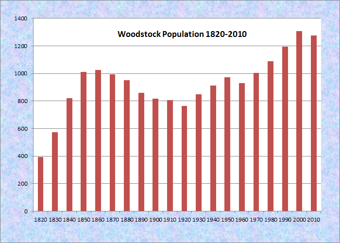
Population Trend 1820-2010
| Geographic Data | |
|---|---|
| N. Latitude | 44:23:15 |
| W. Latitude | 70:35:13 |
| Maine House | District 115 |
| Maine Senate | District 18 |
| Congress | District 2 |
| Area sq. mi. | (total) 46.9 |
| Area sq. mi. | (land) 45.7 |
| Population/sq.mi. | (land) 27.9 |
County: Oxford
Total=land+water; Land=land only |
|
")
Fryeburg Fair (2004)
Bryant Pond in Woodstock from Route 26 (2003)
[WOOD-stok] is a town in Oxford County, incorporated on February 7, 1815 from Dummer and Gorham Academy Grants townships. After exchanging land with Paris (1825, 1841), it annexed land from Milton Plantation (1853) and annexed all of Hamlin’s Grant Plantation (1873). In its final adjustments, Woodstock ceded land to Paris in 1880 and annexed some from Greenwood in 1893.
")
Grange and a Lodge Hall in Bryant Pond Village (2003)
")
South Woodstock Meetinghouse (2003)
Built about 1916, the substantial two-story, lakeside “summer cottage” Dreamhome was constructed by William Ellery and his wife Bessie. It was the centerpiece of a 125 acre estate bordering Lake Christopher and comprising several other cottages and outbuildings. The structure is a prime example of fine non-coastal summer residences in Maine’s lake shore interior.
")
Bryant Pond (2003)
")
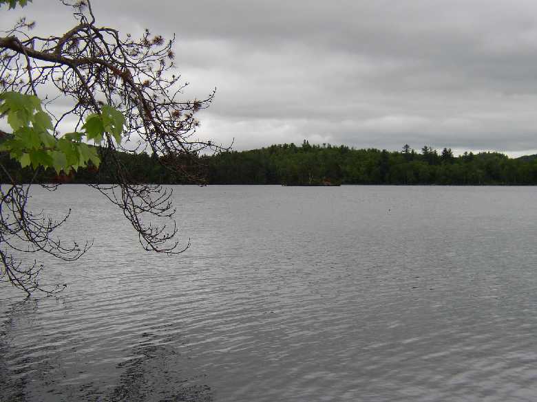
Moody Mountain across North Pond (2003)
Not the site of the 1960’s rock concert (that was New York), Woodstock’s major village is Bryant Pond, named from the adjacent water body.
The Pond outlet is the source of the Little Androscoggin River.
The town gained brief fame as the last telephone exchange in Maine to give up a human operator in favor of automation.
The old equipment has been on exhibit at the Fryeburg Fair. North Pond lives up to its name by its location in the northwest corner of the town.
")
Mill on Andrews Brook (2003)
")
Old Mill Pond (2003)
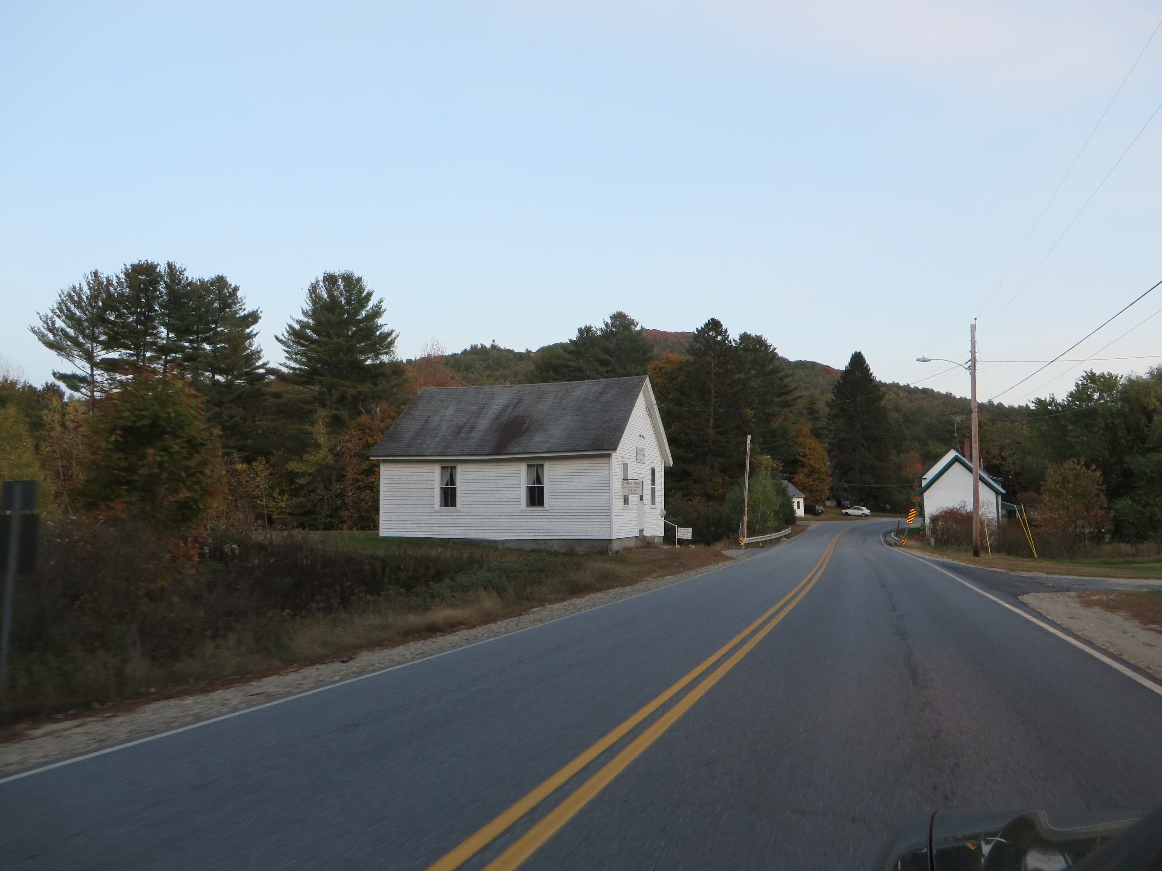
South Woodstock is home to the small South Woodstock Meetinghouse and is the site of an old mill pond and mill on Andrews Brook.
The town, served by Maine Routes 26 and 232, lies east of Bethel and north of West Paris.
Several small mountains are scattered throughout: Spruce (site of a wind farm) in the north, Mollyockett in the east, and Whitman in the southwest.
The town was the birthplace in 1819 of Sidney Perham, Maine Governor and member of Congress. Perham had also served as a member of the town’s board of selectmen while in his twenties.
North Woodstock Village on Route 232 (2014)

Pinhook Meetinghouse in No. Woodstock (’14) @
 Congressional Medal of Honor winner:
FRANK M. WHITMAN
Form of Government: Town Meeting-Select Board-Manager.
Additional resources
Bacon, Ralph M.. The Old Village of Woodstock, Maine: Known as Stephens’ Mills or Woodstock Corner. Bryant Pond, Me. Woodstock Chamber of Commerce. 1970.
Barnes, Diane. The Oxford Hills: Greenwood, Norway, Oxford, Paris, West Paris and Woodstock. Dover, N.H. Arcadia Publishing. c1995.
Chase, A. M. Reunion of the Teachers and Scholars of Woodstock: Held at Bryant’s Pond October 9, 1890. Bryant’s Pond, Me. A. M. Chase & Co. printers. 1891. [Bangor Public Library; Maine State Library]
Emery, Ruby C. Hamlin’s Gore, 1816-1973. Woodstock, Me. Woodstock Historical Society. 2001. (Also Hamlin’s Grant Plantation.) [University of Maine, Raymond H. Fogler Library, Special Collections; Maine State Library]
Emery, Ruby C. Pinhook and Lines. Bryant Pond, Me.R.C. Emery. 1980. [Maine State Library]
Lapham, William Berry. History of Woodstock, Me., with Family Sketches and an Appendix. Portland, Me. S. Berry, printer. 1882.
*Maine. Historic Preservation Commission. Augusta, Me. Text and photos from National Register of Historic Places: http://pdfhost.focus.nps.gov/docs/nrhp/text/xxxxxxxx.PDF and http://pdfhost.focus.nps.gov/docs/nrhp/photos/xxxxxxxx.PDF
Dreamhome: 96001037.PDF
Whitman Memorial Library: 94001549.PDF
National Register of Historic Places – Listings
Dreamhome 

[west side of Lake Christopher, .45 miles North of Hill Road, Bryant Pond] 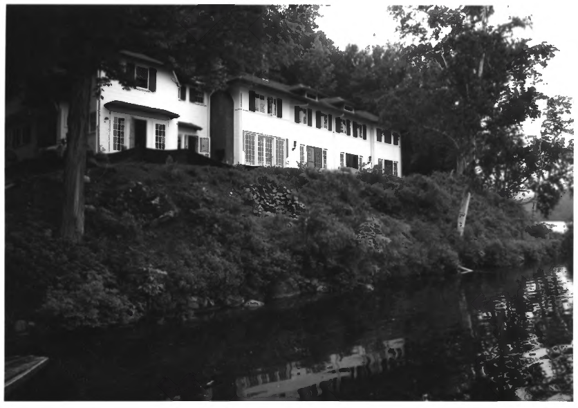
Dreamhome (1996) [click photos to enlarge] Dreamhome is a large, two-story frame summer cottage that is sheathed in shiplap siding and covered by a hip roof. It has a large number of windows and French doors. In addition to the main building, the property features a one-story, hip roofed guest house, a frame boathouse with a cross gabled roof, and landscaped grounds. The sixteen acre property occupies a dramatic site between the shore of Lake Christopher on one side and a steep cliff of Mount Christopher on the other.
It was apparently built about 1916 for William Ellery and his wife Bessie (Collier) Ellery. Landscape architect Harold Hill Blossom developed the plans for the grounds. It was originally the centerpiece of a 125 acre estate that bordered the southwestern half of Lake Christopher, including a small island and several other buildings, including a log cabin and log outhouse. According to local tradition, the name is comes from Bessie Ellery who dreamed of building a house on this site while summering in a nearby cottage.* B&W Kirk F. Mohney photo]
Color Photo: By Magicpiano – Own work, CC BY-SA 3.0, https://commons.wikimedia.org/w/index.php?curid=35316069
Whitman Memorial Library
[1 mile Southwest of junction of Maine Route 26 and Maine Route 232 in Bryant Pond]

Whitman Library (1994)
Completed in the spring of 1910 by local contractor Alton H. Bacon, the Whitman Memorial Library is a modest one-story Colonialrevival style building of frame construction. Funding was provided in the will of Eleanor Bryant Whitman. It is named for her and her husband Alanson M. Whitman. The Library appears to have been the first public library in Woodstock. The Whitmans were descended from two of the earliest settlers of the town: Samuel Bryant and Luther Whitman.
On October 23, 1908, a special town meeting was held to consider the gift and a unanimous vote accepted it. The Whitman Memorial Library is a modest building but it clearly is one, with its design, location, and purpose, has an important place in the community.* [Kirk F. Mohney photo]
Frost has moved the Granite Slabs the South Woodstock Meeting house Sits on. The town don’t want to spend the money to fix the problem and are talking about Tearing The old meeting house down.This is really bad because we will be losing another part of who we are in South Woodstock and in Maine.
A Fundraiser might be able to save the old building. Will some one please save this building?