")

Location Map for Winter Harbor
| Year | Population |
|---|---|
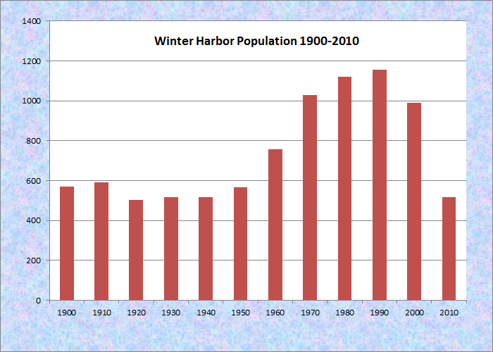
| 1970 | 1,028 |
| 1980 | 1,120 |
| 1990 | 1,157 |
| 2000 | 988 |
| 2010 | 516 |
Population Trend 1900-2010
| Geographic Data | |
|---|---|
| N. Latitude | 44:20:34 |
| W. Longitude | 68:04:13 |
| Maine House | District 136 |
| Maine Senate | District 6 |
| Congress | District 2 |
| Area sq. mi. | (total) 65.7 |
| Area sq. mi. | (land) 14.4 |
| Population/sq.mi. | (land) 35.8 |
County: Hancock
Total=land+water; Land=land only |
|
")
Winter Harbor Historical Society (2004)
")
Winter Harbor
[win-ter HAR-bor] is a town in Hancock County, settled in the early 1800’s and incorporated on February 21, 1895 from a portion of Gouldsboro. The name reflects the fact that the harbor does not freeze in winter.
The southern portion of the town is occupied by a portion of Acadia National Park on Schoodic Point. While several interpretations compete, Eckstorm suggests that the Micmac term eskwodek, meaning “the end,” is a good candidate for Schoodic’s origins in this case. John Godfrey Moore owned the point and opened it to the public in 1897.
")
Egg Rock from Schoodic Pt.
")
Schoodic Point (2004)
The 2004 Comprehensive Plan Update notes some of the town’s historic structures and areas, including an old New England style white clapboard church, the First Baptist Church of Winter Harbor, built in 1878:
")
Hammond Hall (2004)
")
First Baptist Church (2004)
Other old structures are our town office, Hammond Hall, and the present home of our Historical Society (a former school) and Channing Chapel Library. Grindstone Point is an historical area that has been a part of Winter Harbor since the late 1800’s. This section of town was established by wealthy “main-line” Philadelphia families and consists of many fine old summer “cottages”. There is a “tea house” on the western shore that has been preserved, and a lovely old yacht club that celebrated its 100th anniversary in 1990.
The 1904 Hammond Hall, a community center, is an historic building named for Edward J. Hammond. A resident in his youth, he founded Hammond Lumber Company, and donated the land and materials for the hall.
The Winter Harbor Lobster Co-op has about 30 members/ owners. In addition to purchasing and shipping lobsters, the co-op provides local lobstermen with supplies, such as bait, gear, and parts.
Winter Harbor hosts two nature preserves. Schoodic Island is a sixty-one-acre nesting site for bald eagles and sea birds managed by Acadia National Park and The Nature Conservancy.
Turtle Island, almost entirely covered by a 150 year old spruce-fir forest, maintains a colony of great blue herons. The interior is closed during the nesting season. Thickets of raspberries and blackberries compete in open areas with cherries and gray birches. There is a seal haul-out on the southern tip, and extensive tide pools. This too is managed by the nature Conservancy.
")
Winter Harbor and Winter Harbor Light on Mark Island. (2004) It is now privately owned having been discontinued in 1933.
")
Public Library (2004)
According to the Northeast Fisheries Science Center,
The Naval Security Group Activity Winter Harbor began as the Otter Cliffs Radio Station on Aug. 28, 1917 and moved to Winter Harbor in 1935. During World War II, it served as the “most important and most efficient station in the world,” according to Navy documents (Urban 2002). The Naval Station was decommissioned in 2001 and the 100 acre site reverted back to the National Park Service.
The town’s recent population decline is due is large part to the closing of the U.S. Navy base.
Winter Harbor lies south of U.S. Route 1 through Gouldsboro on Route 186.
Form of Government: Town Meeting-Select Board-Manager.
Additional resources
Hahn, Nathalie White. A History of Winter Harbor Maine. 1974.
Harvey, Philippa A. Winter Harbor: Community In Change? 1850-1870. 1985.
*Maine. Historic Preservation Commission. Augusta, Me. Text and photos from National Register of Historic Places: http://pdfhost.focus.nps.gov/docs/nrhp/text/xxxxxxxx.PDF and http://pdfhost.focus.nps.gov/docs/nrhp/photos/xxxxxxxx.PDF
Egg Rock Light Station: https://npgallery.nps.gov/pdfhost/docs/NRHP/Text/87002270.pdf
Hammond, Edward J., Hall: https://npgallery.nps.gov/pdfhost/docs/NRHP/Text/03001405.pdf
Schoodic Historic District: https://npgallery.nps.gov/GetAsset/0644266c-4ef2-4148-986a-a69e8468d96f [much more detail at this site]
U.S. Naval Radio Station buildings: https://www.nps.gov/nr/feature/places/pdfs/13000533.pdf
Winter Harbor Light Station: https://npgallery.nps.gov/pdfhost/docs/NRHP/Text/87002538.pdf
Smallidge, Allan. Musquito Harbor: A Narrative History of Winter Harbor, Maine, 1790-2005. Winter Harbor, Me. Ironbound Press. 2006.
Smallidge, Allan. A Summering Place: Winter Harbor, Maine: The Early Years. 1994.
Town of Winter Harbor. Winter Harbor Comprehensive Plan Update, June 2004. http://www.hcpcme.org/winterharbor/winterharborcompplan092204.htm (accessed May 4, 2012)
NOAA. Northeast Fisheries Science Center. WINTER HARBOR, ME. Community Profile. http://www.nefsc.noaa.gov/read/socialsci/community_profiles/ME/winter%20harbor-me.pdf (accessed May 4, 2012)
National Register of Historic Places – Listings
Egg Rock Light Station
") [Egg Rock, in Frenchman Bay] The 1875 Egg Rock Light Station, on a bold rock island at the entrance to Frenchman Bay, is the only one with this configuration in Maine. It is prominently located in Frenchman Bay between Mount Desert Island to the west and Schoodic Peninsula to the east. Built in response to the rising maritime traffic in the bay, it served increasing traffic associated with summer tourism in and around Bar Harbor. A steam powered fog signal was added in 1904.
[Egg Rock, in Frenchman Bay] The 1875 Egg Rock Light Station, on a bold rock island at the entrance to Frenchman Bay, is the only one with this configuration in Maine. It is prominently located in Frenchman Bay between Mount Desert Island to the west and Schoodic Peninsula to the east. Built in response to the rising maritime traffic in the bay, it served increasing traffic associated with summer tourism in and around Bar Harbor. A steam powered fog signal was added in 1904.
Egg Rock was automated in 1976, and its ancillary buildings, with the exception of the fog signal, were removed. The station’s unique design reflects on-going experimentation with the arrangement of these coastal structures.* [Robert Moore photo]
Hammond, Edward J., Hall
") [Main Street, Winter Harbor] The Edward J. Hammond Hall has hosted both governmental and social functions for the Town of Winter Harbor since its construction in 1903. Built a year after a devastating fire leveled much of the commercial center of town, the Hall reflects the town’s growth as a result of tourism at the end of the 19th century. Architecturally, is a remarkable building both for its material integrity, which has remained intact with very few exceptions, and as one of the only classically inspired public buildings in the town.
[Main Street, Winter Harbor] The Edward J. Hammond Hall has hosted both governmental and social functions for the Town of Winter Harbor since its construction in 1903. Built a year after a devastating fire leveled much of the commercial center of town, the Hall reflects the town’s growth as a result of tourism at the end of the 19th century. Architecturally, is a remarkable building both for its material integrity, which has remained intact with very few exceptions, and as one of the only classically inspired public buildings in the town.
Throughout most of the 19th century the town’s livelihood was based around the marine and lumber resources. This changed in the late 19th century, as Winter Harbor was ‘discovered’ by the rusticators and summer people who had colonized Bar Harbor and Mount Desert Island just across Frenchman’s Bay. A Winter Harbor native, who had moved to Boston, joined with two partners to build The Beacon Hotel in 1887. As the principals of the Winter Harbor Land Company, Edward J. Hammond and his partners subdivided Hammond’s substantial land holdings in town for sale as cottage developments. The course that Hammond envisioned for Winter Harbor resulted in significant changes for the settlement. Both sets of resort construction projects had the effect of strengthening the economy for the residents and merchants of Winter Harbor, and the population of the town was inflated by the crafts, trades and service people associated with the hotels and cottages. In 1896 the Town of Winter Harbor separate from Gouldsboro and was incorporated as a town. The Town did not have a formal Town Hall until 1903.
Between 1903 and 1958 Hammond Hall was home to the Winter Harbor Town Hall, as well as host for movies, plays, vaudeville acts, dances, orchestras, proms, graduations and town meetings. In 1958 the town offices relocated to the old high school, and while the building continued to be used for performances and meetings, its main function was as the gymnasium and basketball court for the school until 1987, when the town sold the building to the Winter Harbor Historical Society. In 2017 the building continued to be home to Schoodic Arts for All, an organization that brings exhibits, music, lectures and theater to the Hall on a regular basis.*
Schoodic Peninsula Historic District
") Schoodic Peninsula is a rocky, wooded headland that juts into the Atlantic at Winter Harbor. Five miles to the west across Frenchman Bay lies Mount Desert Island and the main part of Acadia National Park. Local activities to both protect and provide public access to the scenic peninsula led to its addition to Acadia in 1929. Initial development by the National Park Service in the 1930s, including the construction of a new park road and a naval facility, were begun largely at the behest of John D. Rockefeller, Jr. These and later projects provided public facilities compatible with the natural environment.
Schoodic Peninsula is a rocky, wooded headland that juts into the Atlantic at Winter Harbor. Five miles to the west across Frenchman Bay lies Mount Desert Island and the main part of Acadia National Park. Local activities to both protect and provide public access to the scenic peninsula led to its addition to Acadia in 1929. Initial development by the National Park Service in the 1930s, including the construction of a new park road and a naval facility, were begun largely at the behest of John D. Rockefeller, Jr. These and later projects provided public facilities compatible with the natural environment.
")
")
Schoodic Peninsula Historic District encompasses 1,083 acres, along the shore line and the southeast portion of the peninsula within the 2,125-acre park boundary. Historic resources include the curving route of the perimeter loop roadway system, hiking trails, a Civilian Conservation Corps-era truck trail, garage, restroom and maintenance buildings, and a commemorative plaque.The District covers resources within park boundaries on Schoodic Peninsula and Big Moose Island.
Humans have occupied the peninsula for more than a thousand years. Native Americans occupied it and other places around Frenchman Bay at least seasonally to gather shellfish and other marine resources. Wabanakis visited here for berry picking, clam digging, and gathering sweetgrass. The name Schoodic apparently comes from a phrase that means “place of big fire,” possibly accounting for fires set to enhance the growth of the berry bushes.
By the mid-17th century, French and English settlers also occupied the Frenchman Bay region. The region’s residents—Wabanakis, Acadians and New Englanders—formed alliances and trade relationships that were periodically interrupted by sporadic fighting and warfare. With the signing of the 1763 Treaty of Paris and English dominion over the region, many Native American and Acadian settlers were removed or dispersed. Some families seeking new opportunities migrated north to settle here, making a living through fishing, farming, lumbering, and shipbuilding. The first recorded settlement of what is now park land by non-Native Americans was about 1790. Thomas Frazer, an African American, was living at Frazer Point. Frazer had a large family and ran a salt works on the creek until the early 1800s. By the mid-19th century, approximately fifty people were living at Frazer Point. By the end of the 19th century, the Frenchman Bay area had become a popular vacation destination for the middle and upper classes from Boston, New York, and Philadelphia. Winter Harbor, including most of Schoodic Peninsula, was incorporated as a separate town in 1895 to take advantage of the increased tax base brought about by an influx of summer residents.*
U.S. Naval Radio Station- Apartment Building and Power House
 This complex of structures on Big Moose Island at Schoodic Point in Winter Harbor is recognized primarily for their association with John D. Rockefeller, Jr. and his contribution to Acadia National Park’s physical development. Rockefeller, a nationally prominent philanthropist, was directly involved in many aspects of the park’s development. He was responsible for orchestrating the relocation of the Otter Cliffs Naval Radio Station on Mount Desert Island to land he had donated previously to the park on Schoodic Point. This accommodated the development of the park’s loop motor road on Mount Desert. The effort involved Rockefeller in protracted negotiations between the War Department and Department of the Interior. It shows the unique standing he held as a result of his philanthropy toward the National Park System.
This group of buildings are outstanding examples of the Rustic Norman style and representative works of the nationally prominent, New York based architect Grosvenor Atterbury. They reflect the design aesthetic that Atterbury developed specifically for Acadia National Park at Rockefeller’s request during the development of the park’s Carriage Road System in the 1920s. The application of the Rustic Norman style–exhibited prominently by high, steeply pitched hip roofs; half-timbered gable ends; and elaborate brick and stone work–made the buildings unusual.* [National Park System photo, undated]
Winter Harbor Light Station
[Mark Island, Winter Harbor] Winter Harbor Light Station was established in 1856 on Mark Island as a guide to nearby Winter and Mosquito harbors. It served as a primary navigational aid to the local fishing fleet as well as nearby maritime transportation routes. It became increasingly important in the late 19th century as the development of the summer tourist industry on Mount Desert Island increased the number of pleasure craft in the area.
")
The light was decommissioned in 1934 and sold to a private citizen. The station’s distinctive character contains elements of light station design and construction dating to the 1850s and 1870s.*