
| Year | Population |
|---|---|
| 1970 | 7,299 |
| 1980 | 8,057 |
| 1990 | 7,997 |
| 2000 | 7,743 |
| 2010 | 7,794 |

Population Trend 1790-2010
| Geographic Data | |
|---|---|
| N. Latitude | 44:31:23 |
| W. Longitude | 69:34:45 |
| Maine House | District 78 |
| Maine Senate | District 16 |
| Congress | District 1 |
| Area sq. mi. | (total) 38.7 |
| Area sq. mi. | (land) 36.9 |
| Population/sqmi | (land) 211.2 |
| County: Kennebec
Total=land+water; Land=land only |
|
")
Civil War Memorial at Monument Street (2013)
 [WINZ-low] is a town in Kennebec County, incorporated on April 26, 1771.
Originally a much larger tract, it contributed land on the west side of the Kennebec River for the formation of Waterville in 1802.
It later ceded land to Fairfax (now Albion) in 1810, to Harlem (now China) in 1813, and to form part of China in 1818.
According to Varney,
In 1676, the second year of King Philip’s War in Maine, Abraham Shurte, the magistrate at Pemaquid, held a parley with the Indians near where Fort Halifax was built about 75 years later. He was received by the Indians in the “great wigwam” or fort; but he was unsuccessful in his attempt to end the war. (p. 596.)
")
The Sebasticook River entering the Kennebec River at Winslow (2003)
At the confluence of the Kennebec and Sebasticook rivers, Winslow occupies the site of a former Indian village and was named for General John Winslow who participated in building Fort Halifax in 1754. Captain William Lithgow, first commander of the Fort, built his home here.
")
Replica of Fort Halifax (2003)
The blockhouse, part of the original fort, was built in 1754 and was the oldest in the United States, until destroyed during the great flood of 1987.
")
Detail of Fort Halifax Replica (2003)
Fort Halifax was originally many blockhouses connected with fences. A reconstructed blockhouse, which incorporates many original timbers salvaged from the flood, stands on the fort’s original site.
In 1775, Benedict Arnold’s expedition stopped at the Fort, which had become home to Ephraim Ballard whose wife Martha would arrive two years later. She was a midwife and chronicler of local events.
")
1806 Schoolhouse, Rt 32 (’13)
As did most Maine towns, Winslow sent many men to support the Union forces during the Civil War. The memorial at Monument Street is a replica of many found throughout the state.
")
Hollingsworth & Whitney Co. paper mill (c. 1909)
Winslow is the birthplace of early 20th century U.S.Senator Charles Fletcher Johnson, who was also on the U.S. Circuit Court of Appeals for the first circuit (1917-1929). More recently Winslow has been the site of paper mills and is commercially and culturally part of the Waterville-Winslow area. The H&W mill shut in 1997 with much of its equipment removed.
")
Paper Mill in Winslow (2001)
A restaurant, near the Fort, was one of the local sites filmed in 2003 during the production of the movie Empire Falls, based on the Pulitzer Prize winning novel by Maine author Richard Russo.
Winslow is on the east side of the Kennebec River, across from Waterville, on Routes U.S. 201 and Maine routes 32, 100, 100A, and 137.
Benedict Arnold’s Expedition Route – click a Bateau

 <== To Quebec To Beginning ==>
Form of Government: Council-Manager
Additional Resources
Desjardin, Thomas A. Through A Howling Wilderness: Benedict Arnold’s March to Quebec, 1775. 2006.
“Hollingsworth & Whitney Co. paper mill” photo. Repository: Library of Congress Prints and Photographs Division Washington, D.C. Call Number: PAN US GEOG – Maine no. 20. http://www.loc.gov/pictures/item/2007662226/ (accessed December 13, 2017)
Horne, Hope Braley. Winslow: Our Town, Our People. Winslow, Me. H. B. Horne. 1991. Decorah, Iowa. Anundsen Publishing Co.
Kingsbury, Henry D. Town Of Winslow. New York. H.W. Blake & Co. 1892.
*Maine. Historic Preservation Commission. Augusta, Me. Text and photo from National Register of Historic Places: http://pdfhost.focus.nps.gov/docs/nrhp/text/xxxxxxxx.PDF, http://pdfhost.focus.nps.gov/docs/nrhp/photos/xxxxxxxx.PDF
Brick School: 77000068.PDF
Fort Halifax: 68000015.PDF
Shurtleff, Jonas R., House: 74000173.PDF
Two Cent Bridge: 73000132.PDF
Varney, George J. A Gazetteer of the State of Maine. 1881. p. 595-596.
Waterville-Winslow: Industrial, Educational, Business Center Of Maine. Waterville, Me. Chamber of Commerce. 1948. [University of Maine, Orono, Special Collections]
National Register of Historic Places – Listings
Brick School
[South of Winslow on Cushman Road; Route 32, near Mailbox 22] This humble one-room school house was built sometime between 1800-1820 for use in School District No. 5. The building ceased to be used as a school after 1865 and has apparently been employed only for occasional storage until its acquisition by the Winslow Historical Society in 1972. The Society now maintains the structure in a stabilized condition.
")
")
The The Brick School testifies to early determination to provide public education and its staunch construction indicates a permanency that suggests its builders expressed a continuing commitment to this goal.*
Fort Halifax, National Historic Landmark
[U.S. 201] This structure is the oldest existing wooden blockhouse in the United States. It was erected as part of Fort Halifax in 1754 and is now the only surviving element of that complex. It is an excellent example of its architectural type. Built of hewn logs with dove-tailed and pegged joints, the structure is approximately 20 feet square at the foundation and 2 stories high with an overhanging second story and hipped roof.
Use of Fort Halifax as a military post appears to have ended in 1766. The Fort Halifax Chapter, Daughters of the American Revolution acquired the blockhouse in 1924 and maintained it until 1965 when it was given to the State of Maine. Now operated as a museum.*
Shurtleff, Jonas R., House
")
")
Shurtleff House (2018)
[Augusta Road; N44° 31′ 34.46″ W69° 38′ 30.19″] The Shurtleff House is one of Maine’s finest examples of a carpenter Gothic cottage in a rural area. During the 1840s and 1850s the Gothic cottage was popular as the ideal house for suburban and rural America. While some were architect designed or copied directly from pattern books, many cottages were the work of local carpenter-builders who made their own interpretations of the current style. This is probably the case of the Shurtleff House. The first owner of the house was Jonas Ball Shurtleff. While living in Waterville, Shurtleff purchased a thirteen acre lot in Winslow in 1849. The lot had been the site of the home of the Rev. Joshua Cushman, a Revolutionary War veteran who settled in Winslow in 1784.
")
")
Shurtleff House (2018)
Shurtleff built the Gothic cottage between 1850 and 1853. In 1854 he transferred the property to his wife Mariette and both continued to live there until his death in 1863 and hers in 1903. When completed, the cottage became a landmark of considerable local interest. In an account of Winslow in 1864, a writer noted, regarding the house “. . . we come first to the home of the late Mr. Shurtleff. All travelers know this place on account of the fanciful finish of the house.” In the years since Mr. Jonas B. Shurtleff sold his home, later occupants have carefully preserved its ornamental exterior. Originally brown, it is affectionately known by local residents as the “Gingerbread House”. Later painted red with white trim, Shurtleff’s cottage continued to attract attention.* [Earle G. Shettleworth. Jr., B&W photos, 1974] Note that the adjoining barn has been removed since 1974.
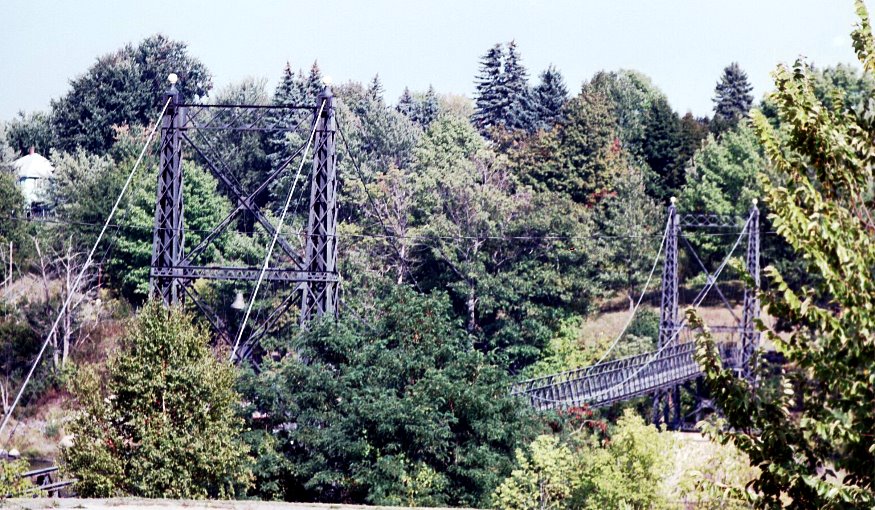
Two Cent Bridge
[spans the Kennebec River at Temple Street, Waterville-Winslow] The bridge is approximately 700 feet long spanning the Kennebec River between Waterville and Winslow, a slight distance above Ticonic Falls. When the bridge was built, its intended use was for the transportation of millworkers between the two communities to the abutting mills. [See more at Waterville.]
Maine Archeological Survey Site 53.36, Address Restricted