
| Year | Population |
|---|---|
| 1970 | 269 |
| 1980 | 335 |
| 1990 | 407 |
| 2000 | 430 |
| 2010 | 487 |
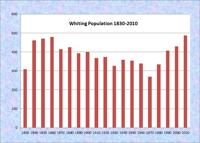
Population Trend 1830-2010
| Geographic Data | |
|---|---|
| N. Latitude | 44:30:48 |
| W. Longitude | 69:26:08 |
| Maine House | District 139 |
| Maine Senate | District 6 |
| Congress | District 2 |
| Area sq. mi. | (total) 52.1 |
| Area sq. mi. | (land) 46.8 |
| Population/sq.mi. | (land) 10.4 |
County: Washington
Total=land+water; Land=land only |
|
")
Welcome to Whiting (2011)
[WHITE-ing] is a town in Washington County, incorporated on February 15, 1825 from Orangetown Plantation. formerly the township 12 ED, BPP.
In 1780, Boston Tea Party activist Colonel John Crane became the first white settler in the area of the town that was to be named for Timothy Whiting, an early land owner and member of the State Legislature.
In the late 19th century, when hay and potatoes provided a major source of income, Whiting was home to two saw mills producing about 475,000 feet of lumber in a year.
The town has had a remarkably stable population since its inception: 1850 – 470; 1900 – 399; 1950 – 354; 2000 – 430. Its low point was 1970’s count of 269 residents.
")
WHITING VILLAGE ON THE ORGAGE RIVER (2004)
Water abounds in Whiting’s the northern half, with many acres of lakes and ponds. The village of Halls Mills is the center piece of the 1126-acre Rocky Lake, the 235-acre Orange Lake and the 120-acre Indian Lake.
Rocky Lake is a shallow, irregularly-shaped body of water located several miles north of Route 1. A public boat launch is near the outlet, but extensive shallows make it difficult to motor up the lake.
In 1811, John Raymond erected a sawmill at what became known as Connecticut Mills. Peter Hall owned the property from 1829 until 1867. The community was renamed Halls Mills in 1907, and members of Hall’s family operated the facility until 1938. The mill was torn down around 1952.
Orange and Indian Lakes are near Route 1. Indian is developed with camps and year-round residences. A boat launch is available on the Route 1 end of the lake.
The town dips its toes in salt water in the west on Holmes Bay in Machias Bay; and in the east with a sliver of shoreline on Whiting Bay near Whiting village.
The main village is located at the easterly end of the township where the Orange River flows into Whiting Bay at the Junction of U.S. Route 1 and Maine Route 189 to Lubec. A dam creates a pond on the river in the village.
Cutler Coast Public Preserved Land, in Cutler and Whiting, contains almost five miles of dramatic cliff-bound ocean shore. The 12,000-acre area represents the eastern tip of Washington County where peatlands, blueberry barrens, partially forested ledges, and thick, swampy woods dominate the countryside.
Unusual features like grasslands and meadows, windswept coastal headlands and steep, jagged cliffs that jut into the ocean hug the 4.5 miles of totally undeveloped coastline. Access is from Route 191 in Cutler.
")
Orange River “lake” North of U.S. Route 1 (2004)
Form of Government: Town Meeting-Select Board-Administrative Assistant.
Additional resources
Forslund, Gladys Hall. History of Whiting, Maine. Calais, Me. Advertiser Publishing Co. 1974.
Halls Mills Lumber Company. “Records, 1855-1975.” (bulk 1929-1940) [University of Maine, Raymond H. Fogler Library, Special Collections]
Maine. Department of Inland Fisheries and Wildlife. “Maine Lake Survey Maps – Washington County.” http://www.maine.gov/IFW/fishing/lakesurvey_maps/washington/index.htm (accessed April 11, 2014)
Varney, George J. A Gazetteer of the State of Maine. 1886. p. 589.
National Register of Historic Places – Listings
Photos, and edited text are from nominations to the National Register of Historic Places researched by Maine. Historic Preservation Commission.
Full text and photos are at https://npgallery.nps.gov/nrhp
Union Meeting House, Whiting, 1836, 1904
The Union Meeting House in Whiting is a rare example of a once-common type of19th-century New England religious architecture. Built in 1836, this symmetrically composed, timber frame building has the proportions, features and composition of a Federal-style meeting house, but also has a prominent Greek-Revival style closed pediment on the façade. Built to serve both the Congregational and Methodist-Episcopal societies, the building is now the only church in this small, rural town.
As the membership in the congregations ebbed and flowed, the church received periodic stylistic updates, including the addition of a belfry and an interior renovation that included tin walls and ceilings and new pews, most likely in the late 19th-century. The Meeting House is a good example of rural church architecture from the second quarter of the 19th-century.The belfry was added and the interior remodeled in 1904.