
Location Map for Westport
| Year | Population |
|---|---|
| 1970 | 228 |
| 1980 | 420 |
| 1990 | 663 |
| 2000 | 745 |
| 2010 | 718 |

Population Trend 1830-2010
| Geographic Data | |
|---|---|
| N. Latitude | 43:54:21 |
| W. Longitude | 69:42:00 |
| Maine House | District 89 |
| Maine Senate | District 13 |
| Congress | District 1 |
| Area sq. mi. | (total) 14.2 |
| Area sq. mi. | (land) 8.7 |
| Population/sq.mi. | (land) 82.5 |
County: Lincoln
Total=land+water; Land=land only |
|
") [WEST-port] is an island town in Lincoln County, incorporated on February 5, 1828 from the western portion of the town of Edgecomb, thus “Westport.”
[WEST-port] is an island town in Lincoln County, incorporated on February 5, 1828 from the western portion of the town of Edgecomb, thus “Westport.”
The narrow ten mile long island, once known as Jeremisquam, was sold by the sagamore Robinhood to John Richards in 1649.
According to the Town’s Comprehensive Plan,
There are early references to settlers in the 1600’s, but due to Indian wars, no permanent settlements were made until about 1735. Most of the early settlers were farmers, and each farm was an independent unit. They raised their own food, produced leather and wool from their cattle and sheep, and cut their own wood. Some earned their living from the sea, and all early transportation was by water.
")
Salt Water Farm (2004)
")
Squam Creek & Back River
The first areas to be settled were the mill sites. There were four early mills, initially used for grinding meal. They later became sawmills, employing many people. All were run by the power of the tides.
")
1794 Town Hall (2003)
")
Town Office (2003)
The fishing business was very important just prior to the Civil War. There were large wharves from which the vessels went out to the Grand Banks for cod and other food fish. Each member of the crew along with the owners claimed a share of the catch, and the profits were divided. There was some boat building, but no large vessels were built on Westport. However, many residents served on ships sailing out of Bath and Wiscasset, including some famous sea captains in the China and other trades.
In the 1880’s the steamboat business was established and Westport had two ports of call – upper and lower landing- or the “Junction,” so called because passengers transferred there to smaller boats. This business was abandoned around the 1920’s with the coming of the automobile and better roads.
")
Westport Shore at Cowseagan Narrows (2004)
Westport is bounded by the Back, Sasanoa, and Sheepscot rivers, deep inlets from the Gulf of Maine. It is accessible by the bridge over the Cowseagan Narrows on Maine Route 144 from U.S. Route 1 in Wiscasset.
")
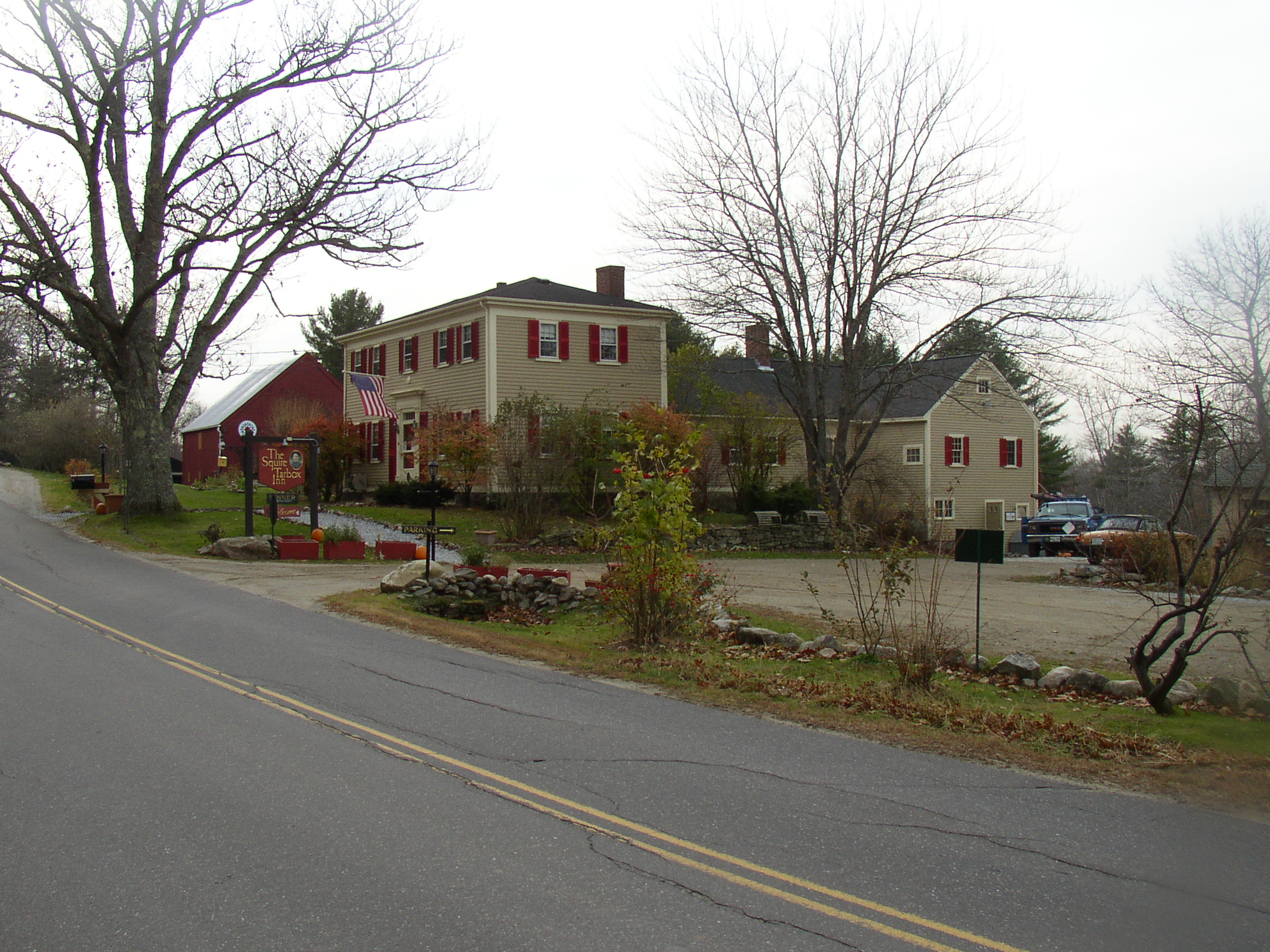
Squire Tarbox Inn (2004)
One of its noted nineteenth century residents, businessman Samuel Tarbox, was influential in the community. His former home is now the Squire Tarbox Inn.
Currently the town is a residential area, with some informal farming and home-based occupations. Westport’s still small population more than tripled in the thirty years from 1970 to 2000 (though it declined slightly in 2010) as the mid-coast area continues its growth spurt.
")
Near Goose Rock Passage (2004)
Form of Government: Town Meeting-Select Board-Administrative Assistant.
Additional resources
Around Wiscasset: Alna, Dresden, Westport Island, Wiscasset, and Woolwich. Dover, N.H. Arcadia Publishing, c1996. [University of Maine, Raymond H. Fogler Library, Special Collections; Maine State Library]
Maine. Historic Preservation Commission. Augusta, Me. Text and photos from National Register of Historic Places.
Town of Westport Island. Comprehensive Plan. 2002. http://www.westportisland.us/cp.html (accessed May 1, 2012)
Westport Island, Maine once Jeremysquam. Compiled by John and Louise Swanton. Westport Island, Me. Published by Westport Community Association. 1993. (Newcastle, Me. Printed by Lincoln County Publishing Company) [University of Maine, Raymond H. Fogler Library, Special Collections; Maine State Library]
National Register of Historic Places – Listings
Parsons, Josiah K., Homestead
 [Greenleaf Cove Road] The Josiah Parsons House (also known as The Lily Farm) is a fine example of the rural Federal style and his Capestyle house trading post is significant as an early commercial building. Captain Parsons, “a Patriot of Bunker Hill”, settled on Westport Island on his return from the Revolutionary War. The York native built his Federal style home in 1792 on what is now Greenleaf Cove. Certainly one of the finest homes on the island, that of Captain Parsons remains almost as it was in 1792. It has fine architectural detailing throughout, including fireplaces, mantels, wainscoting, moldings, corner posts, curving banister, stone hearths, etc. Local people reported that the parlor was so large that they could have “four squares” going when they danced there.
")
Capestyle house trading post (1981)
The “keeping room” still had a removable panel in the north wall, used to take a casket in and out of the house. Parsons became the second largest landholder in Westport and, by 1815, operated the only store or trading post on the island. The Trading Post, built over the water with a boathouse underneath, provided the needs of the island inhabitants. The original counter, cash drawer, and store kerosene lanterns have been well preserved.
")
Lilly Dolphin Pool (1981)
In 1964 scientist John C. Lilly, M.D. purchased the Parsons property and built a concrete pool that he and Mrs. Lilly used in the summer while conducting communication research with dolphins. The Trading Post became a laboratory for recording the human and dolphin sonic output. Man and Dolphin and Mind of the Dolphin, Dr. Lilly’s books, led the Washington Post to call him “one of the most original and fascinating scientists of our time, when original, fascinating scientists are hardly a rarity. He is one of the path breaking explorers of that great terra incognita, the human brain.” Throughout its existence the Parsons Homestead has displayed its adaptive and useful nature and thus has served its inhabitants well.* [Frank A. Beard photos, 1981] The Historic Register erroneously listed this property under Wiscasset.
Union Meeting House (former)
") [Main Road, Maine Route 144] The former 1794 Union Meeting House is a well preserved example of a building type that served both religious and governmental needs in a rural Maine community. The Meeting House was built by the Town of Edgecomb between 1790 and 1794 for use by the residents of Jeremysquam Island (now Westport and previously part of Edgecomb) as the parish church. Southwest of Edgecomb, Westport is a 10 mile long island that at its widest reaches 2 miles east to west. The Back River to the west and the Sheepscot River to the east have fashioned numerous coves and points along the island’s coast, making it very attractive for 18th-century settlers with fishing vessels.
[Main Road, Maine Route 144] The former 1794 Union Meeting House is a well preserved example of a building type that served both religious and governmental needs in a rural Maine community. The Meeting House was built by the Town of Edgecomb between 1790 and 1794 for use by the residents of Jeremysquam Island (now Westport and previously part of Edgecomb) as the parish church. Southwest of Edgecomb, Westport is a 10 mile long island that at its widest reaches 2 miles east to west. The Back River to the west and the Sheepscot River to the east have fashioned numerous coves and points along the island’s coast, making it very attractive for 18th-century settlers with fishing vessels.
Initially all of the island’s civil business was conducted in Edgecomb, but as early as 1774 the island residents were freed from paying taxes to support Edgecomb’s meeting house, since it was generally inaccessible to them. By 1794 a meeting house was raised on the island. Originally occupied by the Freewill Baptists, the Meeting House was not used for town meetings since they were held in Edgecomb until the island was incorporated as the Town of Westport in 1828.
Although one or two town meetings were immediately held in the Meeting House, the residents quickly changed the location to the District #9 school house and reserved the Meeting House for religious worship only. Between 1826 and 1864, the building was shared with a local congregation of Methodists. In 1864 the Methodists purchased the adjoining Music Hall, and relocated the congregation to that building. The Baptists may have disbanded, because for the next 21 years the building sat empty. In 1885 the Proprietors of the Union Meeting House received permission from the Maine Legislature to sell their interest in the building. They promptly transferred it to the inhabitants of Westport for one dollar. Within a few months the town started to remodel the building by adding a stage, (and presumably removing the pulpit and pews), and three years later installing privies.
Although the Meeting House and adjacent Community Church are currently fairly isolated structures on Main Road, in the waning years of the 19th century this was the center of town activity with the Post Office, a store, and the Center School close at hand at the junction of the Post Office Road. The structure was used for many social events, including dances, suppers, and civic association meetings. Between 1912 and 1926 the Westport Grange #516 used the building as their headquarters. In 1917 the selectmen installed a kitchen under the balcony for use by the Grange. The main function of the building, however, has been as the location of Town Meetings. It is here that the community gathers to conduct its annual and monthly business, ironically, just as they had done very briefly, in 1828.*
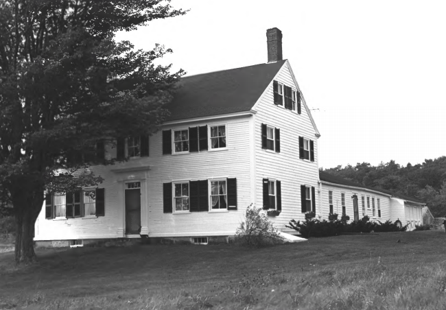
Squire Tarbox House
 [Maine Route 144 Westport] In addition to being a finely preserved Federal house with an exceptional interior and an 18th century ell, the Squire Tarbox House was built for the leading citizen of the community and probably its wealthiest. Tarbox was instrumental in achieving the separation of Westport from Edgecomb as an independent town.
The oldest part of the house was built in 1763 and originally stood on the hill north of its present location. It was purchased from John Parsons by Samuel Tarbox of Litchfield in 1806. In 1819 the Squire, as he was called because of his position in the town, moved the house to its present locating using it as an ell and summer kitchen for the large house he built the following year. In 1950 the house was carefully and correctly restored by its then owner, Eleanor Harriman Smith.
The separation of Westport from Edgecomb was desired because of the journey necessary to attend town meetings since the town hall was in the latter community. In 1828, Tarbox submitted a petition to the Maine State Legislature signed by 73 of the town’s residents, all the male voters, asking that Jeremysquam, as that part of the town was then called become a separate town. The request was granted and a clerk in Augusta wrote in the name, Westport on the town charter for reasons unknown. At the first town meeting, Samuel Tarbox was elected First Selectman.*
Westport Community Church
") [Main Road, Maine Route 144] The Westport Community Church is a striking, small Greek Revival structure that has served many interests in this island community. Built in the 1830s on the property of James McCarty, it was moved to this more prominent location, next to the former Union Meeting House, by 1864. After being positioned on its current foundation, the building was sold to the Methodist Church, who used it for their services until 1950, when it was sold to the Westport Community Association. Currently the building is open seasonally for weddings and meetings.
[Main Road, Maine Route 144] The Westport Community Church is a striking, small Greek Revival structure that has served many interests in this island community. Built in the 1830s on the property of James McCarty, it was moved to this more prominent location, next to the former Union Meeting House, by 1864. After being positioned on its current foundation, the building was sold to the Methodist Church, who used it for their services until 1950, when it was sold to the Westport Community Association. Currently the building is open seasonally for weddings and meetings.
Interior and exterior architectural features suggest a construction date between 1830 and 1840. James McCarty was a sea captain, and the owner of several large vessels. As with most of the population, his home was located on a small inlet, McCarty Cove. The settlement at McCarty Cove supported wharves, a store, and boatyard. Small vessels fished for cod and mackerel from this small harbor. The building was referred to in McCarty’s deed to the Methodist church as a “hail”, and in the family genealogy as a “music hall”, and its location placed on the intersection of the Main Road and the road to McCarty Cove.
It seems unlikely that the structure was tied into McCarty’s fishing venture. It may well have been built on the Main Road as a testimony to his business success and personal cultural refinement. Although many structures on the island were destroyed by a fire in 1918, a windshield survey of remaining 19th-century structures reveals that the Westport Community Church is the most elaborate and refined example of the Greek Revival on the island. The Westport Community Church is a small, but richly elaborated semi-public building that is a very good example of the Greek Revival style in 19th-century coastal Maine.*