Sunset view from Lower Street (2004)
")

Location Map for Turner
| Year | Population |
|---|---|
| 1970 | 2,246 |
| 1980 | 3,539 |
| 1990 | 4,315 |
| 2000 | 4,972 |
| 2010 | 5,734 |
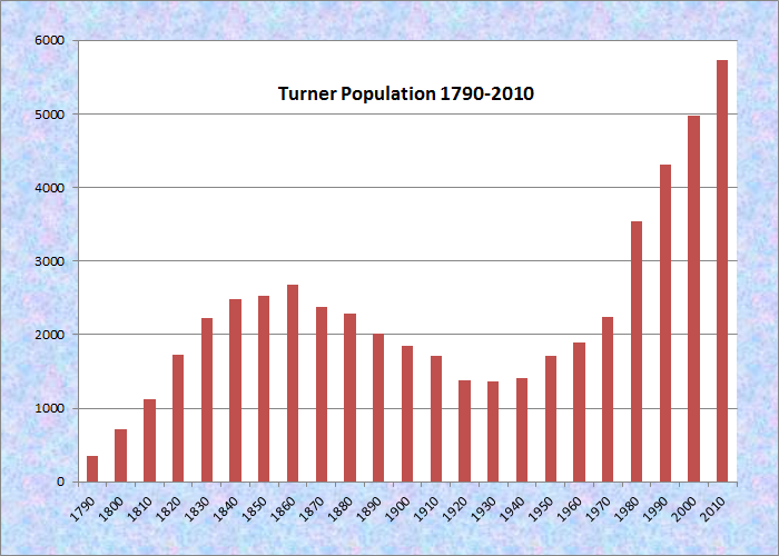
Population Trend 1790-2010
| Geographic Data | |
|---|---|
| N. Latitude | 44:16:00 |
| W. Longitude | 70:14:46 |
| Maine House | District 75 |
| Maine Senate | District 22 |
| Congress | District 2 |
| Area sq. mi. | (total) 62.7 |
| Area sq. mi. | (land) 59.6 |
| Population/sq.mi. | (land) 96.2 |
County: Androscoggin
Total=land+water; Land=land only |
|
")
Town of Turner Seal
[TUR-ner] is a town in Androscoggin County settled in 1690 and incorporated on July 7, 1786 from Sylvester Plantation.
Turner’s history began in 1765, when the Massachusetts General Court chartered and granted some 63 square miles of land in Maine to “the heirs and assigns of Captain John Sylvester and his company, for services rendered in the invasion of Canada under Sir William Phipps in 1690.” Such grants of land to individuals by governments in gratitude for military service was not uncommon in what is now Androscoggin County, some twelve miles north of the modern cities of Auburn and Lewiston.
The town was first named in honor of Captain John Sylvester and his exploits. The new town was called “Sylvester – Canada,” but Sylvester and the other proprietors – as they were called – had considerable difficulty in convincing settlers and their families to move into their grant.
Not until after the Revolutionary War did settlers arrive in appreciable numbers to begin clearing the forests and building homes.
They discovered that the land on which they had settled contained some of the most fertile soil in Maine. In 1786, the town was incorporated and renamed Turner, in honor of the Reverend Charles Turner – one of the original Proprietors, who had worked diligently to promote settlement of the area.
 N44° 16' 16.97\" W70° 13' 28.24\"")
1831 Town House on Route 117 in Turner Center (2013) @
 N44° 16' 14.47\" W70° 13' 37.53\"")
Turner Grange No. 23 on Route 117 in Turner Center (2013) @
 N44° 16' 16.29\" W70° 13' 27.31\"")
First Universalist Church of Turner Center, Rt 117 (2013) @
")
Village Church in South Turner (2003)
 N44° 16' 19.71\" W70° 13' 2.35\"")
Turner Primary School in Turner Center (2013) @
 N44° 16' 17.87\" W70° 13' 9.59\"")
Convenience Store in Turner Center (2013) @
Nearly all of the early settlers were from eastern Massachusetts, and many came from the towns that had sprung up around the original Plymouth Colony. At least one early Turner family, the Bradfords, were Mayflower descendants and traced their lineage from William Bradford, the second Governor of Plymouth Colony.*
Eugene Hale, a 30-year member of Congress beginning in 1881, was born in Turner.
 in Turner (2013) N44° 20' 27.47\" W70° 16' 0.03\"")
Bear Pond from Bear Pond Rd. (Rt 219) (’13) @
 N44° 16' 20.58\" W70° 12' 47.61\"")
Turner Primary School (2013) @
Bounded by the Androscoggin River on the east, Turner has its share of ponds, including Bear Pond and its amusement park. While most of Bear Pond is in Hartford, its outlet, and its Timberlake Memorial Dam, is in North Turner.
The Nezinscot River, a route for canoe trips, passes through the main village on its way to the Androscoggin.
")
Sludge Deposits in the Androscoggin (1973)
The Androscoggin, in the 1970’s, was highly polluted and was the subject of legal and governmental efforts at cleaning it.
")
Old Leavitt Elementary School (2001)
The Leavitt school campus is a community asset linking the old wooden elementary school with the nearby middle school and Leavitt High School with a spectrum of sports fields.
The town has had unwanted notoriety from its DeCoster Egg Farm, which has been cited for many health and labor infractions in the past several decades. The nearby DeCoster Feeds plant is on the rail line in the adjoining town of Leeds.
 N44° 15' 25.08\" W70° 15' 29.18\"")
Turner Town Office on Route 117 (2013) @
Turner lies directly north of Auburn on Maine Route 4, and is served by routes 117 in the south and 219 in the north. South Turner is a smaller village near the Auburn city line.
*This summary is from the Maine State Archives site featuring the Town of Turner at http://www.maine.gov/sos/arc/edu/turner/intro.htm.
Form of Government: Town Meeting-Select Board-Manager.
More Videos!
Additional resources
French, William Riley. A History of Turner, Maine, from its Settlement to 1886. Portland, Me. Hoyt, Fogg & Donham. 1887.
“The Influx of Mexican workers is changing the face of Turner” [sound recording]. Bangor, Me. Maine Public Broadcasting. 1993?
Ploch, Louis A. Turner: A Study in Persistence and Change. Orono, Me. Department of Agricultural and Resource Economics, University of Maine. 1989.
Prince, Rufus. Turner, Maine: Two Centuries of History, Trivia and Observations. Rockport, Me. Penobscot Press, c2000.
Turner in Review. Turner, Me. Town of Turner. 1985. Farmington, Me. Printed by Franklin Printing.
Willard, James H. Turner after 1886. Bowie, Md. Heritage Books. 1986.
National Register of Historic Places – Listings
Photos, and edited text are from nominations to the National Register of Historic Places researched by Maine. Historic Preservation Commission.
Full text and photos are at https://npgallery.nps.gov/nrhp
Turner Cattle Pound
")
")
[southwest corner of Gen. Turner Hill Rd. and Kennebec Trail; N44° 16′ 23.78″ W70° 15′ 8.42″] The first cattle pound keeper in Turner, Moses Stevens, was elected in 1788 one year after the town was incorporated. At that time there is no mention of where the impoundment was to be located or even if Stevens was expected to maintain a dedicated structure.
")
Tree Inside the Pound (2016)
The first mention of a physical impoundment was recorded in 1795, when a vote passed “to build a pound at the meetinghouse” but the location of this pound is unknown, nor was anything more written about it in the Town records. In the same year, Joseph Copeland was elected pound keeper, a role that he continued to fill intermittently for several decades.” The next mention of the pound was recorded during a town meeting held on September 2, 1816. The residents of Turner authorized the building a pound thirty feet square within, to be made of stone six feet high, four feet thick at bottom and eighteen inches at the top, with a good door made of timber with a sufficient lock.
")
Based on this description, the pound was clearly envisioned as a substantial structure to adequately confined wayward beasts. The location chosen for the pound was strategically placed at the intersection of roads running both north-to-south and east-to-west.*
More on Cattle Pounds.
Turner Town House
") [Maine Route 117] The first Turner town meeting was held in 1787 in the church meeting house on Upper Street. From 1822-1830 meetings were held in the local school. In 1830 a meeting was called “to see what measures the town will take to provide themselves with a town house.” It was voted that such should be erected on an isolated little hill about a half mile west of the “center”, the area of earliest settlement. A series of five acrimonious town meetings followed with endless, but fruitless, votes to reconsider the location. The bulk of more recent settlement had taken place along the western edge of the township around a nucleus called the “Village.” Thus, when the question arose over the location of the town house, although the Village was ruled out as not central and convenient, its residents were not willing to give the prestige of the building to the Center and insisted on the exact geographical center of the township as the site. The Center adherents felt that this made no sense and was done out of pure spite. And so on a winter’s night shortly after construction of the town house, men from that part of town gathered, took down the town house (the frame timbers had been pegged and could be taken apart) and re-erected it near the Center burying ground. Weeks later men from the Village took it down again and put it back on its original site. The Center adherents took it down for a third time and put it where it now is, taking the precaution of fixing the timbers with long spikes so they could not easily be taken apart. There the town house remained.
[Maine Route 117] The first Turner town meeting was held in 1787 in the church meeting house on Upper Street. From 1822-1830 meetings were held in the local school. In 1830 a meeting was called “to see what measures the town will take to provide themselves with a town house.” It was voted that such should be erected on an isolated little hill about a half mile west of the “center”, the area of earliest settlement. A series of five acrimonious town meetings followed with endless, but fruitless, votes to reconsider the location. The bulk of more recent settlement had taken place along the western edge of the township around a nucleus called the “Village.” Thus, when the question arose over the location of the town house, although the Village was ruled out as not central and convenient, its residents were not willing to give the prestige of the building to the Center and insisted on the exact geographical center of the township as the site. The Center adherents felt that this made no sense and was done out of pure spite. And so on a winter’s night shortly after construction of the town house, men from that part of town gathered, took down the town house (the frame timbers had been pegged and could be taken apart) and re-erected it near the Center burying ground. Weeks later men from the Village took it down again and put it back on its original site. The Center adherents took it down for a third time and put it where it now is, taking the precaution of fixing the timbers with long spikes so they could not easily be taken apart. There the town house remained.
") Turner Town House is significant as well because of its unusual interior arrangement. From either end of the structure benches in tiers descend to a flat section in the center where the moderator’s platform is located along with a large cast iron stove. Its long use, its strange history and its interesting interior combine to make the Turner Town House a highly significant public building. The only other town house in Maine known to have such an arrangement is the 1840 Town House in Wayne.* [Frank A. Beard 1979 photo]
Turner Town House is significant as well because of its unusual interior arrangement. From either end of the structure benches in tiers descend to a flat section in the center where the moderator’s platform is located along with a large cast iron stove. Its long use, its strange history and its interesting interior combine to make the Turner Town House a highly significant public building. The only other town house in Maine known to have such an arrangement is the 1840 Town House in Wayne.* [Frank A. Beard 1979 photo]
Address Restricted Keens Mills: C. Varney Site, Moyer Site, Quartz Scraper Site, Wood Island Site