
Location Map for Trescott
Trescott was originally known as Plantation No. 9 E. D. (Eastern District of Machias). In 1827 it became incorporated as a town.
By 1945 its declining population led to changing to its current status as an unorganized township. It is located in eastern Washington County between Cutler and Lubec.
According the Gazetteer of Maine in 1886,
Within the town are the harbors of Moose Cove, Bailey’s, Mistake and Haycock. There are here a saw-mill manufacturing long and short lumber, and two grist-mills.
The town is flourishing in trade and navigation. The Trescott Mining and Manufacturing Company is located here.
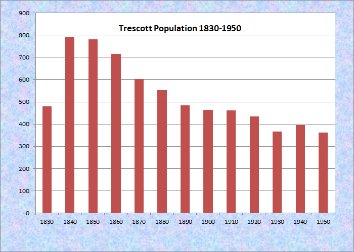
Population Trend 1830-1950
The township has several coastal harbors, one at the village of South Trescott. During the clipper ship boom of the 1850’s, the vessel Sea Lark was launched in 1852.
Served by Maine routes 189 and 191, it has substantial frontage on Cobscook Bay at its northern tip. The 263-acre state-owned Eastern Head, on the coast, was an undeveloped area with potential for becoming a state park.
Additional resources
The Trescott Historical Society. http://www.trescotthistoricalsociety.org/History-of-Trescott.asp (accessed November 25, 2012)
Varney, George J. A Gazetteer of the State of Maine. 1886. p. 543-544.