")

Location Map for Trenton
| Year | Population |
|---|---|
| 1970 | 392 |
| 1980 | 718 |
| 1990 | 1,060 |
| 2000 | 1,370 |
| 2010 | 1,481 |
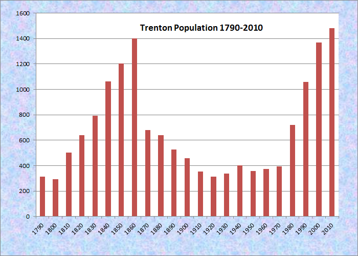
Population Trend 1790-2010
| Geographic Data | |
|---|---|
| N. Latitude | 44:30:48 |
| W. Longitude | 69:26:08 |
| Maine House | District 132 |
| Maine Senate | District 7 |
| Congress | District 2 |
| Area sq. mi. | (total) 39.5 |
| Area sq. mi. | (land) 38.9 |
| Population/sq.mi. | (land) 52.5 |
County: Hancock
Total=land+water; Land=land only |
|
 N44° 25' 40.07\" W68° 21' 59.13\"")
Union River Bay from Bayside Road at Low Tide
[TREN-tun] is a town in Hancock County, incorporated on February 16, 1789 from Plantation Number One East of the Union River. It ceded land to Ellsworth (1809), Hancock (1828) and Lamoine (1870), and annexed land from Eden (1849).
“In 1762 or 1763 a settlement was organized by Ebenezer Thorndike. The area was variously called Thornbury and Thorndike Plantation until its incorporation. Until 1870 Trenton also included the eastern half of the peninsula below the town of Hancock, but in that year it was divided when the town of Lamoine was separately incorporated.”1
 N44° 26' 14.92\" W68° 22' 29.89\"")
Town Office/Fire Dept.(’13) @
 N44° 27' 15.54\" W68° 22' 5.56\"")
Elementary School (2013) @
Trenton was named for the Battle of Trenton (New Jersey) in the American Revolution.
N44° 26' 23.76\" W68° 22' 13.13\"")
Trenton Grange (2013) @
 N44° 27' 6.50\" W68° 22' 1.45\"")
Trenton Baptist (2013) @
According to its Comprehensive Plan,
As in many other coastal towns, lumbering, farming, and fishing were the primary occupations for Trenton residents in the past. Timber was cut from the abundant forests and sawmills built to turn the logs into lumber.
Fishing provided food for the early settlers. Farming consisted of growing grain and vegetables for their own use. A general store was built, where settlers could trade their fish and farm products for household goods. The owner built a windmill for grinding the settlers’ corn into meal.
In the late 1800’s Trenton residents became involved in the coastal carrying trade, granite and ice, to Boston and New York markets and returning with supplies.
Many were sea captains and sailors on the large coasting vessels. Others owned two-masted schooners, which carried lumber, granite, bricks, and other building materials to Mount Desert Island when summer estates were being built there in the late 1800’s.
Lumber was Trenton’s major product during the years of the coasting trade. Many residents were employed in woodcutting or at the large lumber mill located at the “Millcove” at Bayside, from the late 1800’s until 1924.
 N44° 26' 11.37\" W68° 23' 48.15\"")
Union River Bay from Bayside Road (2013) @
")
Union River Bay from Bayside Road (2013)
The Union River was the site of considerable shipbuilding activity. Over 60 vessels were built at Trenton between 1830 and 1860.
Farming has continued to be a subsistence activity, as it was during the early settlement years. Poultry, beef and dairy farming has existed on a small scale along both the Jordan and Union Rivers.
Fishing, which did not play a major role in Trenton’s development, was generally considered a secondary occupation to many residents. Weirs were built along the coast, with the fish sold locally.
Prior to the construction of the Trenton Bridge across the Mount Desert Narrows, a ferry was operated by the Thompson family, who owned Thompson’s Island and the land at the Narrows.
 N44° 25' 1.03\" N44° 25' 1.03\"")
Signs in Western Trenton (2013) @
As in many coastal communities in the 21st century, Trenton is a tale of two communities. Driving south on Route 230 (Bayside Road) from Ellsworth, on the west shore of town, one notes the very modest houses on the inland side and the more substantial houses and cottages set back from the road on the Union Bay side.
There is little public access to the bay with public roads often terminating at private roads discouraging visitors.
")
Thompson Island Park (2003)
Just south of Ellsworth, Trenton’s long shore on the Union River Bay is unusually smooth compared to the indented coastlines of towns to the east. Trenton hosts a visitors’ center and a park on Thompson Island between the mainland and Mount Desert Island.
Route 3, the “Bar Harbor Road,” on the east side has a completely different character, featuring attractions for tourists bound for Acadia National Park.
The Hancock County – Bar Harbor Airport is on Route 3 just north of Bar Harbor. Two airlines that provide New England and beyond travel service were, in 2019, Cape Air and PenAir. Both connect with Boston to continue to other destinations and airlines. Charter flights and general aviation also use the facility.
")
Hancock County Bar Harbor Airport (2013)
")
Hancock County Bar Harbor Airport Terminal
 N44° 26' 8.88\" W68° 22' 8.19\"")
An Information Center on Route 3 (2013) @
 N44° 26' 8.91\" W68° 22' 8.05\"")
Seafood Restaurants Abound (2013) @
Form of Government: Town Meeting-Select Board-Administrative Assistant.
Additional resources
Dodge, Ernest Stanley. Morning was Starlight: My Maine Boyhood. Chester, Ct. The Globe Pequot Press. c1980.
Freeman, William. Ancient Trenton. Ellsworth, Me. Ellsworth American. 1892-1894. [Maine State Library]
1Trenton, Maine. Comprehensive Plan. 2006. http://www.hcpcme.org/trenton/Trenton%20CP.pdf (accessed April 12, 2012)