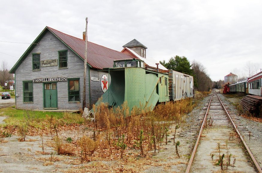
 Farwell Brothers Antiques building near an old railroad line. (2006)

Location Map for Thorndike
| Year | Population |
|---|---|
| 1970 | 439 |
| 1980 | 603 |
| 1990 | 702 |
| 2000 | 712 |
| 2010 | 890 |
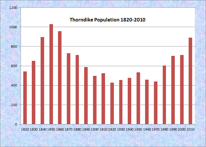
Population Trend 1820-2010
| Geographic Data | |
|---|---|
| N. Latitude | 44:35:46 |
| W. Longitude | 69:14:03 |
| Maine House | District 99 |
| Maine Senate | District 11 |
| Congress | District 2 |
| Area sq. mi. | (total) 25.3 |
| Area sq. mi. | (land) 25.3 |
| Population/sq.mi. | (land) 35.2 |
| County: Waldo
Total=land+water; Land=land only |
|
")
Rail Cars on a Siding (2006)
Mt. View Schools (2006)
")
Thorndike Town Office (2006)
[THORN-dike] is a town in Waldo County, incorporated on February 15, 1819 from Lincoln Plantation. It ceded land to the town of Knox in 1831. The current Town Office is at right.
")
Thorndike Auto Parts(2006)
Settled in 1772, the town lies southeast of Unity on Maine Route 139. It was named for Israel Thorndike, a Federalist State Senator in Massachusetts who was a principal purchaser of Henry Knox’s Waldo Patent in 1806. The “patent” essentially was a deed to ownership of much of the land in Waldo County.
")
Houses in the Main Village (2006)
 [George French photo]")
Haying in Thorndike (1950)
Thorndike is the birthplace of Alden Joseph Blethen (1845-1915) who was raised in Waldo County and rose to become a media baron in the early years of the 20th century.
")
Harvest Moon Grange (2006)
")
Rolling Hills, Thorndike (2006)
While once a farming community, as most Maine towns, Thorndike counted the railroad as a major element in its economy. The remains of that era are obvious in the village. The Belfast and Moosehead Lake Railroad was the latest to use the line.
")
Remains of the Railroad (2006)
")
Remains of the Railroad (2006)
The town hosts Mt. View Schools, the High School and Junior High School serving surrounding communities through Maine School Administrative District 3.
In recent years Amish families have moved to Thorndike, as well as nearby Unity and to Aroostook County, sustaining the remaining agricultural tradition.
Form of Government: Town Meeting-Select Board.
Additional resources
Source: photo “Haying in Thorndike (1950)” courtesy of Maine State Archives, George French Collection.
A Brief History of the Town of Thorndike, Maine, 1819-1919. Thorndike, ME. Newell White. c1919.
Sesqui-centennial Celebration, Town of Thorndike, County of Waldo, State of Maine, August 9, 10, 1969. Maine. 1969.
Taylor, Alan. Liberty Men and the Great Proprietors: The Revolutionary Settlement of the Maine Frontier, 1760-1820. Chapel Hill, NC. University of North Carolina Press. 1990.
Thorndike Centennial Anniversary, 1819-1919, at Thorndike Station, Wednesday, August 6, 1919: programme. 1919. Special Collections, Fogler Library, University of Maine. Orono.
Vital records of Thorndike, Maine prior to 1892. Transcribed by Elizabeth M. Mosher. Camden, Maine, Picton Press, 1993.
National Register of Historic Places – Listings
Photos, and edited text are from nominations to the National Register of Historic Places researched by Maine. Historic Preservation Commission.
Full text and photos are at https://npgallery.nps.gov/nrhp
The Farwell Brothers Store
The Farwell Brothers Store is a functionally related group of three commercial buildings located along the Belfast and Moosehead Lake Railroad line in the Town of Thorndike. The store was built around 1872 and served the community from then until 1960 as a general store with the mill building added about 1915 and the lumber shed added about 1920. The store was owned by O. J. Farwell, and later his sons, from 1875 until 1960. The complex sold groceries, general merchandise, farm implements and feed. The business purchased and traded farm products from local farmers as well.
The buildings are important architecturally for their type, period and method of construction. Individually the store and the mill each represent a once common building type designed and built for a specific purpose. Collectively the complex functioned as a commercial hub for the town. It was a longstanding community anchor in both retail sales and trade or barter of a wide range of agricultural products. The mill is important for its manufacture of ground grain and animal feeds, in the period from from the construction date of the store, about 1872, to its closure in 1960.