 off the Jack Mountain Road in T10 R9 WELS N46° 32' 19.03\" W68° 52' 46.97\"")
Chase Brook Road (left) off Jack Mountain Road (2015) @
This township in Piscataquis County and managed by North Maine Woods, lies just west of T10 R8 WELS where Jack Mountain Road continues, but becomes an unimproved dirt road and ends, at least by that name. An improved dirt road, Chase Brook Road, branches south from Jack Mountain Road, still improved, at Bartlett Mountain.
Water Bodies
Bartlett Pond
Bartlett Pond is an extremely shallow pond of 77 acres with its shoreline surrounded by heath bog. The bottom is heavily silted. The northeast inlet contains fair spawning areas and good to excellent nursery areas for trout. Bartlett Brook, another major inlet, provides excellent spawning and nursery areas. The outlet also provides very good spawning and nursery area for trout.
")
Heavy Equipment in Support of Logging on Jack Mountain Road near Bartlett Pond Road (2015)
There are times when these waters are made impassible to trout by beaver dams thus limiting their productivity. Large populations of yellow perch compete with brook trout for food and space. A short paddle up the outlet is required to reach the pond. Access is via private gravel roads built and maintained by large landowners for forest management purposes. Travelers should be aware of timber harvesting equipment, such as that a right, likely to be moving quickly along roads with limited visibility.
Leonard Pond
This smaller (37 acre) and shallower (three feet) pond is accessible from Jack Mountain Road by an unimproved road. Surrounded by a heath bog and having a muddy bottom severely limits fishing opportunities.
Mooseleuk Lake
The 422-acre Mooseleuk Lake is shallow lake (maximum depth 6 feet) with equal water temperatures at all depths. Water levels in are maintained by a concrete dam built in 1990. The dam and associated wetland habitat was developed cooperatively by Inland Fisheries and Wildlife, Seven Islands Land Company, and Ducks Unlimited.
It was built to stabilize water levels on the lake’s wetlands. Uncontrolled, water levels in the wetlands dropped to undesirable levels during drier summer months. Controlled, these water levels benefit a variety of wildlife, particularly waterfowl. During periods of hot weather, trout seek one of many cool inlets to survive. Populations of yellow perch, suckers and minnows are serious competitors with trout for available food and space. Spawning and nursery areas for trout in the lake tributaries are excellent. The dam is equipped with a fishway and trout move freely between the lake and outlet stream.
Streams
Big Hudson Brook, Blind Brook, Bartlett Brook, Chase Brook and Spring Brook all flow into the wetland around Mooseleuk Lake.
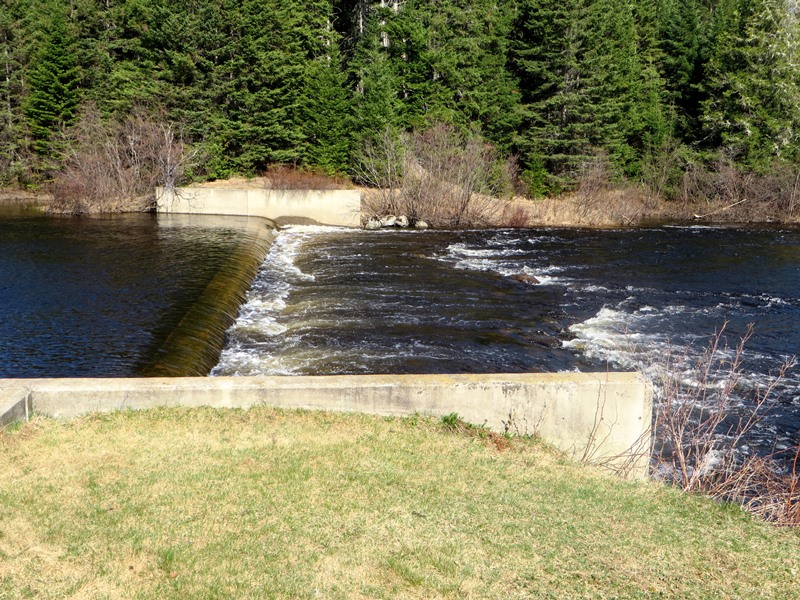
Dam at the Mooseleuk Stream campsite in T10 R9 (2015)
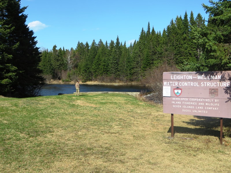
sign: “Leighton Wellman Water Control Structure . . . .” (2015)
Mooseleuk Stream is regulated by a low dam (the Leighton-Wellman Water Structure) in the Township. The stream flows about eleven miles southeast from the dam to the Aroostook River in T8 R8 WELS. It is a prime route for canoe trips in the spring.
The Roads
Should you venture onto unimproved dirt roads, be prepared for an interesting time. These roads have a habit of narrowing and/or softening after a short foray into them. Mooseleuk Stream apparently lies some where down the first “unnamed improved road” in the video. Removing fallen trees, the likelihood of washouts, combined with a scouting report of no stream nearby, discouraged further exploration. Another route in the area, listed as “unimproved” on a map turned out to be an overgrown path at best, impossible to drive.
")
Two Moose Jaws on tree on the Dam Road (2015)
Island Pond Road in adjacent T10 R10 WELS provides a well-maintained route to Mooseleuk Lake, Dam and Campsite. Mooseleuk Mountain is visible on the way. An unnamed road south of Island Pond Road leads one to Little Hudson Brook, which makes its way northeast to Mooseleuk Lake.
Campsites
Mooseleuk Dam Road splits south from the Island Pond Road leading to the campsite and dam at the outlet of the lake, the origin of Mooseleuk Stream. The campsite features three individual campsites, two picnic shelters, three fireplaces, three picnic tables. Camper trailers are not permitted.
Chase Brook Road campsite has two sets of individual campsites, each with a fireplace and picnic table. One privy serves both. Camper trailers are permitted at these sires near a small stream.
These sites are authorized by North Maine Woods, which manages properties in the township.
Surrounding Townships:
T11 R10 WELS T11 R09 WELS T11 R08 WELS
T10 R10 WELS T10 R09 WELS T10 R08 WELS
T09 R10 WELS T09 R09 WELS T09 R08 WELS
More Videos!
Additional resources
“Bartlett Pond, T10 R9, Piscataquis County.” Revised 1998. Maine Department of Inland Fisheries and Wildlife. Funded in part by Federal Aid in Fish Restoration Act under Federal Project F-28-P L1986G. http://www.state.me.us/ifw/fishing/lakesurvey_maps/aroostook/center_pond.pdf (accessed June 25, 2015)
“Leonard Pond, T10 R9, Piscataquis County.” Surveyed August, 1965.. Maine Department of Inland Fisheries and Wildlife. http://www.state.me.us/ifw/fishing/lakesurvey_maps/aroostook/center_pond.pdf (accessed June 30, 2015)
“Mooseleuk Lake, T10 R9, Piscataquis County. Revised 1998. Maine Department of Inland Fisheries and Wildlife. http://www.maine.gov/ifw/fishing/lakesurvey_maps/regiong/mooseleuk_lake.pdf (accessed June 27, 2015)