The township is completely within a tract of Maine Public Reserve Land and lies immediately south of Rainbow Township, host to the next northerly section of the Appalachian Trail. Traveling south, hikers encounter Nesuntabunt Mountain and Nahmakanta Lake that reaches back into Rainbow Township.
According to a 1960 survey,
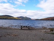
Nahmakanta (Abenaki for “plenty of fish”) is a large, deep, cold water lake. Much of the shoreline is strewn with large granite boulders and there are several beaches of clean, sharp, granite gravel. The surrounding mountains, uncut forests, and unspoiled lake make this one of the beauty spots of Maine. A sporting camp is located on one of the largest sand beaches at the northwest end of the lake.
Nahmakanta Lake Camps have served sportsmen since 1870. While privately owned, the camps sit on land owned by the State of Maine and which surrounds the lake.
Nahmakanta Lake from the Appalachian Trail
The AT (red dots on the map) travels basically east-west south of the lake and Nahmakanta Stream. The lake shore has several camps and cabins serving those who wish to engage in fishing , boating, or observing the local wildlife.
About a dozen smaller ponds and most of Fourth Debsconeag Lake dot the landscape. The township is accessible by improved road from Maine Route 11 in T4 R9 NWP, then to the Jo-Mary Road, which begins near Upper Jo-Mary Lake in TA R10 southeast of T1 R11.
Photos and slide show images courtesy of Brady G. Williams, 2007
More Videos!
Additional resources
Arlen, Alice. In the Maine Woods.
Maine. Bureau of Parks and Lands. Nahmakanta. Maine Bureau of Parks and Lands, Department of Conservation. Augusta, Me. Maine Bureau of Parks and Lands. [199-?]. NOTE: 1 map : col.; 26 x 33 cm. on sheet 28 x 43 cm., folded to 11 x 10 cm. Relief shown by contour lines. Text titled “About Nahmakanta,” “Enjoy your public lands,” and “Leave no trace,” illustrated, and col. maps on verso. (University of Maine, Raymond H. Fogler Library, Orono Special Collections.)


