 N44° 12' 44.49\" W70° 59' 53.58\"")
Cold River in Stow (2014) @

Location Map for Stow
| Year | Population |
|---|---|
| 1970 | 109 |
| 1980 | 186 |
| 1990 | 283 |
| 2000 | 288 |
| 2010 | 385 |
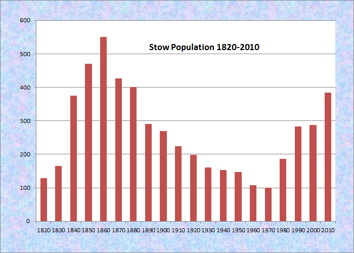
Population Trend 1820-2010
| Geographic Data | |
|---|---|
| N. Latitude | 44:11:54 |
| W. Longitude | 70:58:32 |
| Maine House | District 117 |
| Maine Senate | District 18 |
| Congress | District 2 |
| Area sq. mi. | (total) 24.5 |
| Area sq. mi. | (land) 24.4 |
| Population/sq.mi. | (land) 42.8 |
County: Oxford
Total=land+water; Land=land only |
|
 N44° 15' 57.15\" W71° 0' 33.54\"") [STO] a town in Oxford County, settled in 1770 and incorporated on January 28, 1833 from a tract including Bradley and Eastman’s Grants and Fryeburg Addition.
[STO] a town in Oxford County, settled in 1770 and incorporated on January 28, 1833 from a tract including Bradley and Eastman’s Grants and Fryeburg Addition.
The population in 2010 was similar to that in 1880 when it was recorded at 401. In the 1880’s Stow’s economy included some sawmills, a grist mill, a carriage factory and a blacksmith’s shop.
 N44° 16' 1.99\" W71° 0' 13.29\"")
Bickford Brook Trail (2013) @
Stow borders New Hampshire, which may be reached by Maine Route 113 north from Fryeburg. It was once the home of the Pequawket Indians, who traveled the Pequawket Trail south through Standish to Biddeford Pool during the summers to fish and gather shellfish.
William C. Walker was the son of John and Nancy Cox Walker who settled in Stow shortly after 1800. He appears to have been a shoemaker and perhaps also had a general store or a tavern. His records are at the University of Maine Library in Orono.
The Brickett Place, Historic Site is on Route 113 in the National Forest in Stow. Access to the Bickford Brook Trail, and several others, is on the grounds of the Site.
 N44° 16' 1.62\" W71° 0' 14.10\"")
Brickett Place (2013) @
")
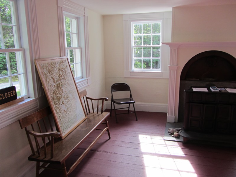
Brickett Place interior (2013)
Bickford Slides are in the extreme north of the town in the White Mountains National Forest. It is a double waterfall, upper and lower, accessible through a National Forest trail.
The Cold River, in the National Forest, enters the state in Stow and flows south through most of this narrow north-south shaped town. The Civilian Conservation Corps had a camp at Cold River in the 1930’s.
A canoe trip requires high water, given the shallows and trees lying across the winding Cold River. Even at high water in April of 2014, several short portages around blocked areas were necessary. The launch site is just below the Deer Hill Road Bridge.
 N44° 13' 32.30\" W71° 0' 20.43\"")
The Deer Hill Road Bridge (2014) @
")
Deer Hill Launch site (2014)
Access to Kezar Lake is available from the town by a small amount of frontage at the Lower Bay portion of that Lake. The old town hall is just a few hundred yards from the new town office.
 N44° 10' 15.61\" W70° 59' 7.93\"")
1842 Stow Town Hall (2014) @
 N44° 10' 5.06\" W70° 59' 2.31\"")
Stow Town Office (2014) @
 N44° 9' 19.52\" W70° 59' 8.15\"")
Stow Corner Store (2014) @
Form of Government: Town Meeting-Select Board.
Additional resources
Barnes, Mary Ellen W. After the Harvest: families, community, and the environment of the Cold River Valley, 1880-1930. Thesis (M.A.) in History–University of Maine, 2000.
Walker, William C. Records, 1829-1843. [University of Maine, Raymond H. Fogler Library, Special Collections]
Varney, George J. A Gazetteer of the State of Maine. 1886. pp. 529-530.
National Register of Historic Places – Listings
Brickett Place
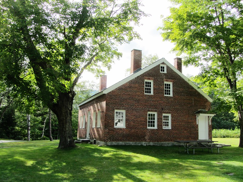 [US Route 113] John Brickett, one of the original settlers in the area that later became Bachelder’s Grant and is now part of Stow, built a substantial and highly individual Federalstyle house on a hill farm in a remote area.. The structure has endured since 1816 in the harsh climate and is still structurally sound. It is the only example of an early 19th century house located on public land in the Cold River Valley.
The house was built by the farmer on land that he did not own. John Brickett and his family arrived about 1803, selected a spot, built a log cabin and cleared land for crops. In 1812 he began construction of the house. He built it of hand hewn timbers and his own handmade bricks. It took four years to complete. In 1816 Josiah Bachelder secured a patent to some 28,000 acres from the State of Massachusetts, including the land where the house stands. John Brickett purchased a 50-acre parcel surrounding his house in 1820 for $100 and the following year purchased an additional 50 acres to the north from the Bachelder estate.
 John and his family lived on the farm until his death in 1863. He willed the house and all of his land to his son, Gardner, who sold it in 1877. It was then sold six times before the Forest Service acquired it in 1918. Since then it has been used by a number of organizations including the Civilian Conservation Corps, Appalachian Mountain Club and Boy Scouts of America. It also served as a Forest Service Guard Station. Through all the transactions, this local landmark has retained its identity as “The Brickett Place.” When John died, he ordered that the executor raise a suitable monument that reflected the stature and station he had in life. The monument that was erected in the small country cemetery is little noticed, but the house that he built stands as a landmark, an enduring testimony to not only his stature and station, but also his skill and craftsmanship.* [See more photos above.]
Source: United States. Department of the Interior. National Park Service. https://npgallery.nps.gov/pdfhost/docs/nrhp/text/07000411.PDF (accessed March 9, 2017)
Nellie B Walker 1872-1973
Have a primitive painting by her documented as Blacksmith Shop, Stow Maine
Seeking any info on the person or site