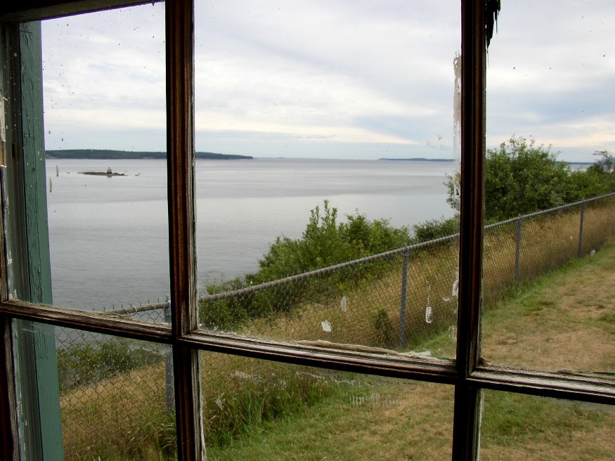
Penobscot Bay from the small museum at Fort Point (2007)

Location Map for Stockton Springs
| Year | Population |
|---|---|
| 1970 | 1,142 |
| 1980 | 1,230 |
| 1990 | 1,383 |
| 2000 | 1,481 |
| 2010 | 1,591 |
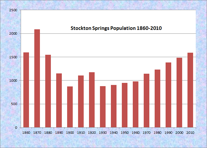
Population Trend 1860-2010
| Geographic Data | |
|---|---|
| N. Latitude | 44:29:25 |
| W. Longitude | 68:50:30 |
| Maine House | District 131 |
| Maine Senate | District 11 |
| Congress | District 2 |
| Area sq. mi. | (total) 29.9 |
| Area sq. mi. | (land) 19.6 |
| Population/sq.mi. | (land) 81.2 |
County: Waldo
Total=land+water; Land=land only |
|
")
Stockton Springs Community Church (2002)
") [STOK-tun SPRINGS] is a town in Waldo County, incorporated on March 13, 1857 as Stockton from a portion of Prospect.
[STOK-tun SPRINGS] is a town in Waldo County, incorporated on March 13, 1857 as Stockton from a portion of Prospect.
Originally named for an English seaport, the name was changed to Stockton Springs on February 5, 1889 in hopes of capitalizing on the bottling of local spring water. However, when sediment was discovered in the bottles, the plan was shelved.
The town lies at the junction of U.S. Routes 1 (east to Bucksport) and 1A (north to Bangor).
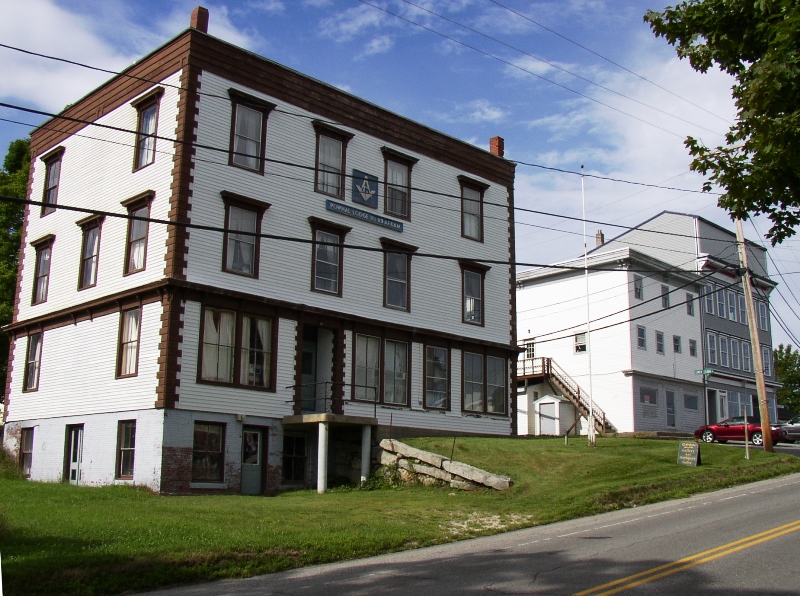
Pownall Lodge of the Masons in Stockton Springs (2007)
")
Stockton Springs Municipal Building (2007)
Fort Point is a peninsular, on Cape Jellison just north of Sears Island, that extends almost to the center of Penobscot Bay at its northerly reaches.
Fort Point State Park features Fort Pownall that British Governor Pownall built there in 1759. The British burned their fort in 1775 and 1779 to prevent it from falling into enemy (American patriot) hands.
A more modern recognition of American patriots in the Veterans Memorial Park in downtown Stockton Springs.
")
World War II Memorial (2007)
")
Korea Vietnam Memorial
Fort Point Light, established in 1836 and still in operation, is well documented at its site at the end of the point.
In the 1880’s, Stockton Springs hosted several factories producing shoes; cheese; doors, sashes, and blinds; lime casks and fish barrels; and clothing.
The Fort Point House was a large hotel and major attraction on the shore of Penobscot Bay from 1872 to 1888.
Fort Point State Park marks the southern end of Fort Point Cove.
Sandy Point Beach is at the northern reach of the cove, with about three-quarters of a mile of shoreline on Penobscot Bay.
The beach is accessible from two roads off U.S. Route 1, one leading to Sandy Point Park in the south [N44° 30′ 24.2″ W68° 48′ 26.9″], and one to a small area at the north end of the beach [N44° 30′ 50.0″ W68° 48′ 35.7″].
 N44° 30' 24.18\" W68° 48' 26.88\"")
Sandy Pt. Park/Beach (2012)
")
Bench on the Beach (2012)
 N44° 30' 25.02\" W68° 48' 25.20\"")
Sand & Old Pilings (2012) @
 N44° 30' 50.41\" W68° 48' 35.69\"")
North End of the Beach (2012) @
")
North End of Penobscot Bay (2012)
Form of Government: Town Meeting-Select Board-Manager.
Additional resources
Ellis, Alice V. The Story of Stockton Springs, Maine. Stockton Springs: Historical Committee of Stockton Springs. 1955.
*Maine. Historic Preservation Commission. Augusta, Me. Text and photos from National Register of Historic Places: http://pdfhost.focus.nps.gov/docs/nrhp/text/xxxxxxxx.PDF and http://pdfhost.focus.nps.gov/docs/nrhp/photos/xxxxxxxx.PDF
Shaw, Richard R. The Lower Penobscot River Region. Dover, N.H. Arcadia. 1996.
National Register of Historic Places – Listings
Fort Point Light Station
[Fort Point Road] Fort Point Light was built at a time of rapidly increasing maritime shipping on the Penobscot River. Bucksport upriver from the Station was a center of local commerce, lumber production and shipbuilding. Bangor, further upriver was in the midst of its lumber fueled economic boom. For decades commercial traffic passed down the Penobscot near Fort Point Light. The station’s distinctive character principally embodies mid-19th century light station design and construction.* See images of the Light Station.
Fort Pownall Memorial
[southeast of Stockton Springs on Fort Point] ln 1755 the Indian menace in Maine was at its peak. Gov. Shirley declared war with the Anasagunticook Indians and all others east of the Piscataqua River except the Penobscots. Governor Thomas Pownall took office in 1757 and proposed that a fort be erected here.* [see photos and more]
Hichborn, Nathan G., House
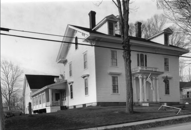 [Church Street] The c. 1850 Hichborn house is an architectural masterpiece in a community of relatively modest homes. Nathan Hichborn was one of Stockton’s leading citizens in the third quarter of the 19th century. Nathan Griffin Hichborn was born in Prospect in 1818. His business career began about 1844 when he established a general store on the Belfast to Bucksport Road. Three years later, Hichborn launched a ship building career that lasted 28 years. Between 1846 and 1874, his shipyard completed forty-two vessels, making him the most prolific builder in Stockton. Beginning with the California in 1846, the N. G. Hichborn yard built thirteen brigs, thirteen schooners, thirteen barks, and three ships. One of which, the Jacob Badger, was the largest vessel built in the community.
 Hichborn’s business, and that of his fellow Stockton ship builders, illustrates the important role which this industry played in the economic development of many Maine coastal towns in the mid-nineteenth century. Hichborn also occupied a prominent role in community. During the early 1850s he was the promoted the construction of the Stockton Springs Community Church (see below), and in 1855 he was appointed to the position of postmaster at South Prospect.
In 1855 Hichborn was also elected to the Maine Senate. The following year he spearheaded a movement to create Stockton from a part of Prospect into two smaller civil units 1857. Hichborn’s Senate term was immediately followed by his election to the House of Representatives. Between 1865 and 1868 he served as State Treasurer. His long held temperance position was apparently a deciding factor in his nomination by the Maine Temperance Convention to run for Governor in 1869, an election in which he placed a distant third.* [Kirk F. Mohney photos, 1987]
Hichborn apparently remained active in his business up to the time of his death in 1874. The house was then occupied by his widow and three maiden daughters, the last of whom died in 1939. The building continues to exemplify the prominence of its original owner. Compared to its modest mid-19th century neighbors, the Hichborn house bears a more refined sense of detailing and finish.*
Stockton Springs Community Church
[Maine Route 3 and US Route 1] This simple and traditional mid-19th century church is distinguished by the finely executed trompe 1’oeil ♦ fresco work carried out on the walls and ceiling of the sanctuary. Of the four known churches in Maine where this style of decoration is employed, that appearing in this building is the earliest, having been done by William Lawlor of Boston at the time of construction in 1853. Although built by the Universalists the church has become non-denominational and serves the community as a whole.*
♦ a painting or design intended to create the illusion of a three-dimensional object
Privateer Brigantine DEFENCE Shipwreck Site, Address Restricted