
Veterans’ Memorials in Steuben Village Square (2004)

Location Map for Steuben
| Year | Population |
|---|---|
| 1970 | 697 |
| 1980 | 970 |
| 1990 | 1,084 |
| 2000 | 1,126 |
| 2010 | 1,131 |

Population Trend 1800-2010
| Geographic Data | |
|---|---|
| N. Latitude | 44:27:46 |
| W. Longitude | 67:56:50 |
| Maine House | District 136 |
| Maine Senate | District 6 |
| Congress | District 2 |
| Area sq. mi. | (total) 74.8 |
| Area sq. mi. | (land) 43.0 |
| Population/sq.mi. | (land) 26.3 |
County: Washington
Total=land+water; Land=land only |
|
[stuu-BEN] is a town in Washington County, settled in 1760 and incorporated on February 27, 1795 from township T4 EUR, LS. it was named for Baron Von Steuben, Inspector General of the Continental Army during the American Revolution.
")
Houses in Steuben near the Village Common (2004)
After annexing land from Harrington in 1823, it ceded land to Cherryfield in 1826 and Milbridge in 1876 and 1907.
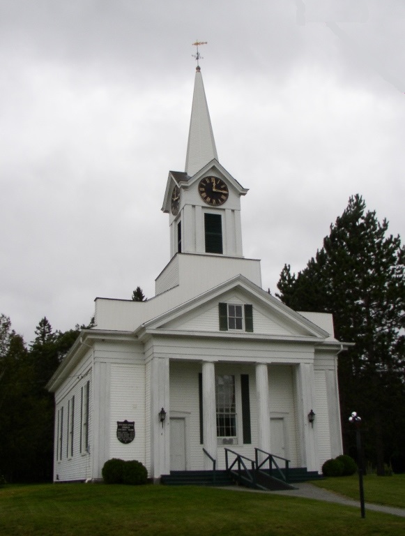
Church near the Village Common (2004)
This fishing and summer residential community projects two peninsulas (Dyer Neck and Petit Manan Point) divided by Dyer Bay into coastal waters.
A small section of Penobscot Indian Territory is located at Dyer Harbor on Dyer Neck.
The Point (almost an island) and adjoining Bois Bubert Island in Milbridge are protected by the Petit Manan National Wildlife Refuge. The 2166-acre Point includes jack pine, heath peatlands, blueberry barrens, old hay fields, marshes, and cedar swamps.
The main village lies at the head of Gouldsboro Bay on U.S. Route 1.
Form of Government: Town Meeting-Select Board.
Additional resources
Greenan, John T. ed. Way Down East in Maine; The Story of a Pioneer Family as Told by Themselves. Morristown, N.J. Compton Press. c1958.
Just a Souvenir. Steuben, Me. E. C. Tripp and G. A. Smith, 1906. [University of Maine, Raymond H. Fogler Library, Special Collections]
Limeburner, Grace M. Grindle. The Folks of Stuben [sic] Johnsboro [sic] Jonesport and Nearby Towns. North Brooksville, Me. G. Limeburner. 1951-1953?
Milliken, James Alphonso. The Narraguagus Valley: Some Account of its Early Settlement and Settlers. Machias, Me A.J. Huston. 1886.
National Wildlife Service. “Petit Manan National Wildlife Refuge.” http://library.fws.gov/Refuges/petit_manan.pdf (accessed April 5, 2012)
National Register of Historic Places – Listings
Moore, Henry D., Parish House and Library
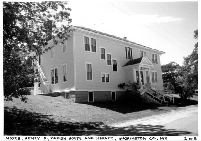 [3 Rogers Point Road] The 1911 Henry D. Moore Parish House and Library is a two-story, hip roofed frame building mat is sheathed in clapboards. It was given to the town by Steuben native Henry D. Moore, a successful businessman and financier in New York and New Jersey.
Historically Steuben’s residents were chiefly engaged in seafaring, farming and lumbering. Population peaked in 1860 with 1,191 persons, but by 1910 this figure had declined to 890. Among those who were born in Steuben but left to pursue their careers elsewhere was Henry Dyer Moore (1842-1930). After his service as a corporal in the 2nd Maine Cavalry, Moore went to work as a bookkeeper with W. E. Garrett and Sons of Philadelphia, a manufacturer of snuff. In 1893, Moore bought the business, and over the next eighteen years he was closely associated with the development of the American Snuff Co. During this period he also financed the construction of the 160 mile Montana Railroad.
Moore’s gift of a memorial building to his native town illustrates a common pattern of philanthropy in the period from the late 19th century up to the Great Depression. In Maine donations were frequently made through library buildings, although in some cases , as in Steuben, a multi-purpose facility that included a library and community meeting space was provided. The Parish House and Library included a large assembly room, completely furnished kitchen, and a classroom on the first floor.
The building continued to serve in its original capacity in 2017. Although modest in design, the Parish House and Library is distinguished in the local building context by its hip roof with broad eaves supported by exposed rafters. It stands in marked contrast to the nearby Greek Revival style Steuben Union Church with its projecting portico and three stage tower. [Amy Cole Ives photo]
Source: United States. Department of the Interior. National Park Service. https://npgallery.nps.gov/pdfhost/docs/nrhp/text/81000068.PDF (accessed March 9, 2017)
Windswept
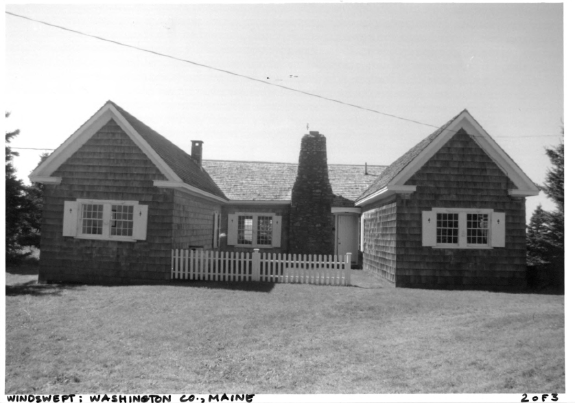
[421 Petit Manan Point Road] Windswept was the seasonal cottage of Mary Ellen Chase (1887 -1973), the noted educator, author and lecturer. She is considered by many literary critiques to be second only to Sarah Orne Jewett in her ability to capture the history and particular atmosphere of the coast of Maine and its people, yet her work also encompassed educational pedagogy, and biblical criticism.
Located on the shore of Petit Manan Point in the town of Steuben, Windswept is a modest cottage with sweeping views of the coast of Maine, including the Schoodic Peninsula and Mount Desert Island. The isolated cottage provided Ms. Chase with the tranquility and isolation she needed to write, and in turn it also provided the inspiration for the setting of Windswept (1941), her best selling novel about immigration and integration in old settled Maine communities. [Christi A. Mitchell photo]
Source: United States. Department of the Interior. National Park Service. https://npgallery.nps.gov/pdfhost/docs/nrhp/text/07000411.PDF (accessed March 9, 2017)
Atkinson-Koskinen Site 45.13, Address Restricted