")
The New Vineyard Mountains from Route 43 in Starks (2003)

Location Map for Starks
| Year | Population |
|---|---|
| 1970 | 323 |
| 1980 | 440 |
| 1990 | 508 |
| 2000 | 578 |
| 2010 | 640 |

Population Trend 1800-2010
| Geographic Data | |
|---|---|
| N. Latitude | 44:44:14 |
| W. Longitude | 69:57:17 |
| Maine House | District 112 |
| Maine Senate | District 3 |
| Congress | District 2 |
| Area sq. mi. | (total) 31.9 |
| Area sq. mi. | (land) 31.4 |
| Population/sq.mi. | (land) 20.1 |
County: Somerset
Total=land+water; Land=land only |
|
")
Veterans Memorial (2003)
")
[STARKS] a town in Somerset County was settled in 1772 and incorporated on February 28, 1795 from Lower Sandy River Plantation.
The once larger tract has been reduced by ceding land to Industry (1822), Mercer (1835, 1865), and Norridgewock (1907).
Named for the Battle of Bunker Hill participant and hero of the Battle of Bennington, General John Starks, it was the one hundredth town incorporated in the District of Maine.
")
Sandy River Near the Early Waugh Settlement (2003)
")
Waugh Settlement (2003)
James Waugh was the first settler along the Sandy River. He was clearly the “Man of Starks” considering his community activities and the large family that continued to live there in the 20th century.
")
Mill Site on the Lemon Stream
In 1784 Luke Sawyer built a sawmill on the Lemon Stream and a settlement called Sawyer’s Mills developed around it, later to be called Starks Village.
A lumber mill operated on the site until the flood of 1954 destroyed it.
At the end of the 20th century, a low head hydroelectric power unit occupied the old foundation.
Lemon Stream, with a typical “old swimming hole” often used after haying most of the day, empties into the Sandy River.
")
Grange Hall (2003)
 N44° 44' 38.79\" W69° 54' 15.10\"")
Restored Grange (2018) @
Starks once boasted a canning factory to which farmers would bring corn, squash, pumpkins, and other produce each fall.
It opened in 1916, having moved from Carmel at the urging of local farmers and the town, which provided land for its construction. The “corn shop” as it was known, closed in 1964.
The once abandoned Grange Hall, as in most farming communities, was the site of many community dances and socials at least through the 1950’s. A successful restoration has made the Grange Hall a relevant supporter of the local farm economy.
The winding Sandy River, once the site of several ferry crossings, constitutes the town’s eastern boundary.
")
Starks Elementary School (2003)
 N44° 44' 38.79\" W69° 54' 15.10\"")
Town Office/Comm Ctr (2018) @
")
Town Office (2003)
Since 2003 the Grange Hall has been restored and the former school now houses a community center and the town office.
")
Cemetery, River Road (2003)
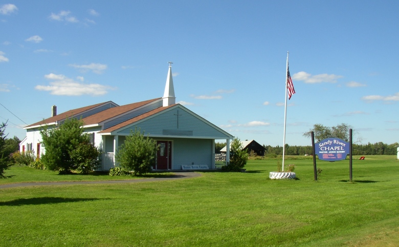
Sandy River Chapel (2003)
A small chapel is located near an old cemetery on the River Road. The headstones note deaths in the 1830’s, possibly some of the early settlers.
Maine Routes 43 and 134 join near the village on the Lemon Stream, a tributary of the Sandy River.

Farm 1940’s. In 2003 all that remained was an overgrown stone cellar wall with no trace of the farm.
Form of Government: Town Meeting-Select Board.
Additional resources
Allen, William. History of the Town of Starks: from the first settlement in 1774 to 1869 inclusive. Anson, Me. E. Adams. 1974 (Wilton, Me. Wilton Printed Products)
Hanson, J. W. (John Wesley) History of the old towns, Norridgewock and Canaan, comprising Norridgewock, Canaan, Starks, Skowhegan, and Bloomfield, from their early settlement to the year 1849; including a sketch of the Abnakis Indians. (with a new introduction / by Jennie Hilton) [University of Maine, Raymond H. Fogler Library, Special Collections; Maine State Library] [Also available to download as an e-book or PDF free from https://archive.org/details/historyofoldtown00hans] (accessed April 6, 2014)
Heritage Project, Starks, Me. A Ride on the Brick Steamer … a glimpse into Starks’ past. Starks Human Development Project.Starks, Me. The Project, 1979-
Hilton, Ernest W. The People & Places of Starks. Starks, Me. Starks Historical Society, Inc. c1995. (State College, PA. Printed by Jostens)
Peterson, Erland R. A Passel of Memories. Starks, Me. E.R. Peterson. c1999. (Dover, N.H. Printed for Erland R. Peterson by Odyssey Press, Inc.)
Starks Bicentennial Committee. Starks, Maine Bicentennial 1995 Calendar. Starks. 1994.