Cape Island south of Cape Newagen, summer home of actress Margaret Hamilton (2013)

Location Map for Southport
| Year | Population |
|---|---|
| 1970 | 473 |
| 1980 | 598 |
| 1990 | 645 |
| 2000 | 684 |
| 2010 | 606 |
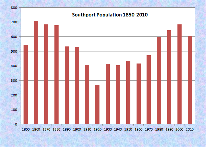
Population Trend 1850-2010
| Geographic Data | |
|---|---|
| N. Latitude | 43:49:23 |
| W. Longitude | 69:40:02 |
| Maine House | District 89 |
| Maine Senate | District 13 |
| Congress | District 1 |
| Area sq. mi. | (total) 13.9 |
| Area sq. mi. | (land) 5.4 |
| Population/sq.mi. | (land) 127.0 |
County: Lincoln
Total=land+water; Land=land only |
|
 [SOUTH-port] is an island town in Lincoln County, incorporated on February 12, 1842 from a portion of the town of Boothbay.
Born under the name of Townsend, the town changed to Southport on June 12, 1850.
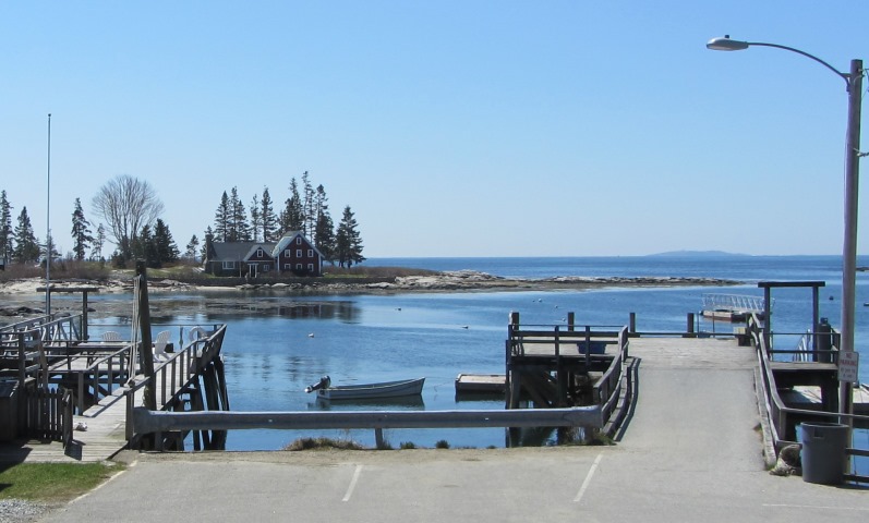
Located between Sheepscot Bay and Booth Bay, it is connected by a swing bridge to the town of Boothbay Harbor, and the casual visitor might not assume the town was on an island.
At the height of the summer, traffic is often backed up at the bridge as boats pass. Townsend Gut is the narrow waterway that separates the two towns. It is a shortcut from Boothbay Harbor to the Sheepscot River.
 N43° 50' 32.68\" W69° 39' 16.38\"")
Bridge to Southport (’13) @
 N43° 50' 33.32\" W69° 39' 15.22\"")
Townsend Gut (2013) @
Cape Newagen, at the southern tip of Southport Island, was apparently visited very early by European fishermen, including those who frequented nearby Damariscove Island.
The Cuckolds Light, near Cape Newagen, warns of ledges.
According to Dorothy Simpson,
Newagen is an ancient name, intimately involved with the history of the state. The settlement by that name had been established at least two years before Christopher Leavett visited it in 1623 and reported that the Indians came there to trade their furs to an Englishman named Coke. (p. 115)
 N43° 47' 10.65\" W69° 39' 18.62\"")
Cape Newagen (2013) @
 N43° 47' 11.43\" W69° 39' 17.92\"")
The Cuckolds Light (2013) @
At least two interpretations exist of the native name Newagen. Eckstorm, after some agony, concludes it means “where one crosses the land” or “an interrupted route.” Bond, however, makes it to be “Place where there is a swift current.”
 N43° 50' 36.03\" W69° 38' 23.68\"")
Squirrel Island in Boothbay Harbor (2013) @
")
Cottages on Squirrel Island (2001)
Squirrel Island is a self-governing village corporation within the town. A ferry service makes the short trip from Boothbay Harbor to the island several times a day, except in winter. No automobiles are allowed, though residents may use small carts to deliver groceries to their cottages along well kept walkways. Auburn publisher-journalist Frank L. Dingley helped develop the summer colony.
Originally a fishing and lumbering area, some prosperous gentlemen from Lewiston discovered its vacation potential, bought Squirrel Island, and eventually the somewhat exclusive community was created.
 N43° 49' 23.67\" W69° 40' 37.50\"")
General Store (2013) @
 N43° 49' 23.90\" W69° 40' 37.78\"")
Veterans Memorial (2013) @

The Store Early 1900’s
")
The Store (Undated)

The Old Casino
The general store in West Southport village has been an institution for over a century. It now contains images and artifacts of its, and the town’s, past. [Thanks to owner Oliver Cusano for these images.]
Environmentalist and author Rachel Carson lived on Southport Island and was inspired by the creatures living in and near the sea. The “Wicked Witch of the West” actress Margaret Hamilton summered on Cape Island in the mid-20th century. She appeared in more than 100 movie and played Lakewood Theater in Madison, the Ogunquit Playhouse and what is now the Maine State Theater in Brunswick.
 N43° 49' 24.59\" W69° 40' 33.28\"")
Southport Post Office (’13) @
 N43° 49' 23.77\" W69° 40' 35.74\"")
Fire Department (2013) @
 N43° 47' 21.22\" W69° 39' 23.97\"")
Memorial Library (2013) @
During the War of 1812, the British frigate Bulwark visited Southport Island and landed a group of marines at what is now Hendrick’s Harbor. They were beaten back by the local militia.
While the Civil War raged, the Southport fishing vessel Archer was captured by rebel privateers. Its crew was captured and held prisoner for an extended period.
 N43° 49' 35.83\" W69° 40' 15.74\"")
Town Office (2013) @
 N43° 49' 27.61\" W69° 40' 29.53\"")
Hendricks Hill Museum @
 N43° 49' 23.55\" W69° 40' 35.77\"")
Central School (2013) @


<== Up West Downeast ==>
Form of Government: Town Meeting-Select Board.
Additional resources
Bond, C. Lawrence. Native Names of New England Towns and Villages.
Clifford, Harold B. The Boothbay Region, 1906 To 1960. Freeport, Me. Bond Wheelwright Co. c1961.
Eckstorm, Fannie Hardy. Indian Place Names of the Penobscot Valley and the Maine Coast.
Greene, Francis Byron. History Of Boothbay, Southport, And Boothbay Harbor, Maine. Somersworth. New England History Press. 1984.
Lepper, Ruth Rhoads. Southport Historical Series: A Pictorial History Of Southport. West Southport, Me. R.L. Gardner. 1976.
*Maine. Historic Preservation Commission. Augusta, Me. Text and photos from National Register of Historic Places: http://pdfhost.focus.nps.gov/docs/nrhp/text/xxxxxxxx.PDF and http://pdfhost.focus.nps.gov/docs/nrhp/photos/xxxxxxxx.PDF
Cuckolds Light Station: 02001413.PDF
Hendricks Neck Light Station: 87002024.PDF
McGrail, Sarah Sherman. Southport: The War Years: An Island Remembers. Southport, Me. Cozy Harbor Press. c1996.
The Old House Book and the Families Who Lived in Them. Southport, Me. Southport Historical Society. c197?
Southport History Committee. Historical Gleanings From Cape Newagen Island, Townsend, Southport. Southport History Committee. Boothbay Harbor, Me. Harbor Print Shop. 1976.
Simpson, Dorothy. The Maine Islands in Story and Legend.
Thistle, Scott. “Margaret Hamilton’s Wicked Maine Connection.” Portland Press Herald. December 7, 2018. pp1, A8.
National Register of Historic Places – Listings
Cuckolds Light Station
 N43° 47' 11.46\" W69° 39' 17.94\"")
Cuckolds Light from Cape Newagen (2013) @
The Cuckolds Light Station is significant for its association with federal government’s efforts to provide an integrated system of navigational aids and to provide for safe maritime transportation in the United States.
The historic integrity of the station has been compromised by the destruction of all the station structures except the fog signal building and light tower built upon it. Still, the fog signal structure is unique because of its granite pier construction built to protect the station from storm waves and its later modification to a light tower.
Boothbay Harbor was a busy fishing port in the 19th and early 20th century. The barren rock upon which the Cuckold station is located was first marked by a wooden tripod daymark. Because the daymark was of little use at night or in foggy weather, a fog signal station was established in 1892. In 1904 the coal fired 1901 fog horn was replaced by a more efficient oil powered mechanism. A light tower was added in 1907 due to increased fishing vessel traffic in the bay. The station was automated in 1975.
The Lighthouse Board Report for 1890 described the need for a fog-signal station at Cuckolds as follows: The Cuckolds consist of two rocky islets rising about 15 feet above high water in the westerly edge of the channel at the entrance to Booth Bay. . . . They are dangerous of approach on their southern side on account of the reefs in that direction, and the shoals also extend half a mile to the westward of the western rock, … but the eastward side of the eastern rock is quite bold-to. The flood current sets right on these rocks.They are much dreaded by mariners in thick weather and are a great peril to a large number of vessels, as it is estimated that from three to four thousand enter the bay for refuge in Booth Bay Harbor.*
In 2006, a group of local citizens organized as the Cuckolds Fog Signal and Light Station Council became owners of the property. Thereafter the Inn at Cuckolds Lighthouse was opened, available by appointment to visitors and overnight guests.
Hendricks Head Light Station
[Hendricks Head, Southport Island, West Southport] The Hendricks Head Light Station is a virtually intact complex whose design clearly illustrates the technological and architectural features of the early 1870s phase of lighthouse construction in Maine. Located behind a shallow rock ledge on the east side of the mouth of the Sheepscot River, the station has integrity of design, setting and association characteristic of an historic property.
 N43° 49' 28.54\" W69° 41' 7.26\"")
Hendricks Head Lighthouse (2015 @
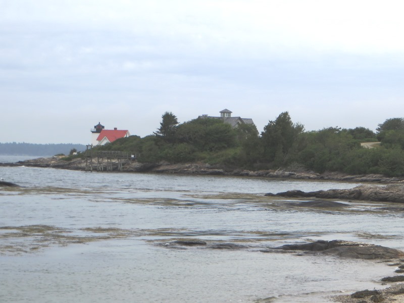
This light station was established in 1829 as a guide to the Sheepscot River and the important harbor at Wiscasset. Incorporated in 1802, Wiscasset enjoyed a brief period of prosperity in the early 19th century resulting in large part from shipbuilding at its deep sheltered harbor and from maritime commerce. Its sister settlements on the Sheepscot, including Southport, Cape Newagen and Hendricks Head, were also very dependent on the local fishing industry and later in the century on tourism.* [2015 photos]
In 2015, no direct access was allowed by the building’s current owners, who have restored the structure for viewing from the nearby beach.