
Location Map South Portland
| Year | Population |
|---|---|
| 1970 | 23,267 |
| 1980 | 22,712 |
| 1990 | 23,163 |
| 2000 | 23,324 |
| 2010 | 25,002 |
| Geographic Data | |
|---|---|
| N. Latitude | 43:37:58 |
| W. Longitude | 70:17:08 |
| Maine House | Dis 31,32,33 |
| Maine Senate | District 29 |
| Congress | District 1 |
| Area sq. mi. | (total) 14.3 |
| Area sq. mi. | (land) 12.0 |
| Population/sqmi | (land) 2,084 |
| County: Cumberland
Total=land+water; Land=land only |
|

Population Trend 1900-2010
")
First United Methodist (2012)
")
South Portland High (2012)
") [PORT-lnd] is a city in located in Cumberland County, at the southern edge of Casco Bay. It was settled in 1630 and incorporated as a town on March 15, 1895 from land set off by Cape Elizabeth. Three years later it became a city.
[PORT-lnd] is a city in located in Cumberland County, at the southern edge of Casco Bay. It was settled in 1630 and incorporated as a town on March 15, 1895 from land set off by Cape Elizabeth. Three years later it became a city.
Maud Park Wood, first president of the League of Women Voters, lived in South Portland. It is the birthplace of 20th century U.S. Representative James Oliver. It was also the residence of U.S. Representative Frank Coffin.
A residential community serving the greater Portland area for over a hundred years, the City has developed independent economic resources.
")
Downtown (2012)
")
Fire Department (2012)
")
Post Office (2012)
")
City Hall (2012)
Southern Maine Community College campus includes Fort Preble, named for Commodore Edward Preble.
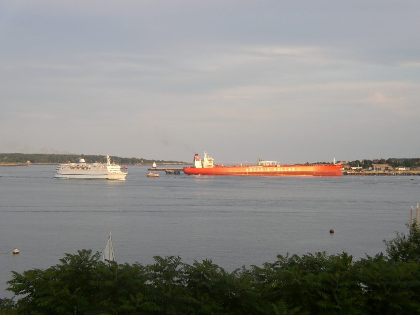
In the 1940’s it became a substantial shipbuilding center. It is currently home to the Portland Pipeline Company, with its huge oil tank farm and tanker docking facilities, and to the Maine Mall, a huge shopping area serving a wide area of southern Maine.
")
Tanker at Berth (2012)
")
Fuel Storage Tank (2012)
")
Railroad Yard (2003)
")
Spring Point Light (2001)
South Portland lies on the south bank of the Fore River and fronts on Portland Harbor. It is part of the Port of Portland and home to a major railroad yard and fuel tank storage facility.
The state’s fourth largest community by population behind Portland, Lewiston and Bangor, surpassing Auburn in the 1990 U.S. Census. Maine Route 77 winds through the city.
")
National Guard Armory
(2012)
")
Mahoney Middle School (2012)
")
Police & Fire Building (2012)
Mahoney Middle School, whose 1924 building once housed the high school, has adapted a classic building to continue functioning as an educational institution.
An A26-B Invader bomber crashed into the Redbank mobile home park in 1944, killing the two crew members and 17 others on the ground. It has been called Maine’s worst air disaster.
Mill Cove is a nature preserve of 31 acres of tidal flats, salt marsh and upland areas visited by many bird species. Mill Creek Park, in the downtown area, hosts a bandstand and a large resident population of gulls and ducks.


Form of Government: Council-Mayor-Manager.
Additional resources
See also Cape Elizabeth
DiPhilippo, Kathryn Onos. South Portland: a nostalgic look at our neighborhood stores. South Portland, Me. Barren Hill Books. c2006.
Ledman, Paul J. A Maine Town Responds: Cape Elizabeth & South Portland in the Civil War. Cape Elizabeth, Me. Next Steps Publishing. 2003.
*Maine. Historic Preservation Commission. Augusta, Me. Text and photos from National Register of Historic Places: http://pdfhost.focus.nps.gov/docs/nrhp/text/xxxxxxxx.PDF and http://pdfhost.focus.nps.gov/docs/nrhp/photos/xxxxxxxx.PDF
Lightship No. 112, NANTUCKET: 89002464.PDF
Portland Harbor Breakwater Light: https://npgallery.nps.gov/pdfhost/docs/nrhp/text/73000238.pdf; “Portland Breakwater, Me.” http://www.lighthousefriends.com/light.asp?ID=544
Seavey-Robinson House: https://npgallery.nps.gov/NRHP/GetAsset/2261ef2c-2492-4ac9-802d-1862a3ce0f12?branding=NRHP
Spring Point Ledge Light Station: 87002279.PDF; also https://npgallery.nps.gov/NRHP/GetAsset/d58ab270-31f6-44
State Reform School Historic District: https://npgallery.nps.gov/GetAsset?assetID=5059b46d-b885-473d-a8e8-21b24bd44c8a
Smith, Jared A. Sketch of Portland Harbor, Maine showing the improvements made in 1866-86, also projected improvements. [cartographic material] Washington, D.C. Government Printing Office. 1886. (including Knightsville and Ferry Village in South Portland)
South Portland and Cape Elizabeth. Dover, N.H. Arcadia Publishing. 1995. (pictorial)
South Portland History Committee. History of South Portland, Maine. South Portland, Me. The Committee. 1992. South Portland, Me. Brownie Press.
National Register of Historic Places – Listings
Lightship No. 112, NANTUCKET
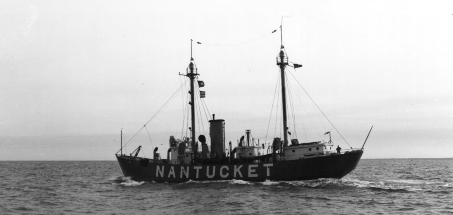
Nantucket Lightship No. 112 (1989)
The 1936 lightship Mo. 112, known by her former official designation of “Nantucket,” is one of a small number of preserved historic American lightships. Essential partners with lighthouses as aids to navigation along the coast of the United States, lightships date to 1820 when the first vessel to serve as an aid to navigation was commissioned. Lightships left in the United States date from 1902 to 1952, when the last was built and launched. The nation’s most significant lightship station, established in 1854, was for transatlantic voyages at Nantucket Shoals. Nearly 47 miles out to sea, this remote and dangerous station marks the limits of the dangerous Nantucket Shoals and the eastern end of the Ambrose shipping channel into New York harbor.
") The Nantucket lightship was the last beacon seen by vessels departing the United States, and the first beacon entering the United States. Eleven lightships were assigned to Nantucket Shoals. It was the last United States lightship station in operation, outlasting all others with a lightship at anchor until 1983, eight years after most others were retired.
The Nantucket lightship was the last beacon seen by vessels departing the United States, and the first beacon entering the United States. Eleven lightships were assigned to Nantucket Shoals. It was the last United States lightship station in operation, outlasting all others with a lightship at anchor until 1983, eight years after most others were retired.
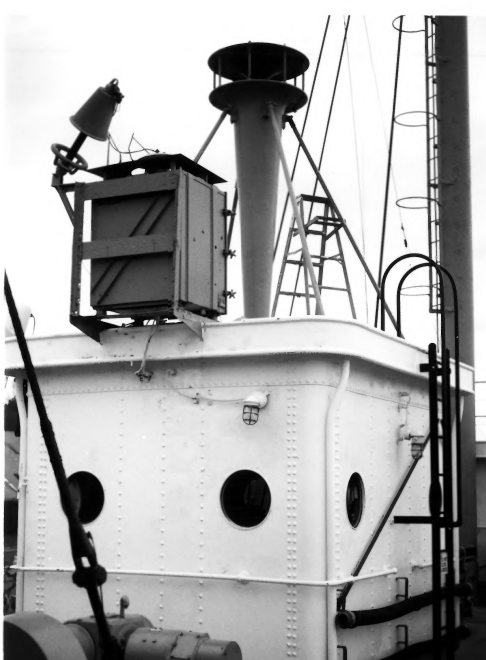
Nantucket Lightship No. 112 Fog Signal (1989)
No. 112 is the oldest surviving lightship to have served on the Nantucket station, marking it for 39 years. The Nantucket lightship station was the scene of one of America’s greatest lightship disasters. In 1934 the RMS Olympic, sister of Titanic, rammed and sank Lightship No. 117, killing seven of the 11 man crew. The White Star Line paid $500,000 in compensation. $300,956 was spent to build No. 112 as an “indestructible” replacement for the lost No. 117. Because of this, No. 112 is perhaps the best known of America’s lightships.
Lightship No. 112 is maintained in excellent, fully operational condition by her crew. Only two other lightships in the United States can claim that distinction, the two 1951-built Coast Guard ligttships WLV-604 and WLV-605. Only No. 112 and WLV-605 are capable of moving under their own power. * [James P. Delgado photos]
[After a brief stay in South Portland, the vessel visited several other ports seeking a permanent home.] “She was purchased in October 2009 by the United States Lightship Museum (USLM) under the leadership of Robert Mannino, Jr. for $1 and arrived under tow in Boston Harbor on 11 May 2010. She will be restored in two phases over the next several years, a job that will cost $1 million. She is currently undergoing renovations as a floating museum, but is open to the public at Boston Harbor Shipyard and Marina at 256 Marginal Street in East Boston, Massachusetts.”
From “United States lightship Nantucket (LV-112)” at https://www.revolvy.com/main/index.php?s=United+States+lightship+Nantucket+(LV-112) [accessed June 16, 2018]
Portland Breakwater Light (“Bug Light”)
 N43° 39' 20.10\" W70° 14' 5.88\"")
Portland Harbor “Bug” Light (2014) @
[Northeast end of Portland Breakwater in Portland Harbor] This Greek Revival structure was first built in 1855. The rebuilding in 1875 did not alter the design or its character. The Light is unique in style and construction. Built to communicate the location of Portland Breakwater to ships at sea, it also indicates the concern of 19th century Americans to make an essentially functional structure aesthetically pleasing. Its Greek Revival styling would have integrated well into the panorama of Portland in 1855.
")
It also represents Maine’s sea-going heritage in the 18th and 19th centuries. It and its sister lighthouses along Maine’s rocky coasts stood as symbols of commercial prosperity derived from shipping. The breakwater itself was completed in 1838, to protect the inner harbor from damaging swells at high tide.
The structure was abandoned in 1943. By 2002 the South Portland Rotary Club and Spring Point Ledge Light Trust had refurbished the lighthouse. It was relighted as a private aid to navigation.*
Seavey–Robinson House
")
Seavey-Robinson House (2018)
[580 Ocean Street] Now located in a built-up urban section of South Portland, this “Carpenter Gothic” farm cottage is a rare survivor. This area across the Fore River from Portland was farming country. Joseph Seavey was the original owner and a carpenter in what was then part of Cape Elizabeth. The house he built, with its elaborate decorative woodwork, served as a display of his abilities as a builder and demonstrated his knowledge of the latest picturesque styles.
By 1860 Seavey had moved his practice to what was then called Knight’s Village, now the center of South Portland. Elipalet C. Robinson acquired the house in 1864 when developing transportation facilities put the area in commuting distance to Portland. Robinson worked for C. E. Jose and Company in the city. The Robinson’s owned the house well into the 20th century. The Gothic cottage, particularly in a rural context, is comparatively rare in Maine. It is very unusual to find one in what is now an urban setting.*
Spring Point Ledge Light Station
") [Spring Point Ledge, Portland Harbor] Above a dangerous reef in Portland’s inner harbor, the 1897 Spring Point Ledge Light Station is one of Maine’s three surviving “spark plug” lights. It is one of two lights that aid navigation in Portland Harbor. The other, Portland Breakwater (Bug Light), was established in 1855.
[Spring Point Ledge, Portland Harbor] Above a dangerous reef in Portland’s inner harbor, the 1897 Spring Point Ledge Light Station is one of Maine’s three surviving “spark plug” lights. It is one of two lights that aid navigation in Portland Harbor. The other, Portland Breakwater (Bug Light), was established in 1855.
In the latter half of the 19th century there was considerable local clamor for a permanent light to mark this ledge in Portland’s busy harbor area. The ledge was the site of a of wrecks and accidental groundings. After repeated requests, Congress authorized construction of the light station in 1895, becoming operational in May 1897. The light was automated in 1960. The station’s distinctive character illustrates one important late 19th century variant on the design and construction of light stations.*
State Reform School Historic District
 N43° 38' 10.98\" W70° 18' 29.40\"")
Old Administration Building (2015) @
 N43° 38' 14.76\" W70° 18' 19.68\"")
A. R. Gould School in the District (2015) @
Westbrook Street] The State Reform School for Boys is was the first institution of its kind in Maine. The buildings in the district, largely unaltered, reflect important developments in the efforts to rehabilitate wayward boys during the late 19th and early 20th centuries.
The main building, built 1853, was designed by one of the leading architects in New England, Gridley J. F. Bryant of Boston. Two important Maine architectural firms, John Calvin Stevens of Portland and Coombs and Gibbs of Lewiston, provided designs for later buildings.
Maine’s state legislature authorized construction of a reform school for boys on August 20, 1850. It was built to house 300 inmates. Bryant included a specialization in prison design in his large practice. This reform school building is similar to his Charles Street Jail in Boston. It features a cruciform plan with cells in wings that radiate from a central core containing classrooms, workrooms, and eating facilities.
The exterior design, termed “Elizabethan”, featured Tudor arches and octagonal stair towers. Throughout the 19th century the school changed in response to more progressive theories of juvenile reform. Three departments intended to provide useful employment: farming, mechanical (shoemaking and a tailor’s shop) and domestic (cleaning, baking, laundry). Originally, the boys were located in unheated cells. In 1871 steam heating was introduced and three years later the cells were replaced by dormitories.
 N43° 38' 14.16\" W70° 18' 19.74\"")
“Cottages” in the Historic District (2015) @
Another major change was the introduction of the “Cottage or Family system” in which the boys were housed in smaller dormitories, called cottages. As explained in the 44th Annual Report, “The boys of each cottage, living together as one family with their cottage father, mother and teacher, are surrounded by the comforts and wholesome influences of home itself…” Portland architect John Calvin Stevens designed cottage numbers one and two, completed in 1893 and 1897, respectively. A major enlargement of the institution occurred in the early 1900s. Lewiston architects Coombs and Gibbs designed more cottages in 1903-04. They also prepared plans for a large new barn and, in 1905-06; designs to remodel the interior and exterior of the Administration Building.
Still used as a boys reform school, the institution has seen the addition of numerous other small structures following the cottage plan.*