")
The Deer Isle Bridge over Eggemoggin Reach between Sedgwick and Deer Isle (2003)

Location Map for Sedgwick
| Year | Population |
|---|---|
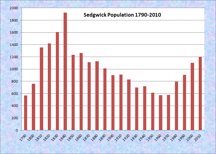
| 1970 | 578 |
| 1980 | 795 |
| 1990 | 905 |
| 2000 | 1,102 |
| 2010 | 1,196 |
Population Trend 1790-2010
| Geographic Data | |
|---|---|
| N. Latitude | 44:19:43 |
| W. Longitude | 68:39:14 |
| Maine House | District 133 |
| Maine Senate | District 7 |
| Congress | District 2 |
| Area sq. mi. | (total) 31.1 |
| Area sq. mi. | (land) 27.0 |
| Population/sq.mi. | (land) 44.3 |
County: Hancock
Total=land+water; Land=land only |
|
[SEJ-wik] is a town in Hancock County, incorporated on January 14, 1789 from the township of Naskeag or T4, EPR.
")
Federal style house on Route 175 near the Benjamin River (2003)
Permanently settled in 1759 by Andrew Black, the town’s modern name is in honor of Major Robert Sedgwick who captured three important trading posts from the French: Pentagoet (Castine) and Saint John and Port Royal, now in Canada.
")
Sedgwick Elementary School

Penobscot Bay and the Camden Hills westerly off Route 15 in Sedgwick
In the 19th century the Benjamin River provided tidal power to a grist mill near Sedgwick village. In addition the town had another grist mill, some saw mills, and two silver mining companies. Shipbuilding was yet another industry. Other villages are North Sedgwick, Sargentville, Black Corner, and Grays Corner.
")
Deer Isle Bridge (2001)
")
Deer Isle Bridge from Sedgwick (2003)
Note the change in the landscape in just two years!
Eggemoggin Reach is a long stretch of water between the mainland and Deer Isle and Little Deer Isle. It islands are connected to the mainland by a spectacular suspension bridge, one end of which is in Sedgwick. A “reach” is a body of water that allows sailing vessels to sail effectively under a wind generally coming on its beam (side).
The southern portion of Sedgwick fronts on Eggemoggin Reach and the broad lower portion of the Benjamin River.
The original name, Naskeag, derives from the Indian term for “the end” or “the extremity.”
Naskeag Point, now in the adjoining town of Brooklin, extends into Blue Hill Bay.
Form of Government: Town Meeting-Select Board.
Additional resources
Howes, Mary Abigail Cole, 1837-1924. Diary, 1854 to 1866, Mary Abigail Cole (Howes), and early life story of Alice Howes Blair. D.D. Blair. 1998. [University of Maine, Raymond H. Fogler Library, Special Collections; Maine State Library]
Life and Times in a Coastal Village: Sedgwick, Maine 1789-1989. Sedgwick, Me. Bicentennial Committee. 1989.
*Maine. Historic Preservation Commission. Augusta, Me. Text and photos from National Register of Historic Places: http://pdfhost.focus.nps.gov/docs/nrhp/text/xxxxxxxx.PDF and http://pdfhost.focus.nps.gov/docs/nrhp/photos/xxxxxxxx.PDF
First Baptist Church: 73000109.PDF
Sedgwick Historic District: 94001550.PDF
Sedgwick, Maine Bicentennial 1763-1963, August 2-3-4. Sedgwick, Me. Sedgwick Maine Bicentenial Committee. 1963? [University of Maine, Raymond H. Fogler Library, Special Collections]
Varney, George J. A Gazetteer of the State of Maine. 1886. p. 508.
National Register of Historic Places – Listings
First Baptist Church
")
Sedgwick First Baptist Church (1973)
[off Maine Route 172] The First Baptist Church of Sedgwick is the finest example of classic Greek Revival architecture on the Maine coast. Its elevated site together with its monumental Doric portico, reflecting a Grecian temple facade, and its stately belfry make a powerful statement of its style. The facade is finished in matched boards; the sides and rear are done in clapboards. There is a pilaster at each corner of the structure and three large windows on each side. The whole structure is topped with a steeple done in three sections. The top and most ornate section of the steeple, the belfry, has been removed. The building as a whole is structurally sound and, except for the portion of the steeple that was removed, has been well cared for by the congregation.
The significance of this structure is inn its architecture. It is one of the most sophisticated and impressive Greek Revival Churches in Maine. The church was designed by Benjamin S. Deane, a distinguished architect, who came to Bangor in the 1830s. From 1830 to 1850 Deane planned many Greek Revival Churches, the 1837 Sedgwick Church, the 1843 Blue Hill Congregational Church, the 1845 North Sedgwick Baptist Church and the Somesville Congregational Church. Deane designed the Sedgwick Baptist Church from a drawing by Asher Benjamin (1773-1845), a noted American architect.* [James P. Vickery photo]
Sedgwick Historic District
") [Junction of Maine Route 172 and Old County Road] The Sedgwick Historic District embraces a collection of late 18th and early 19th century structures and sites that constitute this coastal community’s original religious and governmental center. It contains the Town’s first meetinghouse and common, the first minister’s residence, an early cemetery, and a cattle pound (left), representing an unusual concentration of these important early features of Maine settlements. Permanent settlement of the lands within the original boundary of Sedgwick are thought to have begun in 1762 or 1763 although squatters were found to have taken up some property. The Town was incorporated on January 13, 1789, its name being chosen to honor Robert Sedgewick, the English Major General who had ousted the French from Pentagoet (Castine) in 1654.
[Junction of Maine Route 172 and Old County Road] The Sedgwick Historic District embraces a collection of late 18th and early 19th century structures and sites that constitute this coastal community’s original religious and governmental center. It contains the Town’s first meetinghouse and common, the first minister’s residence, an early cemetery, and a cattle pound (left), representing an unusual concentration of these important early features of Maine settlements. Permanent settlement of the lands within the original boundary of Sedgwick are thought to have begun in 1762 or 1763 although squatters were found to have taken up some property. The Town was incorporated on January 13, 1789, its name being chosen to honor Robert Sedgewick, the English Major General who had ousted the French from Pentagoet (Castine) in 1654.
")
Two years after incorporation the residents voted at town meeting to erect a meetinghouse and settle a minister. Later that year an additional fifty pounds was voted to build six schoolhouses and to clear school and ministerial lots. The meetinghouse location was at the geographical center of the Town, which at that time included Brooklin and part of Brooksville. The two acre parcel on which the building stands was given by one of the Proprietors, Benjamin Friend. This property, as well as the twenty-three acre parcel granted to the first settled minister, were bordered on the south by the existing County Road. Friend’s gift to the Town included sufficient space around the meetinghouse itself to create a Common whose characteristics were typical of those in many 18th and early 19th century Maine communities. The Common represents the first type of designed public open space that occurs in Maine. They had several distinguishing characteristics: 1) they were associated with the Congregational meetinghouse and owned by its members; 2) they were relatively small, but centrally located; and 3) they may have been leveled for the purposes of public gatherings, but were not otherwise improved until the late 19th century. In 1849 when the Town residents voted to convert the meetinghouse, which had ceased to function in a religious capacity, into a Town House.
")
Several changes occurred in the district during the second half of the twentieth century. The first was the acquisition in 1965 of the Merrill House by the local historical society. This important building was rescued by the society and converted into a museum. An outbuilding was subsequently constructed to house a pair of horse-drawn hearses, and in 1987 a former one-room schoolhouse was reassembled on the property. More recently, the Town reaffirmed its desire to continue using the Town House for governmental purposes.* [Kirk F. Mohney photos]