")
Mountain Ranges from the Saddleback Mountain Trail on the AT (2004)

Location Map for Sandy River Plantation
| Year | Population |
|---|---|
| 1970 | 73 |
| 1980 | 50 |
| 1990 | 64 |
| 2000 | 93 |
| 2010 | 133 |

Population Trend 1870-2010
| Geographic Data | |
|---|---|
| N. Latitude | 44:53:46 |
| W. Longitude | 70:33:26 |
| Maine House | District 112 |
| Maine Senate | District 17 |
| Congress | District 2 |
| Area sq. mi. | (total) 35.3 |
| Area sq. mi. | (land) 34.1 |
| Population/sq.mi. | (land) 3.9 |
| County: Franklin Total=land+water; Land=land only | |
")
is a plantation in Franklin County, organized for the last time on March 23, 1905, after being organized for election purposes in 1859. About 35 miles northwest of Farmington on Maine Route 4, south of Rangeley, the community marks the source of the Sandy River in the Sandy River Ponds at the south end of the township.
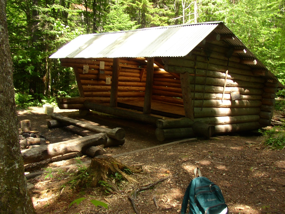
Adirondack style Shelter near Piazza Rock on the Saddleback Mountain Trail (2004)
The Appalachian Trail traverses the length of this 6,000-acre area with a lean-to at Sabbath Day Pond and a campsite at Little Swift River Pond, both in Township E.
In Sandy River, the AT has taken two different paths. One in 1949 (yellow dots) tracks north of Long Pond then down to Sandy River Ponds before heading northeast to Saddleback Mountain.
In 2005, the Trail (green dots) enters the plantation from the south, passing South Pond, then trending northeast to join the old trail east of Sandy River Ponds for the trek to Saddleback. (Click map to see the old and new AT path.)

Four Ponds Public Reserve Land, here and in Township E, lies just east of Mooselookmeguntic Lake. Access is by the Appalachian Trail off Route 17 in Township D or Route 4 in Sandy River.
Fishing and swimming are popular activities. Winter visitors pass through on snowmobiles on their way from Rangeley to Weld.
Form of Government: Assessors-Annual Meeting.

Saddleback Ski Slopes

Saddleback Ski Base Area

b

Small Pond Along the AT

Long View from the Trail

Rangeley Lake, Gull Pond, and Saddleback Lake
Cascade Stream Gorge sits on the east side of Route 4 in Sandy River Plantation, four mile south of downtown Rangeley. Access is by a short, but steep, driveway to a small parking lot. From there the falls and stream are a short hike on a path through woods and over rock outcrops. The gorge drops 90 feet into the stream. Rangeley Lakes Heritage Trust maintains the site. A map of trail options is posted at the trail-head [N44° 55′ 30.62″ W70° 36′ 35.80″].
Farther south on Route 4, the road turns east to the Sandy River Ponds on its north side. A primitive boat launch is near a dirt parking space. [N44° 53′ 41.08″ W70° 33′ 30.07″] By the signage, it is apparently a favorite spot for fishing.
")

")
")
 (2017)")
More Videos!
Photos and video content courtesy of Brady G. Williams 2007.
Topographic map was created from the following University of New Hampshire Dimond Library, Documents Department & Data Center, Historic USGS Maps of New England & New York, accessed 1/10/2008: Rangeley, ME Quadrangle (1949), http://docs.unh.edu/nhtopos/Rangeley.htm.
![]() <= South Appalachian Trail – click a boot North
<= South Appalachian Trail – click a boot North ![]() =>
=>