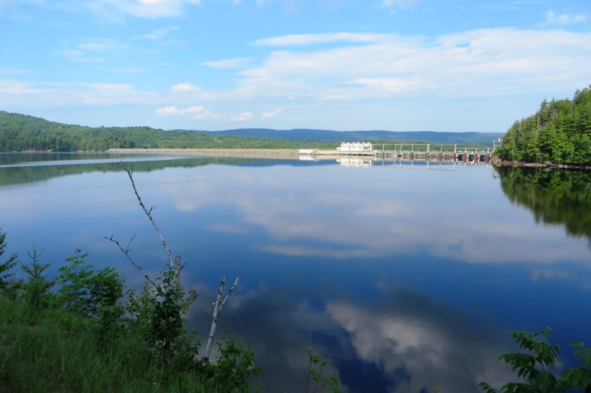
Wyman Lake and Dam from the Ridge Road in Pleasant Ridge (2014)

Location Map for Pleasant Ridge
| Year | Population |
|---|---|
| 1970 | 116 |
| 1980 | 99 |
| 1990 | 91 |
| 2000 | 83 |
| 2010 | 93 |
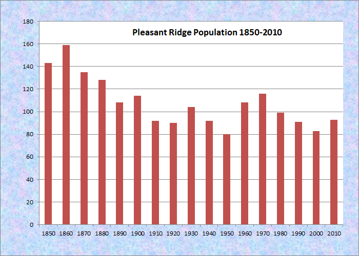
Population Trend 1850-2010
| Geographic Data | |
|---|---|
| N. Latitude | 45:06:88 |
| W. Longitude | 69:59:16 |
| Maine House | District 118 |
| Maine Senate | District 3 |
| Congress | District 2 |
| Area sq. mi. | (total) 24.1 |
| Area sq. mi. | (land) 22.1 |
| Population/sq.mi. | (land) 4.2 |
County: Somerset
Total=land+water; Land=land only |
|
is a plantation in Somerset County, formerly township T1 R2, settled in 1786.
It was organized for election purposes on October 17, 1840 and had its organization confirmed by the legislature in 1895.
Pleasant Ridge hosts four small ponds, clustered in its northern half: Bean, Brandy, Clear, and Jewett.
")
Pleasant Ridge, Wyman Dam and Lake from Moscow (2002)
The 18-acre Lost Pond has a maximum depth of 20 feet with Brook Trout as the primary fishery. It is isolated about one mile northeast of Rowe Pond in the northeast of the township. Lost Pond is accessible by a gravel road off the Rowe Pond Road. Jewett stream runs south through Jewett, Brandy and Clear ponds before emptying into the Kennebec River.
All ponds are on the western side of the “ridge” and are accessible by following the Ridge Road which merges into the Rowe Pond Road. The latter leads to a series of unimproved roads and to the ponds.
The “ridge” overlooks the community’s eastern boundary, which is Wyman Lake formed by the Wyman Dam and the Kennebec River.
In 2011 an application to place 39 wind turbines on the ridge was in process.
Carry Pond Road, on the right about two miles on the Ridge Road, leads to the several “carrying ponds” in Carrying Place Township and Carrying Place Town Township.
 N45° 4' 0.55\" W69° 57' 3.70\"")
To Carry Pond (2014) @
 N45° 3' 57.44\" W69° 57' 2.48\"")
Signs to the Ponds (2014)
Access to the plantation is across the from Bingham taking the Ridge Road north from Route 16. In about a mile on the right, just after the transfer station, is a short trail to Houston Falls.
 N45° 4' 9.73\" W69° 56' 11.93\"")
Pleasant Ridge Transfer Station (2014) @
 N45° 3' 57.45\" W69° 57' 2.48\"")
Small Park near Carry Pond Road (2014) @
Form of Government: Assessors-Annual Meeting.
Additional resources
Land Use Regulation Commission Application. Highland Wind Project, Somerset County, Maine. “Section 14 Historical and Archeological Reports.” https://www.maine.gov/dacf/lupc/projects/windpower/highland/Section14.pdf (accessed July 5, 2014)
Hunnewell, Robert E. Pleasant Ridge Plantation: “the way life used to be.” R.E. Hunnewell?. between 2000 and 2002. [Maine State Library]