Apparent Horse Cemetery on the Ridge Road (2013)

Location Map for Peru
| Year | Population |
|---|---|
| 1970 | 1,345 |
| 1980 | 1,564 |
| 1990 | 1,541 |
| 2000 | 1,515 |
| 2010 | 1,541 |
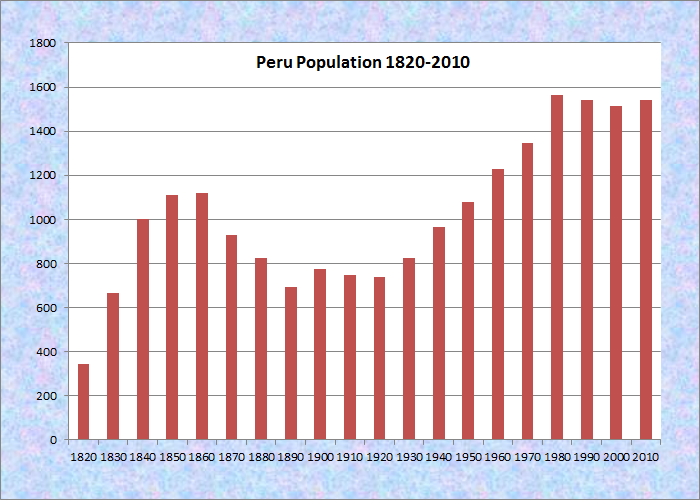
Population Trend 1820-2010
| Geographic Data | |
|---|---|
| N. Latitude | 44:28:30 |
| W. Longitude | 70:27:41 |
| Maine House | District 116 |
| Maine Senate | District 18 |
| Congress | District 2 |
| Area sq. mi. | (total) 47.8 |
| Area sq. mi. | (land) 46.9 |
| Population/sq.mi. | (land) 32.9 |
County: Oxford
Total=land+water; Land=land only |
|
[peh-RUU] is a town in Oxford County, settled in 1793 and incorporated on February 5, 1821 from Plantation Number One, also known as Thompsontown.
 N44° 31' 45.77\" W70° 28' 58.19\"")
@
 N44° 31' 31.52\" W70° 27' 53.07\"")
@
In the spirit of liberty and solidarity, the town was named for the South American country of Peru, which had just won its independence from Spain.
Three-mile long Worthley Pond is the focus of the Worthley Pond Association, an active community organization. A campground and bed & breakfast may be found at the pond.
 N44° 30' 28.54\" W70° 24' 26.68\"")
Rockameka Grange (2013) @
 N44° 30' 30.90\" W70° 24' 29.47\"")
The 1860 Union Hall (2013) @
Peru Center Road hosts two old community buildings, the 1904 Rochameka Grange Hall, and the Civil War era Union Hall.
The town is on the south bank of the Androscoggin River just below the Rumford–Mexico–Dixfield area. Its main village is West Peru, across the river from Mexico in the northern portion of the town. The locations below are all on Main Street in West Peru.
 N44° 31' 40.72\" W70° 27' 48.36\"")
Peru-Mexico Bridge (2013) @
 N44° 31' 34.72\" W70° 27' 51.28\"")
Peru Fire Department (’13) @
 N44° 31' 39.18\" W70° 27' 49.83\"")
Blaisdell’s Variety (2013) @
 N44° 31' 31.36\" W70° 27' 54.67\"")
Elementary School (’13) @
 N44° 31' 30.03\" W70° 27' 53.60\"")
Peru Town Hall (2013) @
 N44° 31' 16.38\" W70° 28' 5.60\"")
Post Office (2013) @
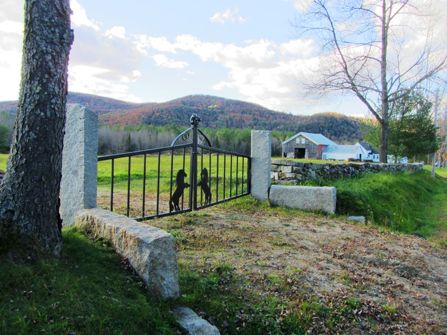
Further south on the Ridge and Valley roads, the rolling rural landscape reveals mountain views, farms and forests.
 N44° 30' 22.18\" W70° 27' 34.83\"")
Apparent Horse Cemetery on the Ridge Road (2013) @
 N44° 29' 47.36\" W70° 26' 12.12\"")
Cows near the Valley Road (2013) @
 N44° 31' 17.10\" W70° 27' 11.60\"")
Dirigo Elementary off Auburn Road (2013) [Route 108] @
Taking advantage of the abundant forest resources, the town supported five lumber mills in the late 19 century.
Government: Town Meeting-Select Board.
More Videos!
Additional resources
Turner, Hollis. The History of Peru in the County of Oxford and State of Maine from 1789 to 1911: residents and genealogies of their families … also a part of Franklin plan. Peru, Me. Town of Peru. 1979. [University of Maine at Farmington, Mantor Library; Maine State Library]
Vaughn, Mary Searles. A History of the Town of Peru Maine. Rumford, Me. Rumford Publishing Co. 1971.