
Location Map for Northfield
| Year | Population |
|---|---|
| 1970 | 57 |
| 1980 | 88 |
| 1990 | 99 |
| 2000 | 131 |
| 2010 | 148 |
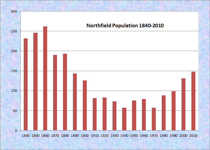
Population Trend 1840-2010
| Geographic Data | |
|---|---|
| N. Latitude | 44:49:06 |
| W. Longitude | 67:36:48 |
| Maine House | District 137 |
| Maine Senate | District 6 |
| Congress | District 2 |
| Area sq. mi. | (total) 46.0 |
| Area sq. mi. | (land) 43.7 |
| Population/sq.mi. | (land) 3.4 |
County: Washington
Total=land+water; Land=land only |
|
[NORTH-field] is a town in Washington County, settled about 1825 and incorporated on March 21, 1838 from township T24 ED. It annexed land from nearby Centerville in 1915.
According to its 2005-2008 Comprehensive Plan (condensed and edited):
Historically lakes, fields, and woods provided livelihoods for the inhabitants. They felled and sawed trees, harvested wild blueberries and raised animals and crops on the many fields, which now produce primarily blueberries. In 1860, Northfield was a large farming community producing food and cattle for the area and surrounding towns.
From around 1930 to 1950, the Town supported a sawmill, Foster’s Mill, at the head of Bog Lake to the north. They moved logs to the mill by way of horses in winter. In summer, they would push or pull them by boat. Today, that land is a small subdivision.
Blueberries are now the main crop produced in the old fields and harvested much the same way as in early times. Modern day cultivating techniques have increased the production of blueberries and other minor crops. Timber harvesting continues both privately by individuals and commercially by paper companies.
This sparsely populated, but growing community, is blessed with water resources including Bog Lake, Fulton Lake, the lower portion of Long Lake, and the winding upper reaches of the Machias River.
The main village lies on Maine Route 192 about ten miles north of Machias. A small settlement, Smith Landing, lies on the Machias River in the south of the town.
Again from the Plan:
Northfield is an entirely residential town, with no factories, stores or commercial center. Consequently, the economy is defined primarily by the sum of its citizens’ incomes: wages and salaries, or, for the self-employed, their net after expenses.
For the growing number of retirees, income is from retirement plans, interest on savings, and for some, investments. Many volunteer their time, pursue their professions, or do crafts.
Most of the labor force commutes elsewhere. For many, work is an individual effort as the seasons dictate: raking blueberries, tipping and making wreaths, or cutting pulpwood. Others work as nurses, clerks, healthcare professionals, waitpersons, or store clerks. Some work for the federal or state governments or at area schools and colleges.
Northfield, while growing, still needs a few more people to meet the 1880 population of 161, which was down from 1870’s 190 local residents. The town office is located at 1932 Northfield Road (Route 192).
")
Town of Northfield Roads and Facilities (2007)
Form of Government: Town Meeting-Select Board.
Additional resources
Varney, George J. A Gazetteer of the State of Maine. 1886. pp. 399-400.
Washington County Council of Governments. Town of Newfield. Town of Northfield, Maine Comprehensive Plan 2006. Adopted 2008. http://www.wccog.net/northfield-comprehensive-plan.htm (accessed March 30, 2014)