")
Mount Chase from Rt. 159 (2006)

Location Map for Mount Chase
| Year | Population |
|---|---|
| 1970 | 197 |
| 1980 | 233 |
| 1990 | 254 |
| 2000 | 247 |
| 2010 | 201 |
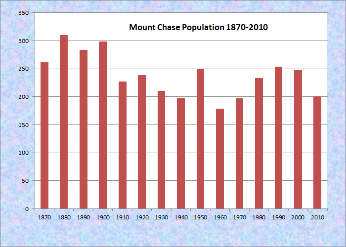
Population Trend 1870-2010
| Geographic Data | |
|---|---|
| N. Latitude | 46:05:01 |
| W. Longitude | 68:30:25 |
| Maine House | District 145 |
| Maine Senate | District 2 |
| Congress | District 2 |
| Area sq. mi. | (total) 37.4 |
| Area sq. mi. | (land) 36.3 |
| Population/sq.mi. | (land) 5.5 |
County: Penobscot
Total=land+water; Land=land only |
|
")
Sign: Site of Crommett House and Farm (2006)
") [mount CHAAS] is a town in Penobscot County, incorporated on March 21, 1864. It was reorganized as a plantation on April 6, 1936, then reincorporated at a town in 1979.
[mount CHAAS] is a town in Penobscot County, incorporated on March 21, 1864. It was reorganized as a plantation on April 6, 1936, then reincorporated at a town in 1979.
Mount Chase is the last organized town on the way to Grand Lake Matagamon and the North Entrance to Baxter State Park.
")
House facing Mt .Chase from Route 11 (2009)
Mount Chase, the mountain, rises 2,440 feet in the eastern edge of the town and dominates the horizon there. It is joined by three nearby peaks: Davis at 1,920 feet, Long at 1,720 feet, and Bald at 1,700 feet.
Home to the village of Shin Pond, which lies between the Lower and Upper Shin Ponds, the town is served by Maine Route 159, the Shin Pond Road, traveling northwest from Patten. The charm of the area has attracted both vacationers and artists.
")
Shin Pond Village Camping & Recreation Business (2006)
")
Shin Pond and Village (2006)
Carl Sprinchorn, a Swedish-born landscape painter who combined modernism and realism, spent much of his life in New York state but is most associated with Maine. Between 1937 and 1952, he lived near Shin Pond painting the life of Maine lumberjacks, hunters, and river drivers. He was a contemporary and friend of Maine artist Marsden Hartley.
")
Woods Road (2006)
Its population in 2000 was about the same as it was in 1860 when lumbering was king in the area. Mount Chase remains heavily forested with many private roads through the woods supporting logging operations.
The Crommett House and Farm was a major hub of activity in the early 20th century. Now all that remains is a sign designating its original location, in T6 R6, just north of Mount Chase.
According to a hand-painted message on a large barn in a photograph owned by the Patten Lumberman’s Museum, it claimed “The largest cold storage plant on the pike at the Crommit House, Shin Pond, Me.”
")
Gardner Point Road (2014)
 N46° 3' 17.46\" W68° 26' 30.36\"")
On Route 11 in Mount Chase (2014) @
The two large ponds attract vacationers and vacation houses and camps. Gardner Point Road, off Route 159, leads to the south shore of Upper Shin Pond, the north end of which is in T6 R6 WELS. A 1969 report counted 544 acres of surface and a maximum depth of 65 feet. The report noted, in part,
[The] Pond should be managed for the salmon and brook trout fisheries. Water quality above the 45-foot level are suitable for cold water fishes.
Excellent stream spawning and nursery areas for brook trout are available in two inlet tributaries. The thoroughfare to Lower Shin Pond is utilized by spawning salmon.
Lower Shin Pond is similar in surface area (560 acres) but its maximum depth was 25 feet in 1969. In spite of marginal water conditions, managing for salmon and trout was recommended. Upstream migration to the pond is blocked by Shin Falls on the outlet stream in T6 R6 WELS.
")
Mount Chase Town Office (2006)
 N46° 4' 38.21\" W68° 32' 30.72\"")
Volunteer Fire Department (2014) @
The International Appalachian Trail follows Route 11, the Aroostook Scenic Highway, south from Hersey. This sign below signals hikers to turn right through Mount Chase onto the Owlsboro Road.
 N46° 4' 31.62\" W68° 26' 7.92\"")
 N46° 3' 56.97\" W68° 26' 18.83\"")
Form of Government: Town Meeting-Select Board-Administrative Assistant.
Additional resources
Chadbourne, Ava Harriet. Maine Place Names and The Peopling of its Towns.
Carl Sprinchorn (1887-1971). Ask Art. The American Artists Bluebook. http://www.askart.com/AskART/artist.aspx?artist=24068&redir (accessed July 3, 2006).
Guide to the Carl Sprinchorn Papers. Fogler Library, Special Collections. University of Maine. Orono, Me. http://www.library.umaine.edu/speccoll/FindingAids/Sprinchorn.htm (accessed July 3, 2006)
Jones, Vaughan, 1881-1967, collector. Photographs of Logging Operations in Northern Maine. 1907-1928. (Cataloger Note: Album containing photographs by an unidentified photographer of logging operations in various places in Maine. Images show logging roads and camps, Lombard log haulers, skidways, a tramway at Chamberlain Lake, Shin Pond, and Telos and Webster Dams. Also depicted are railroad stations, Mt. Katahdin, St. Croix Stream and views of the Eastern Manufacturing Company in South Brewer, Maine.) [University of Maine, Raymond H. Fogler Library, Special Collections]
Maine. Department of Inland Fisheries and Game. “Upper Shin Pond.” Augusta, Me. 1969. http://www.maine.gov/ifw/fishing/lakesurvey_maps/penobscot/shin_pond_upper.pdf (accessed September 3, 2014)
Maine. Department of Inland Fisheries and Game. “Upper Shin Pond.” Augusta, Me. 1969. http://www.maine.gov/ifw/fishing/lakesurvey_maps/penobscot/shin_pond_lower.pdf (accessed September 3, 2014)
Smith, Edmund Ware. Shin Pond, Maine. Drawings and paintings by F. Wenderoth Saunders and Molly Eipper. Dearborn, Mich. Ford Motor Company. 1948. [Maine State Library]