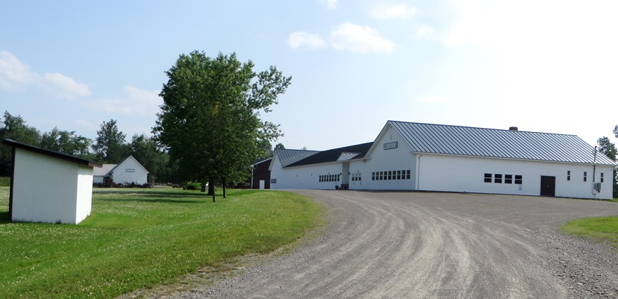
 Southern Aroostook Agricultural Museum in Littleton (2015)

Location Map for Littleton
| Year | Population |
|---|---|
| 1970 | 958 |
| 1980 | 1,009 |
| 1990 | 956 |
| 2000 | 965 |
| 2010 | 1,068 |
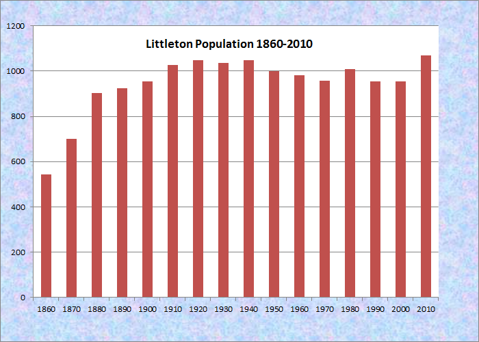
Population Trend 1860-2010
| Geographic Data | |
|---|---|
| N. Latitude | 46:13:53 |
| W. Longitude | 67:50:38 |
| Maine House | District 145 |
| Maine Senate | District 2 |
| Congress | District 2 |
| Area sq. mi. | (total) 38.6 |
| Area sq. mi. | (land) 38.4 |
| Population/sq.mi. | (land) 27.8 |
| County: Aroostook
Total=land+water; Land=land only |
|
") [LIT-ehl-tun] is a town in Aroostook County, incorporated on March 18, 1856 from half each of the Williams College (1800) and Framingham Academy (1801) grants.
[LIT-ehl-tun] is a town in Aroostook County, incorporated on March 18, 1856 from half each of the Williams College (1800) and Framingham Academy (1801) grants.
")
Potato House on U.S. Rt 1 (2003)
The first settler, Thomas Osborne, was one of the conductors of the four- and six-horse freight teams that ran from Aroostook County to Bangor.
Located in potato country just north of Houlton, Littleton is split by U.S. Route 1 and borders Canada on its east.
")
Plaque: Historic Civil Engineering Landmark (2003)
It is home to the Southern Aroostook Agricultural Museum, established in 2002, located in the former Littleton Consolidated School on U.S. Route 1.
Watson Settlement Bridge, built in 1911, was the oldest surviving example of a Howe Truss system used in a Maine covered bridge. On July 19th 2021 the historic bridge was destroyed by fire.
") |
") |
")
")
")
Watson Settlement Covered Bridge (2003)
The Littleton Esker may be seen to the west of U.S. Route 1 just north of the Littleton-Houtlon town line. Eskers are the ridges of gravel and sand that mark the routes of streams and rivers that flowed on, in, and beneath the glaciers. When the surrounding ice melted, these ridges of coarse gravel, silt, and clay remained.
 N46° 15' 38.35\" W67° 50' 26.68\"")
Maine Solar System Model – Neptune (2015) @
The University of Maine at Presque Isle’s “Maine Solar System Model” has placed planets at scale intervals on U.S. Route 1. Littleton hosts Neptune in a small park on the left side.
Not far from Neptune is the Southern Aroostook Agricultural Museum, occupying the former Littleton Elementary School. The interior of the school building contains rooms full of material representing the agricultural history of the area. Outside farm related vehicles and equipment are on display.
")
Southern Aroostook Agricultural Museum (2015)
 N46° 14' 21.12\" W67° 50' 35.52\"")
1872 Ross School at the Museum (2015) @
")
Former Littleton Elementary School (2015)
 N46° 14' 24.84\" W67° 50' 32.64\"")
Museum Exhibits (2015) @
 N46° 14' 21.24\" N46° 14' 21.24\"")
Museum Exhibits (2015) @
Form of Government: Town Meeting-Select Board-Manager.
Additional resources
Hay, Eldon. Cross-border Covenanter Communities: Richmond (NB), Houlton and Littleton (Me.) Beaver Falls, PA Semper Refomanda. c2001.
Hay, Eldon. The Covenanters of Littleton/Houlton. Sackville, N.B. The Author. 1996. (Sackville, NB. Mount Allison University)
Littleton Centennial, 1856-1956: August 15, 1956. Littleton Centennial Committee. Littleton, Me. The Committee. 1956.
Littleton Consolidated Schools. Littleton, Me. 1992? Includes: Country schools of Littleton – 1928-1936. Dorothy Shaw Campbell. 1992.
North Dakota Geological Survey. “Eskers in North Dakota.” See this for an explanation, definition, and examples of eskers. https://www.dmr.nd.gov/ndgs/ndnotes/Eskers/Eskers.asp (accessed January 10,2010)
National Register of Historic Places – Listings
Watson Settlement Bridge
[2 miles Southeast of Littleton over Meduxnekeag River] This 1911 wooden covered bridge spans the Meduxnekeag Stream five miles north of Houlton, off U.S. Route 1 on a side road two miles to the east. The Meduxnekeag Stream at this point normally is about 140′ feet wide, slow moving, flowing north and soon to flow east to enter the Saint John River in New Brunswick. This wooden covered bridge is 150′ long, 20′ wide and 20′ high from the flooring to the peak of its gable roof.
After the first settler Thomas Osborne arrived in 1835, Lewis DeLaite came in 1840, followed in the same year by Samuel Adams, Francis Watson and John Little. These three carved out farms on the east side of the Meduxnekeag and the settlement that grew in Eastern Littleton came to be known as Watson’s Settlement. The town was named Littleton in honor of Josiah Little of Portland, an earlier proprietor for the sale of the lands.
Search destroyed for other lost historic structures.
My mothers maiden name was Watson. We lived in Michigan and I am curious about this bridge and how it was named Watson.. I will be visiting Maine in the fall and would like some history regarding the bridge. Thank you.