")
Stinchfield Beach on Androscoggin Lake (2006)

Location Map for Leeds
| Year | Population |
|---|---|
| 1970 | 1,031 |
| 1980 | 1,463 |
| 1990 | 1,669 |
| 2000 | 2,001 |
| 2010 | 2,326 |
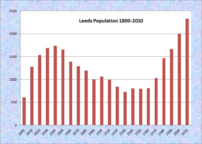
Population Trend 1800-2010
| Geographic Data | |
|---|---|
| N. Latitude | 44:17:30 |
| W. Longitude | 70:08:01 |
| Maine House | District 75 |
| Maine Senate | District 22 |
| Congress | District 2 |
| Area sq. mi. | (total) 43.4 |
| Area sq. mi. | (land) 40.3 |
| Population/sq.mi. | (land) 57.7 |
County: Androscoggin
Total=land+water; Land=land only |
|
")
Leeds Community Church (2006), curvature due to camera lens, not the church!
")
Veterans Memorial (2006)
") [LEEDZ] is a town in Androscoggin County, settled in 1779 and incorporated on February 16, 1801 from Littleborough Plantation. The following year it annexed land from Livermore, then set off land to Wayne (1810 and 1859) and to Wales (1855). It is named for Leeds, England, the birthplace of John Stinchfield, the father of the original settlers, Thomas and Roger Stinchfield.
[LEEDZ] is a town in Androscoggin County, settled in 1779 and incorporated on February 16, 1801 from Littleborough Plantation. The following year it annexed land from Livermore, then set off land to Wayne (1810 and 1859) and to Wales (1855). It is named for Leeds, England, the birthplace of John Stinchfield, the father of the original settlers, Thomas and Roger Stinchfield.
Native Americans had found the area a favorable place for their encampments. John Stinchfield noted,
No place in the Algonkin country afforded better facilities for Indian life than the banks of the Androscoggin River in Leeds and the shores of its tributary waters of the “Thirty-Mile River” ( the name early given to the chain of lakes and ponds extending from the mouth of the Dead River to the water-shed of the Sandy River).
")
The Dead River in Leeds (’06)
")
Road and Railroad Bridges over the Dead River (2006)
According to Stinchfield, Thomas Stinchfield met the native chief Sabattus when Roger was a young man, and both became close friends. “Father Thomas,” as he became known, became the arbiter of disputes among the local Native Americans. Sabattus gave Thomas fertile land once settled by a local clan, and in 1779 Thomas and his brother Roger brought provisions up the Androscoggin, planted a crop, and built a log house. It was the first permanent structure in what is now Leeds.
")
Municipal Office on Community Drive (2006)
")
Leeds Historical Society (’06)
The Leeds Historical Society occupies the old town office.
In 1801 it became the birthplace of U.S. Representative John Otis.
By 1852 four churches were established and the Androscoggin Railroad Company extended its line to the town. The Leeds and Farmington Railroad was a constituent line of the Consolidated Maine Central Railroad in 1881. In 1910 telephones came to Leeds, though electricity had to wait for Central Maine Power Company to bring the lines in 1933.
")
Stinchfield Beach on Androscoggin Lake
The east shore of Androscoggin Lake brings several miles of shore frontage to the community in the northeast corner, including Stinchfield Beach. The Androscoggin River forms the western boundary of the town, separating Leeds from Turner.
")
Leeds Central School (2006)
Local school districts were abolished in 1893, giving control of Leeds schools to a three-member board. In 1918 the State mandated a Leeds-Greene-Turner School Union.
Maine School Administrative District 52 was established in 1966 and Leavitt High School was organized. Leeds Central School is one of the schools in the district.
 N44° 20' 31.10\" W70° 11' 17.64\"")
Main Channel of the Androscoggin River from Googin’s Island (2013) @
 N44° 20' 30.65\" W70° 11' 14.48\"")
Canoe Portage on a Path to a Narrow Channel of the Androscoggin River (2013) @
 N44° 20' 31.44\" W70° 11' 15.62\"")
Island Cemetery on Googin’s Island
(2013) @
 (2013) N44° 20' 36.30\" W70° 10' 57.26\"")
Twin Bridge Market on the Howes Corner Road (Route 219) (2013) @
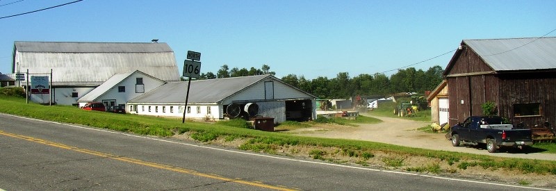
Buckley Farms, Inc. on Route 106 in Leeds (2006)
While not as important to the local economy as it was in the 19th Century, farming still thrives in some areas of the community. Amid the farms of rural Leeds, the DeCoster mill, on a railroad line in North Leeds, dominates the landscape.
")
Farm in North Leeds (2006)
")
Decoster Feeds Plant (2006)
Oliver Otis Howard was a Civil War General and Congressional Medal of Honor recipient born in Leeds, who founded the predominantly black Howard University in Washington, D. C. after the war.
")
Railroad Crossing at Curtis Corner (2006)
Former Governor Kenneth M. Curtis was born at Curtis Corner in 1931 .
Form of Government: Town Meeting-Select Board-Administrative Assistant.
Additional resources
Leeds, Maine Bicentennial, 1801-2001. 2001. [University of Maine, Raymond H. Fogler Library, Special Collections; Maine State Library]
Lynn, Elizabeth Mitchell. Taken from the Ground: Leeds, Maine in the Twentieth Century. Carmel, Indiana. Full Court Press. 1987.
Mitchell, H. E. (Harry Edward). The Town Register: Wayne, Wales, Monmouth, Leeds, Greene, 1905. Brunswick, Me. H. E. Mitchell. 1905.
Stinchfield, J. C. (John Clark). History of the Town of Leeds, Androscoggin County Maine: from its Settlement June 10, 1780. Bowie, Md. Heritage Books. 1996
National Register of Historic Places – Listings
Cape Site, Address Restricted West Leeds