

Location Map for Lebanon
| Year | Population |
|---|---|
| 1970 | 1,983 |
| 1980 | 3,234 |
| 1990 | 4,263 |
| 2000 | 5,083 |
| 2010 | 6,031 |
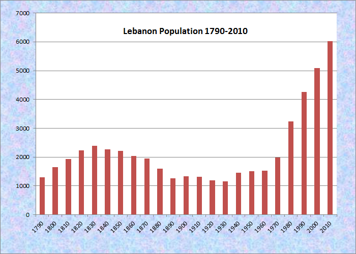
Population Trend 1790-2010
| Geographic Data | |
|---|---|
| N. Latitude | 43:06:04 |
| W. Longitude | 70:54:35 |
| Maine House | District 20 |
| Maine Senate | District 34 |
| Congress | District 1 |
| Area sq. mi. | (total) 55.8 |
| Area sq. mi. | (land) 54.7 |
| Population/sqmi | (land) 110.3 |
County: York
Total=land+water; Land=land only |
|
") [LEHB-uh-nun] is a town in York County, settled in 1743 and was known as “Towow” or “Towwoh.” It was incorporated on June 17, 1767 from Lebanon Plantation as Maine’s twenty-third town. A meeting house was erected in 1753, two garrison houses were built in 1755, and a parsonage in 1759.
[LEHB-uh-nun] is a town in York County, settled in 1743 and was known as “Towow” or “Towwoh.” It was incorporated on June 17, 1767 from Lebanon Plantation as Maine’s twenty-third town. A meeting house was erected in 1753, two garrison houses were built in 1755, and a parsonage in 1759.
 N43° 24' 16.10\" W70° 54' 27.37\"")
Municipal Offices (2014)
")
Elementary School (2014)
Lebanon annexed unincorporated land in 1785 and some from Sanford in 1787. Later it swapped land with Shapleigh, giving some in 1793 and annexing some in 1825.
The village of Center Lebanon (N43° 24′ 52.46″ W70° 55′ 3.98″) is the site of several early buildings in the town’s history. They include the 1765 First Parish Congregational Church and the old town hall. Directional signs on the town hall point to destinations on the Heath, Jim Grant, and Center roads.
")
Congregational Church (2014)
")
Congregational Church (2014)
")
Old Lebanon Town Hall (2014)
")
Signs on the Town Hall (2014)
Gazetteer of the State of Maine in 1881 included this anecdote:
The chief natural curiosity of the town is “Gully Oven,” situated in a deep ravine. It is on the road from West Lebanon Village to Acton, and one and one-half miles northerly of the former. Six miles south of the cavern, during the old French war, the Indians captured a boy of eleven years of age named Phillip Door; and they spent the succeeding night in the Oven. He was detained many years, but finally returned and became one of the first settlers of Lebanon. He said that he was captured by the Indians in the forenoon as he sat astride of a fence singing a popular song of the period, –
“As sure as eggs are bacon,
I’ll go to Canada and wont return,
Till Canada is taken,”
— which came true, sure enough.
– – – – –
The Gazetteer also notes, “During the war of the Rebellion, Lebanon furnished what would be equal to 121 three-years men for the army. Besides these, many young men, residents of the town, at the first breaking out of the war enlisted in New Hampshire regiments, for which the town never received credit from the authorities.” The Civil War Memorial is near Center Lebanon; World War II and Korea veterans are honored on the old town hall.
 N43° 24' 17.36\" W70° 54' 26.89\"")
Dead River South Branch (2017)
")
World War II & Korean War Memorial (2014)
North Lebanon village has its own historic site: the Second Baptist Church, 1777 burial ground for early settlers, and a 19th century schoolhouse.
")
Second Baptist Church (2014)
")
Schoolhouse Ice Cream (’14)
")
“Ancient Burial Ground” (2014)
Lebanon is the birthplace in 1851 of U.S. Congress member, Maine legislator, and Maine Attorney General, Charles Edgar Littlefield.
 N43° 26' 11.50\" W70° 53' 9.71\"")
Barn & Farmhouse (2014) @
 N43° 24' 43.09\" W70° 52' 4.49\"")
Lebanon Post Office (2014) @
 N43° 25' 1.19\" W70° 52' 27.97\"")
Lebanon Fire Dept. (2014) @
This western-most town borders New Hampshire on the Salmon Falls River. A rapidly growing rural commuter community, Lebanon tripled its population between 1970 and 2010, adding 20% between 2000 and 2010.
Form of Government: Town Meeting-Select Board.
Additional resources
Chamberlain, George Walter. The Beginnings of Lebanon, Maine. West Lebanon, Me. G.W. Chamberlain. 1936.
Chamberlain, George Walter. Soldiers of the American Revolution, of Lebanon, Maine. Weymouth, Mass. Weymouth and Braintree Publishing Co. 1897.
Jones, Samuel Wingate. A History of the Town of Lebanon, Maine: with a short biographical sketch of some of its first settlers. Lebanon, Me. Lebanon Historical Society, 1992.
*Maine. Historic Preservation Commission. Augusta, Me. Text and photos from National Register of Historic Places: http://pdfhost.focus.nps.gov/docs/nrhp/text/xxxxxxxx.PDF and http://pdfhost.focus.nps.gov/docs/nrhp/photos/xxxxxxxx.PDF
“Old Grist Mill.” https://www.facebook.com/pages/biz/topic_landmark/Old-Grist-Mill/1687662478121931/ (accessed June 2, 2018)
Maine. Department of Transportation. “Grist Mill Bridge, East Lebanon, Maine.”
http://www.maine.gov/mdot/historicbridges/otherbridges/gristmillbridge/index.shtml (accessed June 2, 2018)
Pray, Alicia. Where to Find Records of Lebanon, Maine: the new town lately granted by the General Court at the Head of Berwick, on the easterly side of Salmon Falls River. Lebanon, Me.? A. Pray. 1985.
Sinnett, Charles N. Historic Lebanon: Lebanon, Maine, and the grand work of its Congregational Church in one hundred and thirty-eight years. Haverhill, Mass. C.C. Morse & Son. 1903.
Varney, George J. A Gazetteer of the State of Maine. 1886. pp. 312-313.
National Register of Historic Places – Listings
Grist Mill Bridge
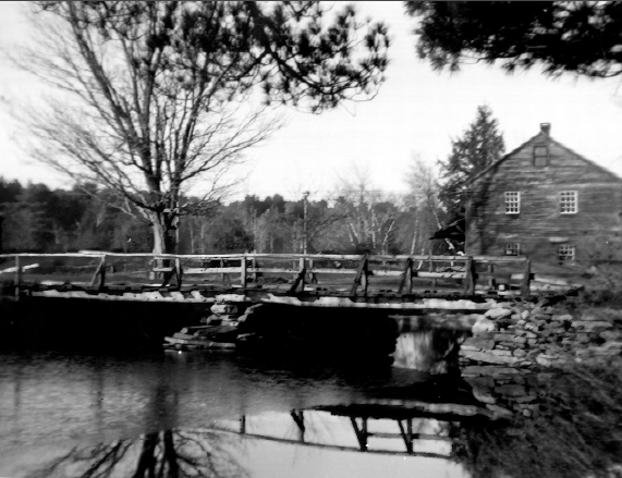
Grist Mill Bridge and Mill (1948)
[Little River Road across the Little River] The Grist Mill Bridge is about 3 miles south of East Lebanon on the Little River Road. The Bridge is a stone and timber structure just east of the 1774 Old Grist Mill. It is composed of laid rubblestone rising approximately thirteen feet above normal stream water levels.
By the late 20th century many bridges have been altered, destroyed, or replaced. This record makes the survival of a structure such as the Grist Mill Bridge very significant. Not only have the rubblestone elements remained intact, but the wooden deck is clearly in keeping with traditional materials and configuration.
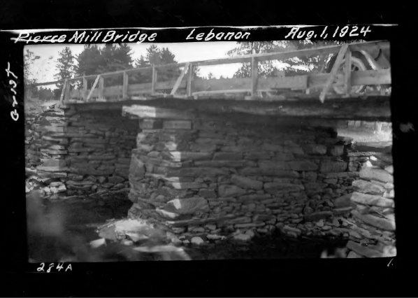
Grist Mill Bridge (1924)
Early records show, both in drawings and photos, that the bridge has changed little at least during the past 66 years. The precise history of this structure, as noted above, is difficult to ascertain. In 1792 reference is made to Joseph Hardison’s Bridge in town records. Hardison was the original owner of the adjacent grist mill built about 1774. The reference to a bridge makes it clear that the site was probably used as a crossing by then. There is, however, no proof that the bridge of 1792 (or the one referenced in an 1822 deed) is the current one.
The earliest photographic evidence is from the 1924 State survey of bridges which clearly shows the existing stonework. A review of town reports uncovered no reference to any major work on the structure outside of a deck replacement in 1885. The mill and its remnant dam are located some 100 feet to the west of the bridge at a somewhat lower elevation. Both structures (bridge and dam) and the mill foundation share the same type of rubble stone construction with wooden upper portions. This compatibility in materials is matched by an equally important historic relationship in scale. The resultant visual qualities of the site, viewed from both bridge approaches or from above or below the structure, are truly unique.
")
Grist Mill Bridge (1989)
The existing configuration of the bridge dates from the early 1950’s, when the present design replaced a simpler structure using round logs for stringers, a plank deck, and guardrails of triangular supports linked by a wooden rail. In 1993, a major renovation replaced the timber superstructure in-kind and restored the stone pier and abutments.* [Kirk F. Mohney photos, 1989]
Old Grist Mill
")
Old Grist Mill (1974)
[Little River Road East Lebanon] Built in 1774 by Joseph Hardison, this picturesque structure is the oldest industrial building in Lebanon. Its unusually good state of preservation makes it a living example of 18th and 19th century rural industry. Though built as a grist mill, later additions in its long history made it a multi-purpose establishment. In addition to its function as a flour mill, a shingle and clapboard mill, and a general woodworking mill were housed in the same structure until about 1975. Since then the building has been converted into a residence and retail/artist space, operating as such in 2018.
The mill served the town of Lebanon in several ways over the past two centuries. In the wake of the Freshet of 1785 that destroyed all the mills and bridges along the nearby Salmon Falls River, this grist mill on Little River Falls survived and continued to grind grain for the local people until the other mills could be rebuilt. The mill ground locally produced grains until the coming of the railroad about 1870 when grain from the Midwest began to be processed. Besides flour for human consumption, courser meal and blends were produced for livestock. The mill building contained a small store that served informally as a village center and public meeting place. Copies of all public notices were hung there. It was also the site of Lebanon’s first gasoline pump.* [John David Mulford photo]
West Lebanon Historic District
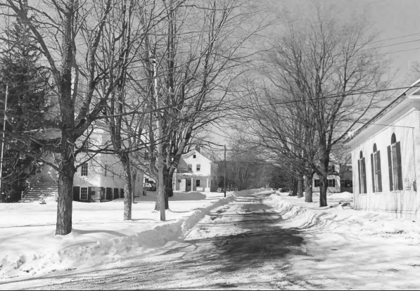
West Lebanon Historic District (1975)
[irregular pattern along West Lebanon, Rochester, Milton, Shapleigh and Meeting House Roads] Since the first quarter of the 19th Century, West Lebanon Village has undergone little physical change. Although its agricultural basis has disappeared and with it the general store and tavern, its character remains the same. It is this character which is recognized and appreciated by visitors as well as residents. The “comfortable circumstances” of the now-residential village remain—a viable testimony to the 19th Century rural community. West Lebanon retains most of the essential features of its 18th and 19th century heritage and is virtually untouched by any modern intrusions. Its architecture and conformation form a pleasing, balanced and cohesive whole.
In 1872, Lebanon was described as follows: “. . . there are but few towns in the county where the farmhouses and the mechanic’s residences are superior, either in beauty or durability and convenience. There are few towns where there is so much equality of condition among the inhabitants — there are none very poor nor rich; but nearly all in comfortable circumstances.” During the next 100 years (to the date of the National Register nomination in 1974), the Village of West Lebanon survived nearly unaltered. No commercial structures disturb its serenity and with the exception of one house built in 1915, no new homes have been built.
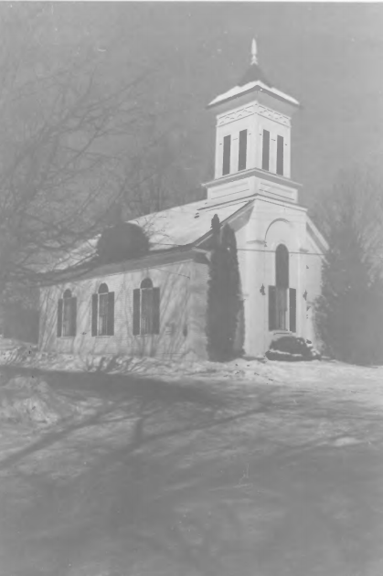
Free Will Baptist Church (1975)
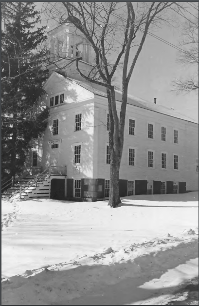
West Lebanon Academy (1975)
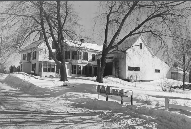
Farmhouse and Barn (1975)
The Village’s individual houses along with its Academy and its Church have retained their “beauty, durability and convenience.” Collectively, they have a sedate, rural character. West Lebanon Village, first known, as “Legro’s Corner” traces its growth to the expansion of the first designated settlement in Lebanon township. Lebanon was created in 1733 when the General Court of Massachusetts passed a resolve to open four townships, each limited to six miles square, in the Province of Maine.
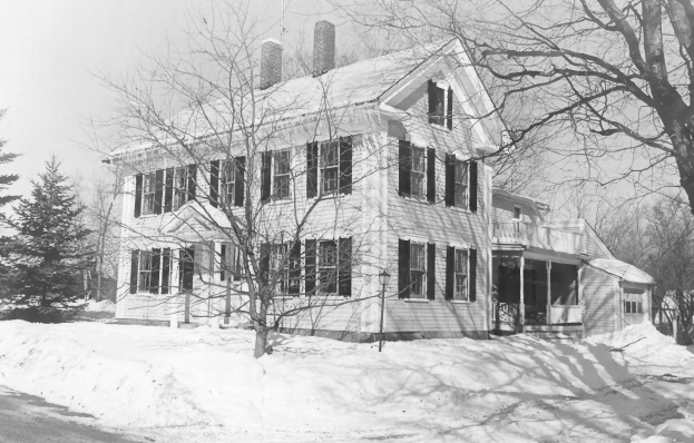
House in the District (1975)
Because of the frequent Indian wars, the General Court required all new towns to be laid out in a “compact and defensible” manner. The original 63 ”home-lots”, varying from 20 to 35 acres were surveyed and laid out by William Pepperrell along a new highway extending northeast from the Berwick line a distance of three miles. In addition to making actual settlement, the proprietors were also required to build a meeting house and settle a learned Orthodox or Protestant minister and to provide for his support and for support of schools. Few of the original proprietors actually settled in the town granted them, their places being taken by their heirs or grantees.* [Earle G. Shettleworth, Jr. photos]
Does the house in West Lebanon, Maine, that functioned in 1937-41 as a parsonage for the Free Will Baptist Church still there? Is it a parsonage still or a private home? My family lived there at that time.