 N44° 28' 44.07\" W68° 20' 28.11\"")
Lamoine Consolidated School (2013) @

Location Map for Lamoine
| Year | Population |
|---|---|
| 1970 | 615 |
| 1980 | 953 |
| 1990 | 1,311 |
| 2000 | 1,495 |
| 2010 | 1,602 |
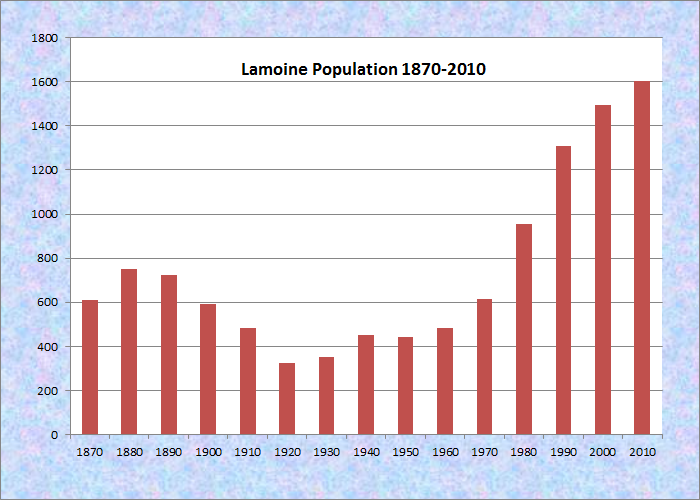
Population Trend 1870-2010
| Geographic Data | |
|---|---|
| N. Latitude | 44:29:22 |
| W. Longitude | 68:18:35 |
| Maine House | District 135 |
| Maine Senate | District 7 |
| Congress | District 2 |
| Area sq. mi. | (total) 25.1 |
| Area sq. mi. | (land) 17.9 |
| Population/sq.mi. | (land) 89.5 |
County: Hancock
Total=land+water; Land=land only |
|
") [Lah-MOYN] is a town in Hancock County, incorporated on February 11, 1870 from a portion of the town of Trenton. In 1929 it exchanged some land with the town of Hancock.
[Lah-MOYN] is a town in Hancock County, incorporated on February 11, 1870 from a portion of the town of Trenton. In 1929 it exchanged some land with the town of Hancock.
The first permanent white settler was Captain Isaac Gilpatrick who arrived with his family in 1774 from Biddeford.
A later, brief settlement by a colony of French included one De Lamoine, who owned a large tract of land west of the Skilling’s River.
 N44° 30' 7.00\" W68° 20' 51.29\"")
Lamoine Town Hall (2013) @
 N44° 28' 44.00\" W68° 20' 28.68\"")
Fire Department (2013) @
In the 1880’s, the Gazetteer of Maine had these observations:
The inhabitants are chiefly devoted to coasting and fishing. The yearly catch by vessels from this town at the Grand Banks is stated at 8,000 quintals; of Magdalen herring, 100,000 boxes; the aggregate market value of both being $55,000. . . .
Along the seashore of this town occur extensive deposits of clam shells, in which human bones have been found. In one of these beds, a few years since, Capt. A. G. Berry found a brass kettle, an axe, and a stone file.
")
Lamoine Grange (2003)
Mount Desert Narrows separates Mount Desert Island from Trenton and Lamoine. Eastern Bay is the water body east of the narrows between Lamoine and Mount Desert Island.
Lamoine State Park and Lamoine Beach are both on the shore of Eastern Bay. They are at the end of Maine Route 184, which departs from U.S. Route 1 in Ellsworth.
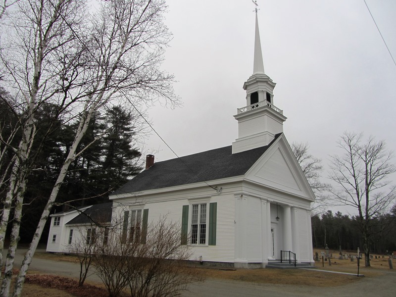
The old 1832 First Baptist Church building (see below) is a small frame structure. The current Lamoine Baptist Church is much more substantial.
 N44° 28' 42.66\" W68° 20' 38.10\"")
Lamoine Baptist Church (2013) @
Lamoine Baptist Church (2013) @
In 1902 a U.S. Navy coaling station was completed at the current State Park site. But oil was soon replacing coal, so during World War I, the station was used for the storage of nitrates, used in making explosives. After the war much of the station was dismantled.
In the 1930’s the University of Maine acquired some of the buildings for a biological laboratory. It became a State Park in the 1950’s.
 N44° 30' 3.40\" W68° 20' 48.99\"")
Convenience Store in Lamoine (2013) @
 N44° 30' 7.82\" W68° 20' 51.02\"")
Lamoine Veterans Memorial (2013) @
This growing fishing, vacation, and retirement community has fine views of Frenchman’s Bay and Mount Desert Island.
")
October Sunset at Lamoine Beach (2003)
Form of Government: Town Meeting-Select Board-Administrative Assistant.
Additional resources
A Souvenir of Old Lamoine. Lamoine, Me. Lamoine Historical Society, 19–?. (pictorial – copy at Maine State Library)
Cooper, Josephine. “A Short History of Lamoine.” http://www.lamoine-me.gov/History.htm (accessed April 11, 2013)
Douglas, John Sherman. The First Baptist Church, Lamoine, Maine. Lamoine, Me.? J.S. Douglas?. 1932.
Lamoine, Maine: 1870-1995, 125th Birthday Celebration. Ellsworth, Me. N.K. Sawyer. 1995.
Lawton Register Company. Town Register: Trenton, Lamoine, Hancock, Sullivan, Sorrento, Gouldsboro, Winter Harbor. Auburn, Me. Lawton Register Co. 1911.
*Maine. Historic Preservation Commission. Augusta, Me. National Register source files have changed! 2016 UPDATE: Follow the link above to find sources for these properties using their eight digit “Reference Number.“
Varney, George J. A Gazetteer of the State of Maine. 1886. pp. 310-311.
Winterbotham, John C. Lamoine and its Attractions as a Place of Summer Sojourning. Boston. Issued by Lamoine and Mount Desert Land Company. 1887. (W.H. Couillard, printer)
National Register of Historic Places – Listings
First Baptist Church
") [362 Lamoine Beach Road, Lamoine Beach] Built in 1832 and remodeled in 1879, the First Baptist Church is a wooden frame building that was designed and built by the Ellsworth architect/builder Seth J. Tisdale. The Church traces its origins to the first decade of the 19th century when eight congregants were gathered by Elder Jason Livermore. Revivals increased the membership so that by April of 1832 sufficient means existed to erect the present church building.
[362 Lamoine Beach Road, Lamoine Beach] Built in 1832 and remodeled in 1879, the First Baptist Church is a wooden frame building that was designed and built by the Ellsworth architect/builder Seth J. Tisdale. The Church traces its origins to the first decade of the 19th century when eight congregants were gathered by Elder Jason Livermore. Revivals increased the membership so that by April of 1832 sufficient means existed to erect the present church building.
Apparently a split developed in the congregation by the early 1840s, and in 1853 a new church building was built by the Baptists in Lamoine. Later the two congregations reunited, but the use of the original church is not entirely clear. Nonetheless, it seems to have continued to be an important part of the community’s religious life since considerable effort was made to update the building in 1879.
Eventually the building was deeded to the Cemetery Association (responsible for the cemetery behind the church). In the 1970s the Association deeded it to the Lamoine Historical Society. As originally built, the First Baptist Church was a decidedly Greek Revival style building. It once had a squat tower that featured Gothic Revival style spirelets at its four corners. In its basic form, this original building was not unlike other churches of the period including St. John’s Episcopal Church in Dresden, and its near twin, the Pittston Congregational Church.
In 1879, the congregation engaged another noted Ellsworth builder, Asa Hodgkins, to design and build a new tower. This new structure and its flanking entrance porches updated the building’s appearance in the latest architectural fashion. Thus, the present configuration relates the church to a group of Italianate style buildings erected between the 1850s and 1870s, all of which are characterized by the attached frontal tower.*
Shore Acres
") [791 Lamoine Beach Road, Lamoine Beach] Shore Acres is a basic two-story frame building that is significantly associated with the history of summer tourism in Lamoine. Originally built by members of the Des Isles family, the house was substantially remodeled and enlarged in 1887. Sometime thereafter it was named Shore Acres. However, during the 1930s the additions were removed, perhaps because of a decline in the tourist trade at the height of the Depression. The building assumed its present appearance from that time.
[791 Lamoine Beach Road, Lamoine Beach] Shore Acres is a basic two-story frame building that is significantly associated with the history of summer tourism in Lamoine. Originally built by members of the Des Isles family, the house was substantially remodeled and enlarged in 1887. Sometime thereafter it was named Shore Acres. However, during the 1930s the additions were removed, perhaps because of a decline in the tourist trade at the height of the Depression. The building assumed its present appearance from that time.
One of Lamoine’s enduring traditions of its early history relates to the aspirations of a wealthy French widow who acquired a large tract of land in the late 18th century to build a community for her ex-patriate countrymen. After a few years she abandoned the project to become the wife of a governor of one of the islands of the Spanish Main, and turned her landholdings over to her secretary Louis Du Parre Des Isles.
") In 1796 Des Isles married Mary Googins, and tradition holds that thereafter they began the construction of a residence. Local accounts of the history of Shore Acres disagree about when and why is was built. However, it became an inn named the Des Isles House. Beginning in 1879 and continuing until 1888, the annual editions of the Maine Register do list it under the proprietorship of William Des Isles. It was the only hotel in Lamoine listed in the Register at that time through 1887. The Des Isles House was substantially enlarged by William Francis Des Isles in 1887. In 1903-04 Shore Acres appears as a summer hotel under the management of Edmon Eno.* [Kirk H. Mohney photos]
In 1796 Des Isles married Mary Googins, and tradition holds that thereafter they began the construction of a residence. Local accounts of the history of Shore Acres disagree about when and why is was built. However, it became an inn named the Des Isles House. Beginning in 1879 and continuing until 1888, the annual editions of the Maine Register do list it under the proprietorship of William Des Isles. It was the only hotel in Lamoine listed in the Register at that time through 1887. The Des Isles House was substantially enlarged by William Francis Des Isles in 1887. In 1903-04 Shore Acres appears as a summer hotel under the management of Edmon Eno.* [Kirk H. Mohney photos]