
Location Map for Jonesport
| Year | Population |
|---|---|
| 1970 | 1,326 |
| 1980 | 1,512 |
| 1990 | 1,525 |
| 2000 | 1,408 |
| 2010 | 1,370 |

Population Trend 1840-2010
| Geographic Data | |
|---|---|
| N. Latitude | 44:33:17 |
| W. Longitude | 69:30:54 |
| Maine House | District 138 |
| Maine Senate | District 6 |
| Congress | District 2 |
| Area sq. mi. | (tot.) 100.7 |
| Area sq. mi. | (land) 28.5 |
| Population/sq.mi. | (land) 48.1 |
| County: Washington
Total=land+water; Land=land only |
|
 [JONES-port] is a town in Washington County, incorporated on February 3, 1832 from a portion of Jonesborough (Jonesboro). On April 7, 1925 it set off land to form the town of Beals.
The main village is located on Moosabec Reach and the Indian River.
A bridge across the Reach leads to the island community of Beals. Route 187 loops from U.S. Route 1 to West Jonesport, then to Jonesport and back to Route 1 just west of Jonesboro.
Local residents work in blueberry, fishing and boat building industries, and in tourist services during the summer.

Piers with Lobster Traps near the Jonesport-Beals Bridge
")
Wharf in Jonesport on Moosabec Reach (2004)
These photos of the Jonesport waterfront with a truck on commercial pier delivering bait or loading fish (right); and fuel on distant float and lobster traps on float in foreground are both typical of the support system for the local fishing industry.
Green crabs, an invasive species first observed in Casco Bay in 1900, reached Jonesport in 1951, threatening the soft shell clam industry.
Off Shore Islands
Southeast of the mainland in Eastern Bay Jonesport is home to a collection of islands of various sizes, Head Harbor Island and Steels Harbor Island being the largest. In 2010 the seven-acre Middle Hardwood Island, near Head Harbor Island, was for sale at $1,450,000. It claimed “all the conveniences of home” with one bedroom and two guest cottages, solar and diesel electricity and a deepwater dock.*
Most of the dozen or so remaining islands in this group have little more than 1-2 acres.
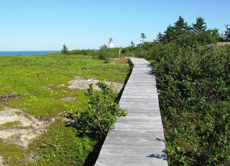
Moose Peak Light on the 30-acre Mistake Island has the distinction of serving the foggiest area on the east coast of the United States. It averages 1580 hours of heavy fog each year. Eastport has 65 days and Portland, 55 days. The lighthouse is at the eastern point of Mistake Island, east of Great Wass Island in Eastern Bay. It is also known as Mistake Island Light; Head Harbor Light; Moose-a-bec Light.
")
Moose Peak Light on Mistake Island (2011)
")
Moose Peak Light on Mistake Island (2011)
The site includes a 57 foot brick and masonry tower (1827), 18 feet in diameter, on four acres of ledge. The remainder of the island is occupied by the Nature Conservancy. The public may visit if they walk only on the boarded walkways. More photos here.
Western Brothers Island, managed jointly by The Nature Conservancy and the State Department of Inland Fisheries and Wildlife, is home to seabirds and rare plants.
Jonesport shares the Great Wass Archipelago nature preserve with the adjoining town of Beals.
A 1991 monument to the vessel Nellie Chapin Day stands at the town’s entrance to the bridge. The ship, according to the inscription, left with 157 New Englanders sailing to Jaffa, Palestine in 1866, arriving “to help restore the land of Israel.”

Jonesport from Beals Harbor
The view from Beals Island provides a spectacular picture of Jonesport’s waterftont.

Coast Guard Station Jonesport
The town hosts a U.S. Coast Guard station, headquartered at the entrance to the Jonesport-Beals Bridge. The station was established in 1967. Facilities include a two-story brick building equipped with a third story observation tower, a two-slip boathouse, and a 120-ft pier. Tenant units include the Coast Guard Cutter Moray and Maine Marine Patrol. Coast Guard Station Jonesport’s area of responsibility runs from Long Point (20 miles east of Jonesport) east to Petit Manan Island. It encompasses all navigable waters and offshore islands.

Monument to the Nellie Chapin Day expedition
Form of Government: Town Meeting-Select Board.
More Videos!
Additional resources
American History Department of Jonesport-Beals High School. A Pictorial History of the Town of Jonesport, Maine. Calais, Me. Advertiser Publishing Company. 1970.
Chamberlain, George Walter. “A New England Crusade.” The New England Magazine, Volume 36. March 1907–August 1907. pp. 201-201. http://books.google.com/books? (accessed November 26, 2012)
Jonesport: A Group of Historical Sketches Written in Honor of the Centennial. Machias, Me. Teague Publishing Co. 1932?
Limeburner, Grace M. Grindle. The Folks of Stuben [sic] Johnsboro [sic] Jonesport and Nearby Towns. North Brooksville, Me. G. Limeburner. 1951-1953?

Jonesport’s Peabody Memorial Library
Monks, John Peabody. Roque Island. 1955.
National Park Service. NATIONAL HISTORIC LIGHTHOUSE PRESERVATION ACT OF 2000
NOTICE OF AVAILABILITY JULY 9, 2010. https://www.nps.gov/maritime/nhlpa/noa/2010/MoosePeakNOAFactSheet.pdf (accessed January 28, 2017)
*Stuart, Donna. “Private Isles.” Summer Guide 2010. Portland Magazine. https://www.portlandmonthly.com/portmag/2010/06/private-isles/ (accessed July 18, 2019)
Tibbetts, Leonard F. Early Families of Jonesport, Maine. Brewer, Me. Cay-Bel Pub. 1985.
Station Jonesport Internet site at http://www.uscg.mil/d1/units/gruswh/grpunits/stajonesport.htm