
Location Map for Jackman
| Year | Population |
|---|---|
| 1970 | 848 |
| 1980 | 1,003 |
| 1990 | 920 |
| 2000 | 718 |
| 2010 | 862 |
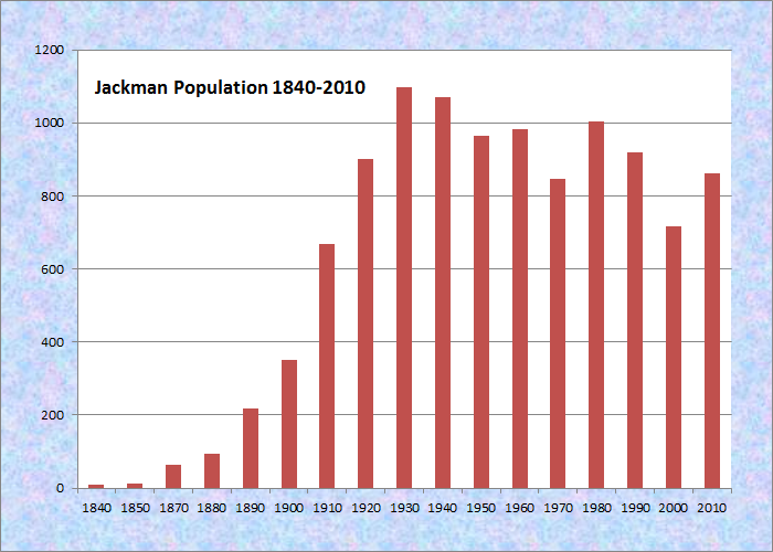
Population Trend 1840-2010
| Geographic Data | |
|---|---|
| N. Latitude | 45:36:45 |
| W. Longitude | 70:12:32 |
| Maine House | District 118 |
| Maine Senate | District 3 |
| Congress | District 2 |
| Area sq. mi. | (total) 42.2 |
| Area sq. mi. | (land) 41.1 |
| Population/sq.mi. | (land) 21.0 |
| County: Somerset
Total=land+water; Land=land only |
|
")
Moose River Congregational Church (2004)
")
St. Anthony’s Catholic Church (2004)
")
Jackman Public Library (2004)
[JAK-mn] a plantation in Somerset County, was formally organized on March 5, 1895 after earlier organization for election purposes in 1859 and 1894. The plantation emerged from the township T4 R1 NBKP.
Jackman is home to a Passamaquoddy tribe that harvests and markets maple sugar as “Passamaquoddy Maple.”
James Jackman, for whom the town was named, was usually called “Captain Jackman.” He was contracted by the State to build the Canada Road from The Forks to the Canadian border.
")
Main Street (2004)
")
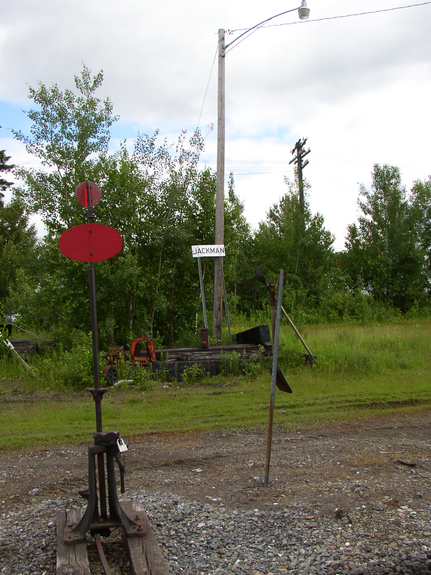
Former Railroad Station (’04)
The village is on the shore of Wood Pond in Attean Township just to the west. Attean Pond and Attean Mountain are southwest of the village in an area designated as one of Maine’s “public reserved lands.”
The area provides attractive fishing and hunting opportunities, canoe trips on the Moose River, and jobs for workers in the logging industry.
")
Attean Mountain & Lake ’04
 N45° 37' 15.22\" W70° 14' 53.17\"")
The Town Office (2004) @
On the Moose River only 15 miles from the Canadian Province of Quebec, Jackman is the gateway for people visiting Quebec City from Maine. It is also 65 miles from Skowhegan in the south and had a small population of 782 according the 2020 Census.
")
Wood Pond and Sally Mountain (2004)
")
Moose River Entering Wood Pond (2004)
The downtown reflects the tourist and outdoor recreation base of the community, with lodging and restaurant facilities.
")
Downtown Jackman on U.S. Route 201 (2014)
")
Downtown Jackman on U.S. Route 201 (2014)
")
Old Canada Road Inn Downtown (2014)
")
Ma Ma Bear’s Restaurant (2014)
The Moose River Congregational Church is in Jackman, just barely south of Moose River on the Heald Stream Road. The farm in foreground below right is on the Sandy Stream Road; the one in background is on U.S. Route 201; both in Jackman.
 N45° 37' 29.42\" W70° 15' 15.22\"")
Jackman Hotel on U.S. Route 201 (2014) @
 N45° 38' 21.60\" W70° 15' 41.60\"")
Moose River Congregational Church (2014) @
 N45° 39' 2.85\" W70° 16' 23.55\"")
Farms Near Sandy Stream (2014) @
 N45° 37' 4.31\" W70° 14' 37.43\"")
Old Schoolhouse on U.S. Route 201 in Jackman (2014) @
Form of Government: Town Meeting-Select Board-Manager.
Additional resources
Calvert, Mary R. The Kennebec Wilderness Awakens.
The History of Moose River Valley: Jackman, Moose River, Dennistown, Long Pond, Parlin Pond, Holeb, Skinner and Lowelltown. Jackman, Me. Jackman Bicentennial Book Committee. 1976.
*Maine. Historic Preservation Commission. Augusta, Me. Text condensed and edited from National Register of Historic Places: http://pdfhost.focus.nps.gov/docs/nrhp/text/xxxxxxxx.PDF
Pierce, D.C. Hotel Guest Registers, 1890-1909. (Cataloger Note: Guest registers for the Newton House, Jackman, Maine; the West Forks Hotel, West Forks, Maine; and The Forks Tavern, The Forks, Maine. D.C. Pierce was the proprietor of the hotels. The register for the Newton House has blotter sheets between pages that contain advertisements for various businesses in Jackman.) [University of Maine, Raymond H. Fogler Library, Special Collections]
Sprague, John Francis. Jackman and the Moose River Region. Dover. 1915. (Reprinted from Sprague’s journal of Maine history. v. 3, no. 2, July, 1915)
National Register of Historic Places – Listings
Moose River Congregational Church
[Junction of Maine Route 201 and Nichols Road in Jackman] Built in 1891, the Moose River Congregational Church is a late Gothic Revival frame landmark along Route 201, historically known as the Canada Road. First settled in 1820, the residents of the Moose River Valley were sporadically served by circuit preachers from a variety of denominations beginning as early as 1849. As was the case in the early years of settlement in many Maine towns, the community did not have a specific place of worship for several decades.
In 1873 Moose River Plantation built a school house in which the upper floor accommodated religious services in what was known as the Union Church. There was no resident pastor for this church where services were held only in the summer. As the population increased during the 1880s, it became apparent that a church building was necessary. In 1890, the Moose River Congregational Church was formed and the church building was ready in June of 1891.
Architecturally, this Church is part of a group of religious properties erected in Maine beginning in the mid-19th century that share the general characteristics of a steeply pitched gable end and attached centrally located entrance tower. Whether executed in the Gothic, Italianate, or Romanesque style, these buildings indicate a decided change in fashion from church architecture in which towers were typically mounted atop the roof or above a portico.* [See photos above]
Where in Jackman, Maine was the Newton House located?