
Location Map for Industry
| Year | Population |
|---|---|
| 1970 | 347 |
| 1980 | 563 |
| 1990 | 685 |
| 2000 | 790 |
| 2010 | 929 |

Population Trend 1810-2010
| Geographic Data | |
|---|---|
| N. Latitude | 44:45:40 |
| W. Longitude | 70:03:21 |
| Maine House | District 114 |
| Maine Senate | District 17 |
| Congress | District 2 |
| Area sq. mi. | (total) 31.2 |
| Area sq. mi. | (land) 30.0 |
| Population/sq.mi. | (land) 31.0 |
County: Franklin
Total=land+water; Land=land only |
|

Welcome Sign
[IN-dus-tree] is a town in Franklin County, incorporated on June 20, 1803 from Industry Plantation.
From 1813 to 1844 it annexed land from New Sharon, New Vineyard, Starks and Anson.
In 1850 and 1852 it ceded land to Farmington and New Sharon respectively.
")
Clearwater Pond at Allens Mills
")
Industry Town Hall (2005)
Settled in 1783, Industry’s main villages are Allens Mills, at the southern end of Clearwater Pond, and West Mills.
So what were the “industries” at these “mills” villages? According to the Gazetteer of Maine in 1886,
There are good water-powers at the outlet of Clear Water Pond, which are improved [that is, they have dams]. This point is known as Allen’s Mills . . . . The manufactures at Allen’s Mills, are lumber, chairs, salt-boxes, wheel-hubs and shovel handles. At West’s Mills are rakes, wheels, spade-handles, lumber, harnesses, boots and shoes, meal and flour. At the center is located the Enterprise Cheese Factory, and a boot and shoe-shop.
In 1880 the town’s population of 609 supported ten schoolhouses.
Clearwater Lake/Pond covers 796 acres. It attracts anglers, boaters and swimmers in summer and ice fishing in winter. A water supply reservoir and for flood control, the Lake’s a maximum depth is 129 feet with an average depth of 60 feet. Muddy Brook Stream is the outlet at the dam. A dam has been on the lake since at least 1860. The Town of Industry owns and manages the Dam.
Industry, a growing community, is served by Maine Routes 43 and 148 and lies just northeast of Farmington. After reaching a historic low of 262 residents in 1960, the population has rebounded to almost rival its 19th century boom levels.
")
Classic Barn (2005)
")
“Little Red Schoolhouse” (’05)
The barn and schoolhouse above reflect Industry’s historic roots.
The Goodridge Corner school, the “little red schoolhouse,” is the home of the town’s historical society.
")
Shorey Chapel in Industry (2005)
")
Store on the shore of Clearwater Pond (2005)
")
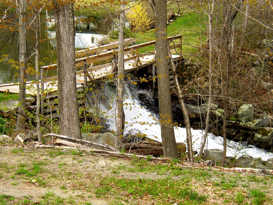
Dam at a small pond in Allens Mills (2005)
")
Buildings at a small pond in Allens Mills (2005)
Form of Government: Town Meeting-Select Board.
Additional resources
Allen, William. History of Industry, Maine: From the First Settlement in 1791. Skowhegan, Me. Smith & Emery, printers. 1869.
Hatch, William Collins. A History of Industry, Maine. Somersworth, N.H. New England History Press. 1984. [reprint of 1893 edition]
*United States. Department of the Interior. National Park Service. “Thompson’s Bridge.” https://npgallery.nps.gov/pdfhost/docs/nrhp/text/91000321.PDF (accessed March 28, 2017)
Varney, George J. A Gazetteer of the State of Maine. 1886. pp. 286-287.
National Register of Historic Places – Listings
Thompson’s Bridge
[over Thompson’s Creek off the north side of Maine Route 43 at Franklin–Somerset County line, Allen’s Mills]
Thompson’s Bridge is a short, narrow dry laid masonry structure located on a long abandoned town road at the east edge of Industry. Possibly built as early as 1808, the bridge represents a method of traditional construction once common in Maine. It is one of less than a dozen relatively unaltered historic resources in the town.
")
Thompson’s Bridge Road (1990)
")
Thompson’s Bridge (1990)
Such structures, whether wood or stone have been called “pioneer bridges.” These simple structures were built over small streams in a way that survived the stream’s flood stage, the projected maximum loads, and the intended longevity. The resulting design used locally available materials and expertise. In 1924, there were hundreds of structures similar to this bridge in Maine. Since then an equally large number have been replaced with steel or concrete bridges. In some cases the original stone abutments of the early bridges have been retained or in places reinforced, but the decks have been completely rebuilt using steel or concrete. One notable exception to this process is the Grist Mill Bridge in Lebanon in which a wooden deck is still in use over the two span dry laid stone masonry structure. [Compare the remains of a similar bridge over Grant Brook in Brighton.]
")
The old road (2018)
Town records indicate that the related road was laid out in 1808. This road passed the residence of Captain John Thompson, who apparently had a saw and grist mill in 1805.* [Kirk F. Mohney B&W photos]
Since 1990, the bridge has collapsed and the old 1808 road by 2018 has essentially disappeared.
The stones that were part of the bridge have created a small dam, creating a small pond above the site.
Access is from a public dead end dirt road, followed by a private dirt road allowing foot traffic only. Later that road became a thicket that can be navigated carefully to the old bridge site.
")
Remains of the bridge. (2018)
")
Pond above the Dam (2018)
Hi,
I’m doing historical research on Industry and the town’s early inhabitants. I’m also a property owner in Industry – lot 76 map R4.
My father grew up on that property and he attended the Red School House at Goodrich Corner, which leads to my question. I notice that the schoolhouse is listed as the location of the Industry Historical Society. Is it ever open to the public, and what kinds of records might be are kept there?