
Shore of Lake Anasagunticook on Main Street (Route 140) in Northern Hartford

Location Map for Hartford
| Year | Population |
|---|---|
| 1970 | 312 |
| 1980 | 480 |
| 1990 | 722 |
| 2000 | 963 |
| 2010 | 1,185 |
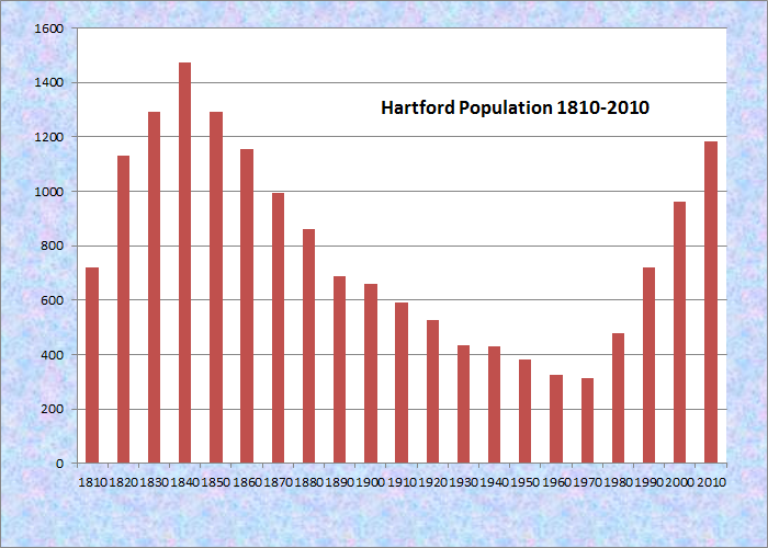
Population Trend 1810-2010
| Geographic Data | |
|---|---|
| N. Latitude | 44:22:24 |
| W. Longitude | 70:19:57 |
| Maine House | District 116 |
| Maine Senate | District 18 |
| Congress | District 2 |
| Area sq. mi. | (total) 45.1 |
| Area sq. mi. | (land) 43.9 |
| Population/sq.mi. | (land) 27.0 |
County: Oxford
Total=land+water; Land=land only |
|
 N44° 20' 13.45\" W70° 22' 27.32\"")
Nezinscot River East Branch near Sumner-Hartford Line on Butterfield/Sumner Road (Route 140) @

Pine Shores Subdivision off Church Street (2013) @
 N44° 20' 55.55\" W70° 17' 58.85\"")
“Camp Wekeela for Boys and Girls” on Route 219 (2013) @
[HART-frd] is a town in Oxford County, incorporated on June 13, 1798 from East Butterfield Plantation.
After annexing land from Plantation Number 1 (1807) and Chandler’s Gore (1834), its substantial size was diminished by land transfers to Canton (1838, 1839, 1850) and to Buckfield (1856, 1862).
 N44° 20' 34.89\" W70° 16' 11.26\"")
On Berry Road overlooking Bear Pond (2013) @
 N44° 20' 34.68\" W70° 16' 11.50\"")
Cottages, Boat Launch on Bear Pond, Berry Rd. (2013) @
Bear Pond in the south, near Route 219, is the site of seasonal camps and boating for residents and summer visitors. Part of the Pond is in nearby Turner.
The town’s name is after Hartford, Connecticut, which itself is named for Hartford, England.
 N44° 22' 27.76\" W70° 20' 50.44\"")
J&O Irish Museum (2013) @
The area was first settled by Edmund Irish in 1788, ten years before it was incorporated as a town.
In the 1880’s the town supported fourteen schoolhouses with a population of 863 in 1880.
Hartford’s historical society is located in the historic J. & O. Irish Store on Main Street.
 N44° 23' 29.47\" W70° 18' 41.27\"")
Farmhouse and Barn on Church Street (2013) @
 N44° 25' 7.23\" W70° 18' 52.87\"")
Orchard on Church Street (2013) @
Church Street, an extension of Staples Hill Road in Canton, is a rural road with farms, the old school and community church, with access to the southern shore of Lake Anasagunticook.
The small Nezinscot River (east branch) flows through the town, defining its border with Sumner, eventually entering Buckfield. From Buckfield to Turner, the river is a corridor for canoe trips, with a portage at Turner Village.
Lake Anasagunticook on Main Street (Route 140) in northern Hartford is surrounded by seasonal and year-round houses.
A private subdivision, Pine Shores, is on the southern end. The bulk of the lake is in the town of Canton, north of Hartford.
 in Northern Hartford N44° 26' 1.27\" W70° 19' 49.67\"")
Shore of Lake Anasagunticook in Hartford (2013) @
 in Northern Hartford N44° 26' 1.18\" W70° 19' 49.78\"")
Shore of Lake Anasagunticook in Hartford (2013) @
This small but growing community, having tripled its population from 1970 to 2000, then added another 23% by 2010.
Hartford is northwest of Lewiston-Auburn via Maine Routes 4 and 219. Routes 219 and 140 intersect at Hartford Center.
")
1899 Union School House on Church Street (2013)
")
Hartford Community Church, Church Street (2013)
Rock hunters have been attracted to its rich deposits of quartz and feldspar.
 at Tucker Road N44° 22' 32.74\" W70° 20' 49.89\"")
Hartford Town Office (2013) @
 in Hartford at Tucker Road N44° 22' 33.92\" W70° 20' 50.27\"")
Community Building, Veterans Memorial (’13) @
Form of Government: Town Meeting-Select Board.
Additional resources
Libby, Wilbur A. Hartford, Maine. Maine. W.A. Libby. 1985. [Maine State Library]
*Maine. Historic Preservation Commission. Augusta, Me. Text and photos from National Register of Historic Places: http://pdfhost.focus.nps.gov/docs/nrhp/text/xxxxxxxx.PDF and http://pdfhost.focus.nps.gov/docs/nrhp/photos/xxxxxxxx.PDF
McCauley, Brian. The Names of Maine: How Maine Places Got Their Names and What They Mean.
Parsons, Harold E., Mrs. A Brief History of the Town of Hartford, Maine. Hartford, Me. Town of Hartford. 1974. [Maine State Library]
Parsons, Lorraine. Town of Hartford 2000: Military Service. Hartford, Me. L. Parsons. 2000.
The town office, and the adjoining community building, are on Main Street (Route 140) at Tucker Road.
National Register of Historic Places – Listings
Photos, and edited text are from nominations to the National Register of Historic Places researched by Maine. Historic Preservation Commission.
Full text and photos are at https://npgallery.nps.gov/nrhp
Irish, J. & O., Store
[Maine Route 140] Now a museum, the J. & O. Irish Store has been virtually untouched by time since it was built in 1888 by Orlando Irish, a prosperous farmer who decided to go into commerce. The interior, totally unchanged, is a time capsule revealing the ambiance of a late 19th century general store and post office with furnished rooms on the upper floors where the Irish families lived.
In 1976 the building was given by a descendent of the original owners, James Irish, to the Hartford Heritage Society, which maintains and has improved the structure. In the barn are the collections of the Society, a variety of artifacts owned by Hartford residents.
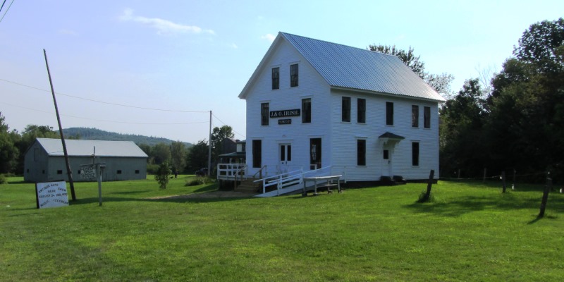
J. & O. Irish Museum (2013)
J. & O. Irish Store is a large rectangular structure with an attached barn. Both buildings are 2½ stories high with a gable roof and clapboard siding. The interiors are as unaltered as the exteriors. In the store itself there are simple wood counters and shelves, as well as a wood icebox and a desk for sorting mail. Both the store and the living quarters have original wood floors and door and window trim. None of the woodwork, however, is ornamented. To enter the Irish Store is to step back in time more than a century.*
Union School
The Union School is in the center of rural Hartford. The gable front ordinary schoolhouse with minimal Colonial Revival Style details is significant at the local for its distinctive architectural characteristics of a rural one room schoolhouse. The building represents Hartford’s response to evolving educational practices which were often mandated by state law. The school is an intermediary step between the often autonomous 19th century district system and the mid-twentieth century full consolidation of town and regional schools. The 1899 building was altered in 1923 to accommodate evolving trends in education. These alterations are significant since they occurred while the building was operating as a school, 1899-1952. Of the many one room schoolhouses built in Hartford, several are still standing. These remaining school buildings have been greatly altered for use as homes or garages. See another photo of the school above right.
Warren, David, House
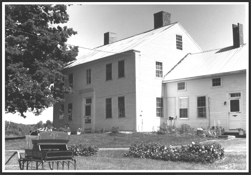
Warren Homestead (1982)
[off Maine Route 140] The David Warren Homestead is a 2½ story pitched-roofed Federal farmhouse with side ell and attached small barn. Christened Apple Hill Farm by the recent owners, the house and outbuildings sit on 113 acres. The house is the largest and most imposing in the community.
The Warren House is the only large Federal residence in the Hartford area, being unique in size and interior design. The state of preservation and restoration of the interior rivals, for authenticity, the interiors of many Maine historic buildings.
David Warren (1760-1847), a Revolutionary War soldier, was an early settler of Buckfield and had the house built shortly before 1805. Warren served eleven terms as a representative to the General Court in Boston.He was Hartford’s Justice of the Peace. The house remained in the Warren family until 1914.* [Frank A. Beard photo]