
Location Map for Glenwood
| Year | Population |
|---|---|
| 1970 | 9 |
| 1980 | 7 |
| 1990 | 8 |
| 2000 | 0 |
| 2010 | 3 |
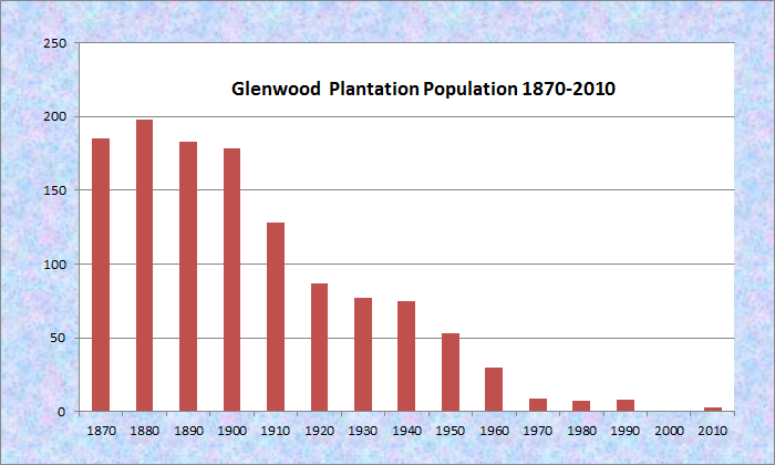
Population Trend 1870-2010
| Geographic Data | |
|---|---|
| N. Latitude | 45:48:28 |
| W. Longitude | 68:06:08 |
| Maine House | District 144 |
| Maine Senate | District 22 |
| Congress | District 2 |
| Area sq. mi. | (total) 39.5 |
| Area sq. mi. | (land) 38.2 |
| Population/sq.mi. | (land) 0.1 |
| County: Aroostook
Total=land+water; Land=land only |
|
[GLEN-wood] is a plantation in Aroostook County, incorporated as a town on February 14, 1867 from Glenwood Plantation, that was organized for election purposes in 1863.
 N45° 46' 34.06\" W68° 6' 33.02\"")
Old Schoolhouse (2017) @

Public Works Area (2017)
After only a year, it surrendered its status as a town from 1868 through early 1877.
On March 5, 1877 it became organized as a plantation.
This old schoolhouse, (above) now abandoned, was used as voting place as late as 1996, and for plantation meetings. In 2017 it was open to the elements and animals.
Glenwood contains most of Wytopitlock Lake (the balance is in T2 R4 WELS) and Orcutt Brook, which empties into it. In 2004 only a few camps were scattered along the rocky shore.
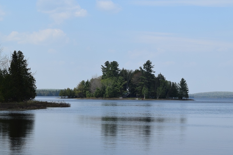
Island in Wytopitlock Lake (2017)
 N45° 46' 48.71\" W68° 9' 10.05\"")
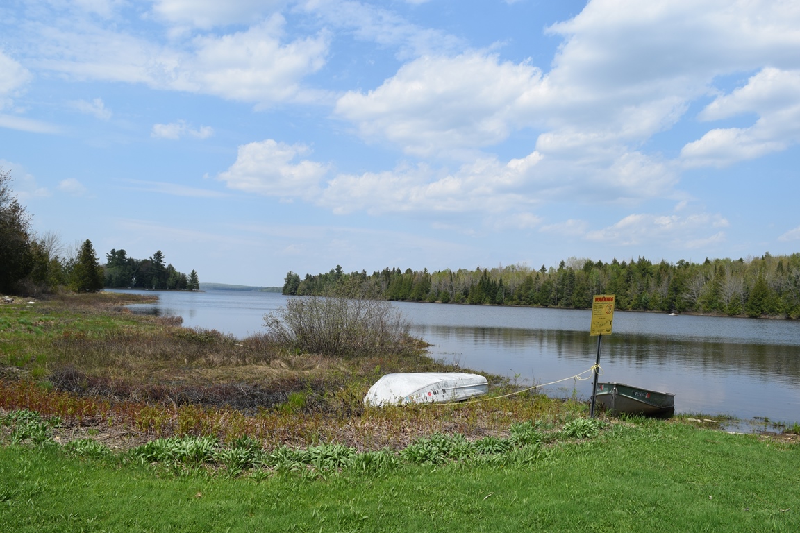
Boat Launch on the Lake (2017) @
The Bureau of State Parks and Public Lands owns and maintains a boat launch in the shallow outlet cove, located in Glenwood.
Wytopitlock Stream, the outlet, is the start of a popular canoe trip.
According to George Varney in 1886,
The outlet [from the lake] of this stream, running southward, furnishes water-power occupied by a saw-mill for long and short lumber. The forests are principally of spruce and hemlock. The soil is yellow loam, yielding well with wheat and potatoes. Glenwood has three public schoolhouses [with a population n 1880 of 198].
Its prime road is that linking U.S. Route 2A in its southeast corner, through T2 R4 WELS Township to U.S. Route 2 in Silver Ridge Township eight miles to the west.
Glenwood is subject to the Maine Land Use Regulation Commission, which has identified critical areas as noted on the map below.
Click to enlarge. See disclaimers.

Glenwood Plantation Land Use Guidance Map 2014
Wytopitlock Stream, the Lake’s outlet, offers a challenging canoe trip with portages around fallen trees, boulders, etc. A put-in at the Dixie Road bridge leads to Thompson Deadwater in T2 R4 WELS with a pull-out on U.S. Route 2A in Reed Plantation. What appears to be an old bridge abutment may be the remains of the mill referred to by Varney in his comment above.
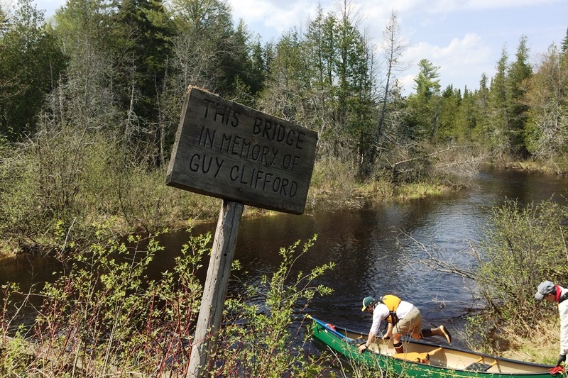
Canoe Launch at the Dixie Road Bridge (2017)
 N45° 46' 19.70\" W68° 8' 52.01\"")
Old Bridge Abutment? near the Stream (2017) @
Form of Government: Assessors-Annual Meeting.
Additional resources
Maine. Department of Inland Fisheries and Wildlife. “Wytopitlock Lake. http://www.state.me.us/ifw/fishing/lakesurvey_maps/aroostook/wytopitlock_lake.pdf (accessed March 13, 2014)
Maine. Land Use Regulation Commission. http://www.maine.gov/dacf/lupc/reference/zoning_maps/Aroostook/glenwood-plt_11x17.pdf (accessed March 13, 2014)
Varney, George J. A Gazetteer of the State of Maine. 1886. p. 253.