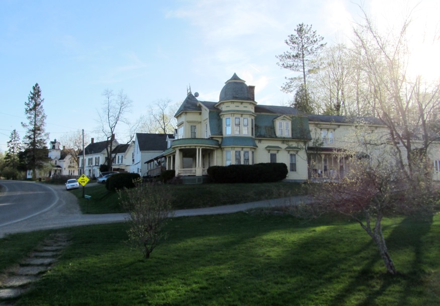
The Geneva House and other grand houses in Danforth Village (2013)

Location Map for Danforth
| Year | Population |
|---|---|
| 1970 | 794 |
| 1980 | 826 |
| 1990 | 710 |
| 2000 | 629 |
| 2010 | 589 |
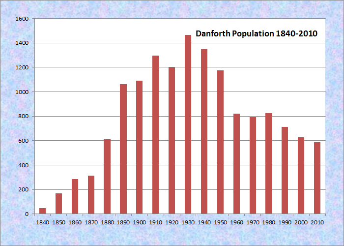
Population Trend 1840-2010
| Geographic Data | |
|---|---|
| N. Latitude | 45:37:25 |
| W. Longitude | 67:50:47 |
| Maine House | District 141 |
| Maine Senate | District 6 |
| Congress | District 2 |
| Area sq. mi. | (total) 60.9 |
| Area sq. mi. | (land) 54.4 |
| Population/sq.mi. | (land) 10.8 |
County: Washington
Total=land+water; Land=land only |
|
 N45° 39' 31.11\" W67° 52' 1.16\"")
Union Hall Community Center (2013) @
 N45° 39' 30.05\" W67° 52' 0.84\"")
Veterans Memorial (2013) @

[DAN-forth] is a town in Washington County, organized as a plantation on August 8, 1847 from the unorganized townships T8 R3 and T8 R4.On March 17, 1860, it was incorporated as a town, following which it annexed land from Weston in 1885 and from the former town of Eaton in 1887.
 N45° 39' 35.35\" W67° 52' 5.84\"")
Houses along Baskahegan Stream at the Village (2013) @
 N45° 39' 34.41\" W67° 52' 6.30\"")
Dam on Baskahegan Stream at Danforth Village (2013) @
Northernmost town in Washington County, it lies in the Baskahegan valley. The village is at the junction of U.S. Route 1 and Maine Route 169 on the north end of a long lake known as the Crooked Brook Flowage. The lake, fed by Baskahegan Stream, has a maximum depth of 20 feet and is prone to deep swells and whitecaps when the wind blows strongly from the north or the south. It is about four miles long and not much more than a half-mile wide in a northwest-southeast crescent shape.
 N45° 36' 36.80\" W67° 48' 2.82\"")
Service Station and House in the Village (2013) @
 N45° 39' 35.55\" W67° 51' 54.47\"")
Entering the Village from the South on U.S. Rt 1 (’13) @
Danforth’s eastern boundary is Grand Lake, separating the United States from Canada. In the west, it borders on Upper and Lower Hot Brook Lakes. Both are attractions for fishing.
The majestic Union Hall, with a clock tower, was completed in 1888. The Town of Danforth owns the lower story; the Masonic and Odd Fellow Lodges, the upper story. It serves as the town’s community center, performance space, and location for the Veterans Memorial. The basement once doubled as a temporary jail.
 N45° 39' 32.26\" W67° 52' 0.77\"")
Downtown Danforth (2013) @
 N45° 39' 35.56\" W67° 52' 3.46\"")
Danforth Post Office (2013) @
After the U.S. entered World War I, Company I of the 103rd Infantry was stationed in Danforth to guard railroad bridges on the Maine Central between Vanceboro and Mattawamkeag. Typical of the surrounding area, Danforth has been losing population in recent years. Interestingly, the population in 1880 was 612, not much different from recent decades.
The town has retained several impressive houses, including the first three below.
At right is the “Geneva House,” described by the Maine Historic Preservation Commission as “a one-and-one-half-story Italianate style residence built circa 1870. The house is of wood-frame construction and retains its original granite foundation.”
 N45° 39' 35.02\" W67° 52' 10.58\"")
The Geneva House in the Village (2013) @
 N45° 39' 37.54\" W67° 51' 55.45\"")
Large House in Danforth Village (2013) @
 N45° 39' 38.38\" W67° 51' 55.04\"")
Large House in the Village (2013) @
")
Town of Danforth Library (’13)
 N45° 39' 38.62\" W67° 51' 50.05\"")
East Grand PreK-12 (’13) @
 N45° 39' 25.62\" W67° 51' 59.05\"")
Danforth Fire Station (2013) @
 N45° 39' 29.80\" W67° 52' 3.52\"")
Building near the Railroad Tracks (2013) @
 N45° 39' 34.59\" W67° 52' 6.57\"")
Railroad Bridge over Baskahegan Stream (2013) @
 N45° 36' 36.80\"")
Church near Eaton Village in Danforth (2013) @
Thomas Danforth, for whom the town is named, was granted one of the two half townships that became the new town.
Form of Government: Town Meeting-Select Board-Manager.
Additional resources
Carleton, George, Mrs. Souvenir Letter: Danforth, Me. Buffalo, N.Y. Douglas Pub. Co. 190-? [University of Maine, Raymond H. Fogler Library, Special Collections]
A Copy of the First Town Records of Danforth, Maine, County of Washington: a copy of the stones in the first cemetery Danforth, Maine. Portland, Me. Daughters of the American Revolution, Elizabeth Wadsworth Chapter. 1945. [Maine State Library]
Love, Wilbur J. A History of Danforth, Maine. 1932?
*Maine. Historic Preservation Commission. Augusta, Me. Text and photos from National Register of Historic Places: http://pdfhost.focus.nps.gov/docs/nrhp/text/82000742.PDF and http://pdfhost.focus.nps.gov/docs/nrhp/photos/82000742.PDF
**PAL. HISTORIC ARCHITECTURAL RECONNAISSANCE SURVEY STETSON II WIND FARM PROJECT T8R4 NBPP, Washington County, Maine. August. 2008. https://www1.maine.gov/dacf/lupc/projects/windpower/stetson/stetson_II/DP4818_Ex14.pdf (accessed March 31, 2015)
Porterfield, Elizabeth, Jenny Fields, and Stephen Olausen. HISTORIC ARCHITECTURAL RECONNAISSANCE SURVEY, STETSON II WIND FARM PROJECT, T8R4 NBPP, Washington County, Maine. Topsham, Me. Stantec. 2008. https://www.maine.gov/dacf/lupc/projects/windpower/stetson/stetson_II/DP4818_Ex14.pdf (accessed March 10, 2014)
Springer, Lorraine, “Union Hall, Danforth, Me. 6X.” Virtual Exhibits. Penobscot Marine Museum. http://penobscotmarinemuseum.org/PMM-Reader/union-hall-danforth-me-6x/ (accessed May 11, 2013)
National Register of Historic Places – Listings
Union Hall
[near junction of US Route 1 and Maine Route 169] Union Hall is the most conspicuous landmark in town. (photo above) This handsome and relatively intact building houses much of the community’s political, social and fraternal events. The upper floor was apparently acquired in 1906 by the Masonic and Odd Fellows lodges.
It was built around 1890 by the Union Hall Corporation as a public space complete with an auditorium. Danforth then had a voting population of 269. Served by the Maine Central Railroad, it had at least eight general merchants and a number of small factories.
The Hall was designed by Edwin E. Lewis of Gardiner, a prolific late 19th and early 20th century Maine architect whose commissions came from a wide geographic area in Maine and portions of New England.*
Historic Buildings not Listed
The Geneva House
[87 Springfield Road, State Route 169] The 1892 Geneva House is a 1½ -story Queen Anne style residence built by a lumber baron with Second Empire style elements. The wood-frame house retains its original granite foundation, clapboard siding, and some original wood roof shingles. Several high-style ornamental elements remain, including towers, a wrapping front porch with paired columns, protruding wood lintels and lintel hoods, and gable dormers. A detached barn adjacent to the house has been altered with vinyl siding, replacement doors, and a 1950s bay window. [See photo above] **
I am interested in Church near Eaton Village. N 45 degrees. 36′ 36.80. Has it been abandoned? Is there a possibility of purchase and historic rehabilitation?
Thank you.
Consider contacting the Danforth Town Office: 18 Central St, Danforth, ME 04424
Phone: (207) 448-2321
They may give you a lead.