 N45° 57' 33.37\" W68° 21' 39.97\"")
Potato Storage Facility near a Railroad Siding on the Cow Team Road in Crystal

Location Map for Crystal
| Year | Population |
|---|---|
| 1970 | 281 |
| 1980 | 303 |
| 1990 | 349 |
| 2000 | 285 |
| 2010 | 269 |
Population Trend 1830-2010
| Geographic Data | |
|---|---|
| N. Latitude | 46:00:02 |
| W. Longitude | 68:21:56 |
| Maine House | District 145 |
| Maine Senate | District 2 |
| Congress | District 2 |
| Area sq. mi. | (total) 40.2 |
| Area sq. mi. | (land) 40.1 |
| Population/sq.mi. | (land) 6.7 |
County: Aroostook
Total=land+water; Land=land only |
|
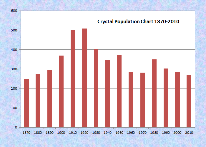
[KRIS-tahl] is a town in Aroostook County whose organization as a plantation was “legalized” by the Legislature on February 21, 1878. It incorporated as a town on March 21, 1901. Its population in 1880 was 275, not far from the average of 297 for the period 1970-2010.
 N46° 1' 9.46\" W68° 20' 43.37\"")
Former Crystal Elementary School (2014) @
 N46° 0' 22.66\" W68° 18' 16.16\"")
Former Church now a Residence (2014) @
William Young from Searsmont was the first settler in 1839. Several others arrive in that year and shortly thereafter.
Crystal Stream, the outlet of Crystal Lake, flows through the town named for the clear water of both. A falls of about 15 feet exists near the center of the town.
The Thousand Acre Bog, once known as Caribou Bog, dominates the southwest portion. Fish Stream winds through it from Patten to Island Falls. The stream crosses Route 159 at N46° 0′ 36.76″ W68° 18′ 45.53″ in the photos below.
")
")
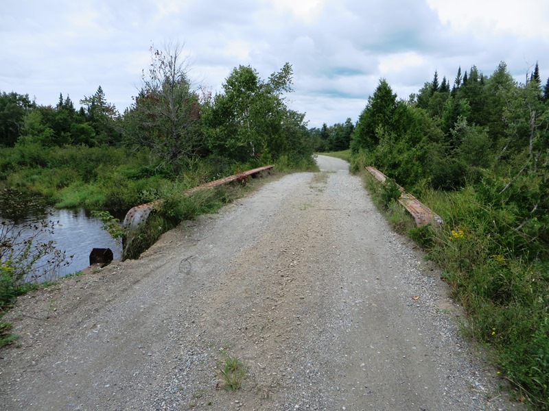
Bridge over Fish Stream on Webber Road (2014)
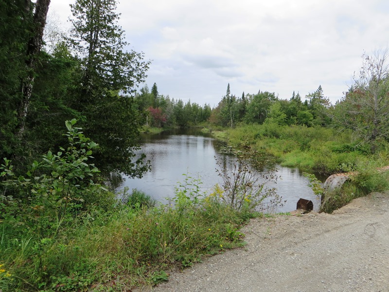
Fish Stream on Webber Road (2014)
On the Webber Road the stream crosses at N45° 58′ 13.34″ W68° 21′ 34.82″.
The Bog is considered one of Maine’s “Focus Areas of Statewide Ecological Significance,” of the Maine Natural Areas Program. According to the Program,
The Crystal Bog Focus Area encompasses an extensive suite of wetlands. At the core of the site is 1400 acre Crystal Bog, one of Maine’s best examples of a Domed Bog Ecosystem. In addition to these large wetland features, the site supports one of Maine’s most diverse fens and a large number of rare plants and animals.
The areas are not regulated but act as a planning tool. Identification of Focus Areas are intended to help build regional awareness and concentrate conservation initiatives in areas with the greatest biodiversity significance. It is accessible from the Sherman to Patten 6-mile multiple use (bike, hike, ski, ATV, snowmobile) Cow Team Trail.
 N45° 58' 0.01\" W68° 22' 3.38\"")
East End of Cow Team Trail in Crystal (2014) @
 N45° 58' 26.47\" W68° 22' 54.13\"")
Log Yard on Cow Team Trail in Crystal (2014) @
 N45° 58' 29.18\" W68° 22' 47.92\"")
Thousand Acre Bog on Cow Team Trail (2014) @
Most of this rural town’s roads are in the northwest of the township near Patten. Route 159 in this area features a few houses, a potato house, an active railroad crossing, a seed supplier, and a large classic barn.
")
Train at Railroad Crossing
")
Seed Pro Inc. Facility
")
Classic Barn
")
")
")
The Crystal railroad siding, once a busy site for potato shipments, is accessed in the southeast, by the Cow Team Road crossing over I-95 from Sherman. The bulk of the town’s population lies between Patten and Island Falls on Maine Route 159 and the Winding Hill Road.
 N45° 57' 33.98\" W68° 21' 40.39\"")
Railroad crossing Cow Team Road (2014) @
 N46° 1' 12.65\" W68° 20' 47.42\"")
Crystal Town Office on Route 159 (2014) @
 N45° 57' 33.93\" W68° 21' 41.01\"")
Railroad Siding in Crystal at the Cow Team Road (2014) @
 N45° 57' 31.59\" W68° 21' 37.15\"")
Potato Storage Facility and related Building on the Cow Team Road in Crystal (2014) @

Crystal Bog: Maine Natural Areas Program
Aside from the wetlands around Cold Brook and the bog, Crystal has substantial woodlands. Harvesting provides logging employment for local equipment operators.
 N45° 57' 19.88\" W68° 21' 26.99\"")
Wood Yard on the Cow Team Road (2014) @
 N45° 57' 19.83\" W68° 21' 26.56\"")
Wood Yard on the Cow Team Road (2014) @
Form of Government: Town Meeting-Select Board-Manager.
Additional resources
Collection of Papers Related to Crystal Plantation. 1875-1897. Maine State Library.
Corliss, Carlton Jonathan. The Story of Crystal [manuscript]: before 1900. 1937. [University of Maine at Presque Isle. Special Collections.]
Maine. Department of Agriculture, Conservation and Forestry. Natural Areas Program. “Focus Areas of Statewide Ecological Significance: Crystal Bog.” http://www.maine.gov/dacf/mnap/focusarea/crystal_bog_focus_area.pdf (accessed March 6, 2014)