 N44° 57' 2.55\" W67° 26' 13.40\"")
Lake Cathance (2013) @

Location Map for Cooper
| Year | Population |
|---|---|
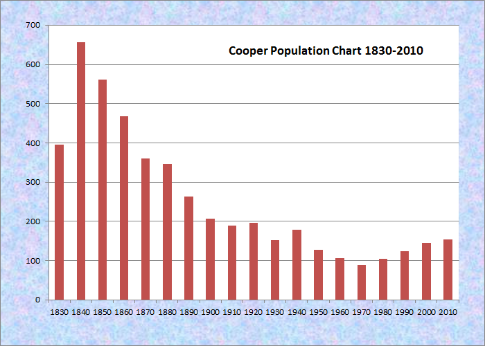
| 1970 | 88 |
| 1980 | 105 |
| 1990 | 124 |
| 2000 | 145 |
| 2010 | 154 |
Population Trend 1830-2010
| Geographic Data | |
|---|---|
| N. Latitude | 45:00:14 |
| W. Longitude | 67:25:59 |
| Maine House | District 141 |
| Maine Senate | District 6 |
| Congress | District 2 |
| Area sq. mi. | (total) 32.9 |
| Area sq. mi. | (land) 31.1 |
| Population/sq.mi. | (land) 5.0 |
County: Washington
Total=land+water; Land=land only |
|
 N44° 59' 52.72\" W67° 27' 45.58\"")
Cooper Community Center (2013) @
[KU-per] a town in Washington County, was incorporated on February 6, 1822 from Plantation Number 15 ED, BPP. It set off land to Alexander in 1838, and to form part of Meddybemps in 1841.
It was named for an early and well-respected settler, General John Cooper. At age 24, he was High Sheriff and jailer for all of Washington County and the principal owner of “wild land” in what is now Cooper. His grave is in the General Cooper Cemetery on private property near the Cathance Grange.
Early settlement, beginning in 1812, took place in three areas including Grove (where the Grange is located), East Ridge and West Ridge.
John Cooper settled here in 1816, when he built a sawmill and grist mill. He built a substantial residence, destroyed by fire in 1976.
Population peaked in 1840, then declined precipitously until climbing again with the ‘back to the land’ movement of the 1970s, and the vacation/retirement settlement along lakefront properties of more recent decades.
In 1825 Cooper had three school districts and one hundred scholars. At the peak of its population, it had six one-room schoolhouses.
The West Ridge School closed in the 1920s, the North Union School, in 1942; the East Ridge School was the last to close in 1957. It is the only schoolhouse still standing, now a private residence.
In the 1800s residents earned their living primarily from lumbering and agriculture. They continue to be the primary sources of income for many.
Four dairy farms were on the North Union Road and others were elsewhere in Cooper, but none remain today. A grist mill was located at Mill Pond.
Early sawmills provided for the local market. In the 1800s there were mills in North Union off Dead Stream and at the end of West Ridge. Another mill off Whiff Hill operated until 1950. A lathe and shingle mill also operated on Old Mill Road. None are currently active.
 N44° 57' 4.61\" W67° 26' 17.47\"")
Road to Lake Cathance from Route 191 (2013) @
Blueberries are one of three fruits native to this area, the others are cranberries and grapes. Only blueberries are a commercial crop. Their fields, currently about 1100 acres, give Cooper its fine open areas and scenic views.
There were two logging camps. One, on the Love Lake Road, was known as the “City’s chopping road.” From the 1920s to 1940s it was used by the city of Calais for logging work by those receiving general assistance. This land is now encumbered by the Sunrise Easement held by the New England Forestry Foundation. The other camp was located across from the former landfill and operated in the 1940s by Sheriff Ray Foster, who brought prisoners to work in the woods.
The oldest house still in use was built in the 1850s on Dodge Road. Several other homes date back to the late 1800s including the homestead on East Ridge of Abiah Day, a Civil War veteran.
Many farmhouses and buildings have long since collapsed or burned. In the early 1900s many farmers headed west, resulting in open lands and hay fields growing back to brush and forest. Woodlands are full of scattered rock piles, stone walls, cellar holes and abandoned wells. The only remaining open land in Cooper of any significance is blueberry land.
Cooper has few public or community buildings. Exceptions are the Cathance Grange, built in 1911, and the Cooper Fire House, built in 1968.
 N44° 57' 2.38\" W67° 26' 13.32\"")
Lake Cathance (2013) @
Until the early 1980s, dwellings on Cathance Lake were primarily seasonal. Since then many of the smaller cottages have been renovated into year round homes. (These images of the lake and cottages were taken in 2013.)
 N44° 57' 2.27\" W67° 26' 13.28\"")
Cabin at Lake Cathance (2013) @
 N44° 57' 2.46\" W67° 26' 14.98\"")
Cabin at Lake Cathance (2013) @
Washington County Railroad came to Ayers Junction at Pembroke in 1898. Shipping by truck and travel by automobile has replaced the need for the rail line.
Before the arrival of the automobile, a trip between Machias and Calais took two days by horse and buggy, and required a stopover. Cooper was the logical place to put up for the night. Catering to the needs of travelers was an early source of income for some residents. The General Cooper house operated as an inn for the travelers.
This small town has managed to grow in population despite its somewhat isolated location. Cooper’s major road is Maine Route 191 that begins in Baring to the northeast, makes a sharp turn to the south in the middle of the town and drops southward to East Machias.
The main village, in the western part of the township, fronts on Lake Cathance, on which the town has substantial frontage. The East Ridge Road runs north-south in the eastern portion of the township, with several minor roads intersecting it.
Form of Government: Town Meeting-Select Board.
Additional resources
Varney, George J. A Gazetteer of the State of Maine. 1886. pp. 179-180.
Washington County Council of Governments. Cooper 2010 Comprehensive Plan. http://www.wccog.net/assets/files/cooper/ (accessed May 17, 2013). The text above is primarily a condensed version of the Plan’s “Section B Historical and Archaeological Resources.” Images are copyright Maine: An Encyclopedia.