
Pennamaquan Lake in Charlotte (2004)

Location Map For Charlotte
| Year | Population |
|---|---|
| 1970 | 199 |
| 1980 | 300 |
| 1990 | 271 |
| 2000 | 324 |
| 2010 | 332 |

Population Trend 1830-2010
| Geographic Data | |
|---|---|
| N. Latitude | 45:0:32 |
| W. Longitude | 67:16:09 |
| Maine House | District 140 |
| Maine Senate | District 6 |
| Congress | District 2 |
| Area sq. mi. | (total) 34.1 |
| Area sq. mi. | (land) 31.3 |
| Population/sq.mi. | (land) 10.6 |
County: Washington
Total=land+water; Land=land only |
|
")
[SHAR-lot] is a town in Washington County, incorporated on January 19, 1825 from Plantation T3 ED, PS.
Bisected by Maine Route 214 connecting Pembroke and Meddybemps, Charlotte, named for the wife of an early settler, is bounded on the east by the Dennys River.
The first settlement was established about 1807-1810 by several men by the names of Bridges, Damon, Truesdale and Fisher. In 1886 it had five public schools and, in 1880, a population of 489.
At Blanchard Corner on Route 214, both Round Lake and Pennamaquan Lake are accessible by the road leading eastward. According to Eckstorm, the Indian word Pennamaquan in its various forms essentially refers to a maple ridge as a source for maple syrup.
Beginning in Charlotte’s Pennamaquan Lake and extending through Pembroke along the Pennamaquan River is the Pennamaquan Wildlife Management Area. This 1,500-plus acre site offers opportunities for boating, canoeing, hunting, fishing, and viewing of eagles, deer and waterfowl.
The Lake itself spans 1,209 acres north of U.S. Route 1, and accessible off Mount Tom Road in Charlotte. According to the 1999 lake survey, the dominant fisheries are for smallmouth bass and pickerel. Some bass attain attractive sizes from 2-3 lb. Pickerel are abundant and are of average size, although some fish reach weights of 3- 3.5 lb. Brown trout was introduced in 1997 to give anglers a salmonid to fish for.
Form of Government: Town Meeting-Select Board.
Additional resources
Charlotte Sesquicentennial Committee. Charlotte, Maine Sesquicentennial, 1825-1975. Charlotte, Me. The Committee. 1975.
Eckstorm, Fannie Hardy. Indian Place Names of the Penobscot Valley and the Maine Coast.
Fisher, Lewis Beals. Story of a Down East Plantation; Facts and Fancies about the Pine Tree State, by one of the Tribe of Fishers. Chicago. 1915?
Maine. Department of Inland Fisheries and Wildlife. “Pennaquam WMA.” http://www.maine.gov/ifw/wildlife/management/wma/region_c/pennamaquam.htm (accessed February 16, 2012)
“Pennamaquan Lake.” Maine. Department of Inland Fisheries and Wildlife. https://www.maine.gov/ifw/docs/lake-survey-maps/washington/pennamaquan_lake.pdf (accessed December 10, 2019)
*Maine. Historic Preservation Commission. Augusta, Me. Text and photos from National Register of Historic Places: http://pdfhost.focus.nps.gov/docs/nrhp/text/05001442.PDF and http://pdfhost.focus.nps.gov/docs/nrhp/photos/5001442.PDF
Starboard, Henry. Account Book. 1860-1862. (Cataloger Note: A volume used by Starboard to record purchases made by customers presumably at a general store in Charlotte, Maine. Goods purchased include cotton, buttons, tea, soap, candles, potatoes, etc. Entries are headed both Charlotte and Pembroke, Maine. The volume also records Starboard’s work for others, much of which involved making barrels, hoop poles, and tubs. Another part of the volume contains records of Enoch Fisher of Charlotte, Maine, and details his activities as justice of the peace, assessor, overseer of the poor, and selectman in Charlotte.)
Varney, George J. A Gazetteer of the State of Maine. 1886. p. 170.
National Register of Historic Places – Listings
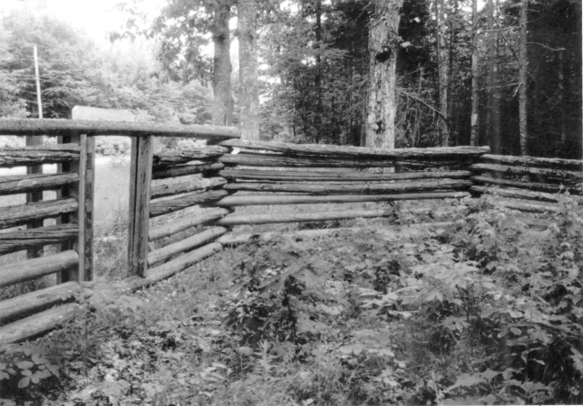
Charlotte Pound
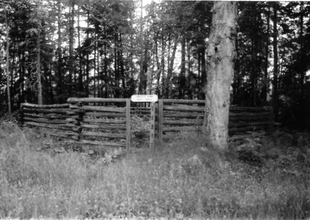
Charlotte Pound (2002)
As Maine communities began to lose some of their frontier aspects in the early 19th century and assumed a more settled appearance, rudimentary civic improvements were initiated. Among these was the regulation of the increase of livestock that inevitably found their way into cultivated fields and gardens. To control this problem towns built shelters for the temporary control of wayward animals. After decades of little use, the Charlotte pound became overgrown and was generally forgotten.
Charlotte Pound (2002)
Interest in the town’s history was increased when it celebrated its sesquicentennial in 1975. The history of the Charlotte Pound was included in the Historical Souvenir Book published at the time. Two years later an article in DownEast, noted that the cedar rails had “split and weathered.” In 1989 with Town support, volunteers documented the structure and replaced those sections of the cedar logs that had failed. The Charlotte Pound is one of 21 in Maine, but the only wooden one to survive. Many towns initially built pounds of wood, but were replaced with stone structures. The Charlotte Pound is an extremely rare and important example of this type of civic structure. [Christi A. Mitchell photos]